
Date of Hike: 4/28/13
Lincoln Woods Trail: 2.9 miles / Bondcliff Trail: 7.9 miles / West Bond Spur: 1.0 miles / Bondcliff Trail: 7.9 miles / Lincoln Woods Trail 2.9 miles
Total Miles: 22.8 (4,800 elevation gain)
Trip Report:
- There are few places in the White Mountains that can match the secluded beauty of the Bonds. It all starts off at one of the most popular trailheads in the White Mountains, Lincoln Woods. On a nice spring weekend the lot fills up quickly with people walking to Franconia Falls, Black Pond, or just out for a stroll along the Lincoln Woods Trail. However, when you arrive at 6:45 a.m. in late April it's a different world; it's quiet, there's a chill in the air, and you can hear the water flowing from East Branch of the Pemigewasset Wilderness.
- I'll let the pictures do the reporting for this one...Enjoy!
 Lincoln Woods
 East Branch Pemigewasset Suspension Bridge
 East Branch
 Hurricane Irene 'Washout' Outlook on the Lincoln Woods Trail
 Lincoln Woods Trail
 Sun shining through the woods in the early morning
 Franconia Brook Footbridge
 Pemigewasset Wilderness Boundary
 Bondcliff / Franconia Brook Trail Junction
 Bondcliff Trail
 Bondcliff Trail
 Old Railroad Ties
 Flooded section along the Bondcliff Trail
 Camp 16 Junction
 Bondcliff Trail
 Black Brook Crossing #1
 Black Brook Crossing #2
 Monorail starting to form
 Gravel slide section
 Final Water Crossing of the Black Brook
 Bondcliff Trail
 The short steep scramble below Bondcliff's summit
 Mount Lafayette and Lincoln as seen from above the scramble
 Loon Mountain Ski Area
 Osceola's
 Scar Ridge
 West Bond
 Hancock's
 Bondcliff and West Bond
 Summit of Bondcliff
 Owl's Head and the Franconia Ridge
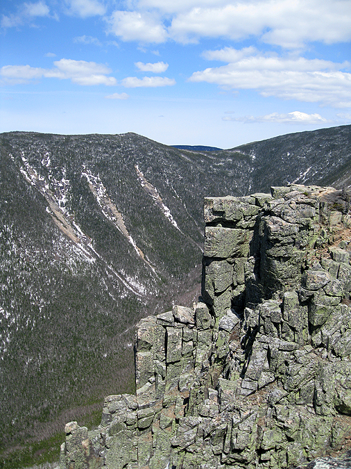
 Mount Bond from Bondcliff
 Owl's Head Southern end with Mount Liberty and Flume Moutain
 Bondcliff from Mount Bond
 Mount Tom, Field, Willey, and the Presidential Range as seen from Mount Bond
 West Bond, Mount Lincoln, Lafayette, and Garfield
 West Bond, Mount Lincoln, and Lafayette
 Guyot and the Twin Range
 West Bond Spur Path
 The final exposed section leading up to West Bond
 Twin Range
 Slides of the Twin Range
 Pemigewasset Wilderness
 West Bond Summit Area
 Bondcliff from West Bond
 Bonacliff Ridge, the Hancock's and Carrigain
 Mount Bond
 Osceola's
 Bondcliff
 West Bond Spur / Bondcliff Trail Junction
 Alpine Zone
 Boncliff Trail
 Heading back to Mount Bond
 Mount Tom, Field, Willey, and the Presidential Range
 Bondcliff Trail
 Bondcliff Trail
 Admiring Bondcliff
 Bondcliff Trail and Mount Bond
 Enjoying the Cliffs of Bond
 Pemi Wilderness
 Bondcliff
 Hancock's and Carrigain
 Hancock's and Carrigain
 Pemi Wilderness
 View towards Scar Ridge and the Osceola's from Bondcliff
 Bonfcliff, Mount Bond, and West Bond
 Bondcliff Summit Area
 Bondcliff
 Bondcliff Trail
 Bondcliff Trail
 Black Brook Railroad Trestle
 Black Brook RR Trestle
 Bondcliff Trail
 Bondcliff Trail
 Bondcliff Trail
 Bondcliff Trail
 Rotting, moss covered Railroad Ties
 Back to reality, Franconia Brook Bridge
 East Branch Pemigewasset Suspension Bridge

East Branch and the Kanc
Awesome pictures - couldn't have been a better day. Question - do you run your hikes - LOL? You make better time than anyone I know, including me and I never stop to rest! You're blog is a great reference - I feel like I have already been down the trail when I hit something new!
ReplyDeleteHi, Glad you enjoy the pics, thanks!
DeleteI don't usually run unless I'm with other hikers who do. I do hike fast below treeline and don't usually stop unless there is an outlook, trail junction, or a water crossing. I stop above treeline a lot for pictures and to take in the views but have been lucky that I'm a good rock hopper so the rough footing doesn't slow me down.
Happy Hiking!
Great recap of this hike! I know it's not a sanctioned campsite any more, but do you know if it is possible to still set up camp at Camp 16 for the night? We are planning to camp in the valley before heading up Bondcliff and ultimately doing the whole Pemi loop.
ReplyDeleteThanks!
Hi Jason, glad you like the trip report, thanks! I have seen tents at the back end of camp 16 before. As long as you're 200 feet back you are all set. If it was me I'd set up in towards the back of the clearing and if a ranger came by and told me to move if not 200' back then I would. I don't think you can have a fire though, not 100% sure but it's posted on the wilderness signs.
DeleteHave a great Pemi Loop! It's on of my favs!
If you every have any questions just email me at cdailey@hpearce.com and I'll try and answer them as best as I can
Hey man, great photos, they got me super fired up for my hike with my buddies. They are helping me visualize the hike. We're planning the same hike to Bondcliff-Bond-West Bond in June 2014. We are setting up a base camp somewhere off the Wilderness Trail before the turn for Bondcliff and hoping to bag all three peaks in one day. Anyway, just wanted to say thank you for posting so many good photos with good descriptors.
ReplyDeleteHi James, Glad you liked the pictures. Have a great hike with your friends!
Delete