Showing posts with label Jewell Trail. Show all posts

Sarge's First Presidential Undercast . . . From Mount Washington

Date of Hike: 4/25/19

Jewell Trail: 3.7 Miles  /  Gulfside Trail: 2.8 miles  / Jewell Trail: 3.7 miles
Total Miles: 10.2 (4,318 feet elevation gained) Garmin Forerunner 920XT

Trip Report:
- Long time, no trip report!  I have still been hiking with Sarge quite frequently, with an Instagram page for him here (sgt._pepper_goldendoodle).  Also, all my hikes automatically get uploaded to Strava, so unless it's one of my original routes or one where I snapped some really good pictures, I will not be updating the blog as much.  Luckily, there are a tremendous amount of reports here over the past ten years making for a solid catalog of data and info for hikers to peruse through.  My Strava profile is here (Chris Dailey Strava), you need Strava to view my hikes and follow me, but I do upload the links to the trip report page on this blog and those can be viewed individually.

- On Thursday, Sarge and I joined Ashley for a spring hike of Mount Washington.  Trail conditions have drastically changed over the past two weeks in the White Mountains, from deep solid snowpack to mud, running water, and snow with failing monorail.  I chose the Jewell Trail because it melts out relatively fast compared to the Amoonoosuc Ravine Trail which holds snow much longer below treeline as it doesn't get good sun exposure.
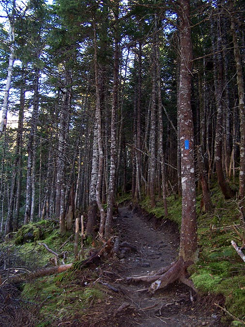
- The first two miles were mostly bare ground with a few tenths of a mile of rotting snow.  The last mile to treeline was when conditions got really interesting, balance beam of snow, some solid, some failing.  It was quite the workout, we made the best of it and laughed off our slip and falls.
- When we broke above treeline conditions were still tedious as the previous days snowfall was melting fast but made things very slippery.  We were hiking in thick clouds when all of a sudden around 5,800 feet we were suddenly above the clouds in bright sunshine!
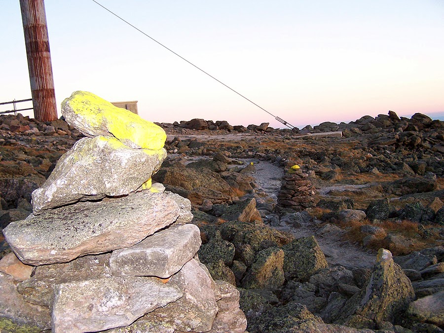
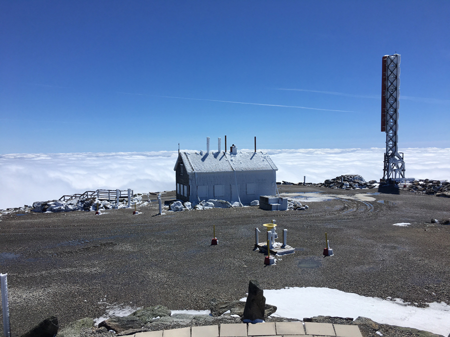
- We moseyed our way up to the observation deck enjoying the undercast.  At the summit, Ashley went inside to visit her OBS friends who work up there, (fyi, the observatory is still closed to the public).  Sarge and I basked in the sunshine and hung out on the deck until Ashley reappeared with some cookies the staff made!
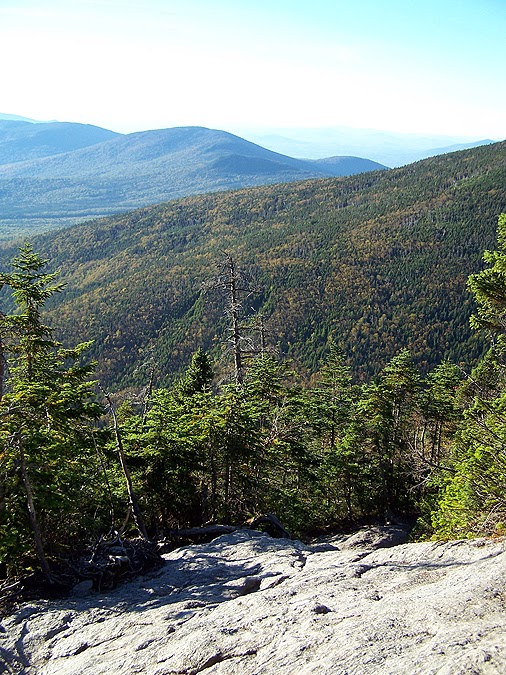
- After chilling on the summit and snapping photos we started to descend, and just as we started heading down the clouds broke open below us making for stunning views of the Great Gulf and the Northern Presidential Range.
- We timed our descent perfectly, the views kept get better and the trail had now melted and dried up making our drop back to treeline much easier.  Once back in the woods we battled the failing monorail for a mile before a relaxing last two miles back to the car.
- It was a great day to head up to the rock pile, Sarge had a blast and so did Ashley and I. :)

 Below treeline, hiking on top of the rare Old Man's Beard monorail

Sarge at the tracks wanting to see a train

Still waiting for that train!

Top of Mount Washington

Sarge with a sea of clouds behind him

Summit photo!

Ashley on top of the tower

Just hanging out

Ashley and Sarge on Washington!

Sarge enjoying the undercast

I'm going to dodge it.  Train dodge, dig it!

Trust me, this is his excited face!

 Clearing out of the Great Gulf

This was pretty cool to see as we hiked back down

Ashley enjoying the clearing of the Great Gulf

Peekaboo Sarge, do you see him??!!

First Timers up the Rock Pile . . . Mount Washington

Date of Hike: 7/27/15

Jewell Trail: 3.0 miles  /  Gulfside Trail: 1.5 miles  /  Crawford Path:  1.5 miles  /  Ammonoosuc Ravine Trail: 3.4 miles
Total Miles: 9.4 miles (3,950 feet elevation gained)

Trip Report:
- On Monday, Whitney and I hiked Mount Washington with her friend Alice, her boyfriend, Ken, and their two year old Pittbull - Rottwieler mix, Lucy.  It would be the first time hiking Mount Washington for all three so we decided to head up the Jewell as it has the easiest grades and footing, and lacks the crowds that the Tuckerman Ravine and Lion Head trails have.
- To save some time we started our hike from Marshfield Station instead of the Ammonoosuc Ravine Trailhead.  We also lucked out that we arrived to the lot before they started charging hikers for parking, score!
- The ravines were all blanketed in a thick layer of fog but as we hiked they quickly blew off and we had great in and out of the clouds views for our whole hike.
- Alice, Ken, and Lucy impressed me a lot for their first time hiking Mount Washington.  Usually people take it for granted and get worn down, but they knew what it took to hike the mountain and did great.  Lucy impressed me the most as she set the pace the whole day and rocked the rock pile!
- As we broke above treeline we got to watch the first cog train head up the tracks from across Burt's Ravine.  The first train that is sent up everyday is the old coal train, after that the trains that go up and down are clean burning diesel trains.  I have a soft spot for the not-so-environmentally-friendly old dirty train.  The whistle has a distinct sound, it train itself has a unique old sound as it crawls up the tracks, and it blows a column of smoke high up into the sky...it reminds me of my childhood riding on the train and then hiking by it every time after that when I hiked up Mount Washington via the Jewell and the Gulfside trails.
- When we reached the summit we were happy to see that it was not too crowded and there was no wind.  The summit cone was in the clear while everything surrounding the cone was in a cloud, we were in the 'eye' of a school of clouds, something I never had experienced on the summit before.
- We decided to hike down the Crawford Path to the Lakes of the Clouds Hut and then steeply descend the Ammonoosuc Ravine trail.  On the hike down to the hut we went in and out of the clouds.  At first Lucy didn't know what to do when the clouds came rushing in and blanketed the trail, she seemed a little unsure but after a few moments she just joyfully continued down the trail.
- We took a short break in the hut where I went in and decided to check out the old log books, specifically August of 1988.  Amazingly I found the book up on the shelf mixed in with about one hundred others and started to flip through the pages.  When I came to the August 30th entries I stumbled upon what I was looking for, my dad's entry into the log book followed by one from my brother.  At the time I was nine years old, my brother was just shy of twelve years old.  We had hiked up the Ammonoosuc Trail that morning and stayed at the hut, followed by hiking up to the summit and down the Jewell the next morning.  It was my first time hiking Mount Washington, almost twenty-seven years ago and forty-seven previous summit ascents before!
- After our break at the hut we headed down the Ammo and made sure to stop at the Gorge and the Gem Pool on our way out.  I hiked with Lucy a lot of the way down.  It's always fun to have a dog around, they always have me smiling :)

Heading to the Jewell Trail at Marshfield Station.  The original start to the trail used to be here before it was relocated down the road a half mile.

There used to be a foot bridge at the water crossing next to the tracks but it got washed out this past spring (bottom).  Ken heads through the narrow treed trunk forest of the Jewell Trail (top).

 The Jewell Trail has very good footing and moderate grades below treeline.

 Breaking out above treeline and looking to the west as the clouds break apart.

 Clouds clearing off of Mount Monroe to the south.

 The Cog makes its first appearance.

 Choo choo!

  Approaching Jacob's ladder.

 The Great Gulf Wilderness from high above on the Gulfside Trail.

 Making our way past the tracks and up to the summit.

 Mount Washington's summit and weather observatory.

 After relaxing on the summit we head down America's oldest maintained trail, the Crawford Path.

 Lucy heads to our next destination, Lakes of the Clouds Hut.

 Lakes of the Clouds!

 The hut.

 Inside the hut I found the log book from 1988.  My dad always had this thing about being the Griswold's (from National Lampoon's Family Vacation) on our trips up north.  This one reads, "We are enjoying our 'White Mountain" "Vacation" Clark W. Griswold + Family.  P.S. Better than the European one but not quite like Wally World.  Aunt + dog not with us.  We are really the Dailey's." The aunt and dog is another reference to the movie.  If you remember, they had to pick up Aunt Edna and she died in the back seat so they strapped her to the roof.  They also had the dog with them, which Clark tied to the back bumper and forgot about and drove away.

 My brother signed the book. He loved and still loves Kermit the Frog, as you can see from the frog drawing.  "Finally Here, Joe Dailey (the artist)"

 Heading down the slab of the Ammonoosuc Ravine Trail.

 The falls of the upper ammo, the Gorge, and the Gem Pool.

Route for the day, click here for details

Sunset in the Presi's: Monroe and Washington Loop

Date of Hike: 9/20/13

Ammonoosuc Ravine Trail: 3.1 miles  / Monroe Loop Trail: 0.6 miles / Crawford Path: 1.7 miles  /  Gulfside Trail: 1.4 miles  /  Jewell Trail: 3.1 miles  /  Base Road: 0.5 miles
Total Miles: 10.4 miles (4,200 feet elevation gain)

Trip Report:
- Friday I hit the trail at 5pm and zoomed up the Ammonnosuc Ravine Trail with the idea to catch sunset somewhere along the Crawford Path between Lakes of the Clouds and the summit of Mount Washington.
- The weather was absolutely perfect for the second to last night of the summer.  Temps were in the high 50's and the wind was light and variable for the whole hike.  the Ammo Trail is one of my favorites in the Whites, it starts off gradual for the first two miles to the Gem Pool.  From here you gain over 1,500 feet in just one mile.  It's relentlessly steep with ok to rough footing, which is right in my wheel house!
- As the Ammo Trail gains elevation it travels near and across some small cascades over ledges as the trees grow smaller and the views of Washington get bigger.
- As I started to gain the ridge I smelled food, hut food!  I thought I was going coo-coo bananas because I always remembered Madison Springs and Lakes of the Clouds huts to be closed by early September.  To my surprise I reached the hut just before six as the guests where milling around outside enjoying the weather and views before eating a yummy dinner.
- I quickly headed up and down Mount Monroe to get the classic Lakes of the Clouds and Washington summit cone view from the Monroe Loop Trail and the Southern Presidential Range view from the summit of Monroe.
-  As I passed by the hut they were now serving food, it smelled really good and I thought about heading in to try and score a free meal but I was making great time and now could make it close to the summit before sunset.
-  I was still in a t-shirt as I made my way up to the summit cone as the day faded away.  The shadows kept growing, the sun kept dropping, and the colors kept changing from yellow to gold to orange to purple, red, blue, and orange all at once.
- The sun slowly set behind the Green Mountains of Vermont and I could pick out Mount Mansfield's profile of the 'chin', 'nose', and 'forehead' off in the distance.
- I made it to the summit just as the sun vanished while standing on the observatory deck at 6,288 feet as darkness slowly fell around me.  There was one OBS volunteer up there taking pictures, he would be the last person I saw until I got back to my car.
- It was a little cooler on the summit, temps in the 40's and light wind so I put on my long sleeve and my light mittens before heading down the cog tracks to intercept the Gulfside Trail at the Westside Trail junction.
- From here I rocked hopped my way to the Jewel Trail junction were I had my supper, a PB&J sandwich.  I finally had to put on my headlamp on the Jewell Trail.  Eventhough the sun set about a half hour ago it was still easy enough to navigate above treeline with no light.  I did hike too fast so the full moon wasn't even close to dominating the sky above, if it was I wouldn't have needed my headlamp until treeline.
- The hike out in the dark was peaceful and calming.  I was back in a t-shirt and mitten-less a few minutes after heading down the Jewell Trail.  I could see distant lights from houses and cars down in the valley as I made my way back to my car.  It was a quick hike and run back to the car, my headlamp lights up the trail so I was comfortable running with no issues.
- When I reached the junction that lead to the old Jewell trailhead which began at the Cog Station I took it and enjoyed the nice half mile walk along Base Road back to my car, ending a perfect sunset hike!
 
 Nice little rock hop section on the lower end of the Ammonoosuc Ravine trail
 A new short re-route near a washout
 Ammonoosuc River
 Gem Pool
 Above the Gem Pool the Ammo Trail gets steep
 A short little ladder to help the vertically challenged ;)
 Looking down a slab section of the trail
Small cascades along the trail
 'Algae' Cascade
Upper ends of the Ammonoosuc River 
 Stairway to the Alpine Zone
 A helpful sign to keep you headed the right way
 Gaining the ridge, Lakes of the Clouds Hut
 The last train of the day passes by Jacob's Ladder
 Lakes of the Clouds and Mount Washington
 Lakes of the Clouds Hut
 Lil' Monroe and the Southern Presidential Range
 Lil' Monroe
 View from the summit of Mount Monroe
 Mount Clay and Jefferson, if you look really closely you can see Mount Adams, looks like a shadow to the right of Clay!
 Mount Washington Hotel and Golf Course
 Summit cone of Mount Washington
 Late day sun shining bright over the western shoulder of Mount Monroe
 Lakes of the Clouds Hut
 The hut and the Ammonoosuc Ravine Trail junction
 Crawford Path heading north
 Mount Monroe and Lakes of the Clouds Hut
 The Crawford Path has had exception trail work since it's heavily used
 Golden grass fields of Mount Washington
 Mount Monroe
 Lakes of the Clouds
 One of the best views in the Whites, a little more than 24 hours later there were 50 mph winds, low visibility, and driving rain! 
 Twin Range, Franconia Ridge, and the 'Moose' to the south
 Sun slowly falling to the west
 A grassy knoll about a half mile from the summit
 Southern Presidential Range
 The final 0.3 miles to the summit
 Sunset at 6:43 p.m.
 Twin Range and Franconia Ridge in a purple Haze
Southern Presidential Range during twilight 
 Newly painted rocks near the top!
 Sunset over the Green mountains
 Summit Cone
 All alone on Mount Washington's summit
 Mount Jefferson, Adams, and Madison
 Observation deck at sunset
 Mount Madison and Madison Springs Hut
 Mount Jefferson
 A plane flying southwest as the sun dissapears
 Sunset from the observatory
 Cog Tracks
 Mount Washington OBS - 'Castle in the Clouds'
 Mount Masfield
 Getting darker
 The Gulfside Trail
 Beautiful mix of colors while skirting around Mount Clay's summit cone on the Gulfside Trail
 Gulfside / Jewell Trail junction
 Jewell Trail
 Ammonoosuc Brook
 Cog Station at Base Road
Historical marker at the Cog Station on Base Road