
Date of Hike: 9/28/14
Hancock Notch Trail: 1.8 miles / Cedar Brook Trail: 0.7 miles / Hancock Loop Trail: 1.2. miles / Bushwhack: 4.5 miles / Cedar Brook Trail: 2.1 miles / Hancock Notch Trail: 1.8 miles
Total Miles: 12.11 (3,350 feet elevation gained)
Trip Report:
- Sunday's hike was all about off trail adventure! I joined Whitney and Tim for a steep hike up the Arrow Slide to North Hancock, followed by a bushwhack over to Northwest Hancock, #71 of #72 for Tim's Trailwights 72. The descent off of Northwest Hancock would be down the steep, loose, and crazy looking Cedar Slide.
- I had been on the Arrow Slide before in 2010 and was happy to be doing it again, especially since I'd be able to take pictures of hikers on it for some perspective on the steepness of the talus and slab filled slide.
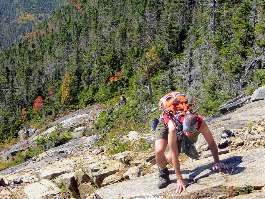
- The bottom of the slide can be reached from the flat campsite area just before the North Link of the Hancock Loop junction ascends steeply. The bottom of the slide is narrow and filled with different sized loose boulders. It then opens up at a slimy slab section and becomes a mix of slab and loose talus. Just like in 2010 I tried to head up a steep slab section on the left in the middle of the Arrow Slide and had to climb down, then cross to the right, then cross back to the left to the giant cairn at the Arrow Split.
- The climb up the slide is steep, and there is loose rock in places. Whitney dislodged a decent sized piece of talus, (size of a skateboard) that went tumbling down towards Tim. Tim maneuvered out of the way by jumping to his left and over the falling piece of rock. It was a definite heart stopper for a moment. Close call!
- Views from the slide are pretty cool. You get a great view of South Hancock above and to the left, and a nice view across the way over to the Osceola's.
- We took the right exit from the top of the slide. Last time I took the left exit and luckily managed to pop out exactly at the summit. I remember it being thick and had heard that the right exit was thick but short. Unfortunately, the three of us weren't smart enough to put on long sleeves or pants and we paid for it by getting scrapped up a little. It was hellishly thick, thickest whack I could remember, but within ten minutes we were out on the path and another minute after that we reached the summit, covered in pine needles and a little blood!
- From just past the summit we jumped back off trail and headed literally into the middle of nowhere. Tim lead us by compass most of the way, checking the GPS track here and there, every time he checked we were pretty close to the track. Thank goodness for Tim, for the first time I had no clue where we were for awhile, my bearings were all over the place until catching a glimpse of Carrigain through the trees to my right at about 4 o'clock, with Northwest Hancock at 12 o'clock.
- The bushwhack was thick in spots but mostly it was ok. There was no herd path, except for a minor one the last tenth of a mile or so. It was never hellishly thick, just some gnarly but small blowdown patches.
- The summit of Northwest Hancock is just over 4,000 feet and the area is very small and narrow. It's in the middle of the woods with no views but there is a cool little canister, an old summit sign, telephone wire, a piece of metal, and an old mini iron door to some railroad train. Northwest Hancock is also on the NH 93 fire tower list.
- After taking a break we descended back to around 3,900 feet and angled down and to the right at about 1 o'clock, intercepted an old haul / skidder road and eventually left that and popped out on the top of the Cedar Slide around 3,800 feet. Tim once again lead the way and kept us on track and made sure we entered the slide at the top so we wouldn't miss any of the fun that is the Cedar Brook Slide.
- The Cedar Brook Slide, reminded me of a Lincoln Slide, except it's smaller and trickier. The slide is definitely more 'alive' as footing is an issue with the loose gravel and boulders move a lot at the steep top section.
- The slide had been ripped to shreds from Hurricane Irene and Tropical Storm Sandy Pants. There are huge washouts within the slides, creating a half pipe feel in certain spots. You can tell where the old sections of the slides still remain as they were covered with red brick type talus with some ground vegetation, while the ripped up parts were covered in golden gravel and big boulders.
- Views from the slide were phenomenal, and the foliage just added to the experience as we made our way down to the bottom of the slide to the start of the brook.
- We jumped to the left out of the brook and Tim lead us through a thick Christmas tree forest before finally popping out on the Cedar Brook Trail about a mile and a half from the junction with the Hancock Loop Trail. The hike out went by quickly, which was good because I'm pretty sure my stomach was eating itself, I was craving a ton of food!
- We made it back to the car just after 5 p.m. brushed the pine needles off of us and changed into dry clothes. Whitney and I headed into town to stuff our faces at the Common Man, before she met up with our friend Denise, and I headed back to RI.
- It was a perfect ending to one of the best two days of foliage hiking I've had in awhile. Thanks to Tim for being our navigational leader, and many thanks to Whitney for two awesome back to back hikes!


Hancock Notch Trail: 1.8 miles / Cedar Brook Trail: 0.7 miles / Hancock Loop Trail: 1.2. miles / Bushwhack: 4.5 miles / Cedar Brook Trail: 2.1 miles / Hancock Notch Trail: 1.8 miles
Total Miles: 12.11 (3,350 feet elevation gained)
Trip Report:
- Sunday's hike was all about off trail adventure! I joined Whitney and Tim for a steep hike up the Arrow Slide to North Hancock, followed by a bushwhack over to Northwest Hancock, #71 of #72 for Tim's Trailwights 72. The descent off of Northwest Hancock would be down the steep, loose, and crazy looking Cedar Slide.
- I had been on the Arrow Slide before in 2010 and was happy to be doing it again, especially since I'd be able to take pictures of hikers on it for some perspective on the steepness of the talus and slab filled slide.
- The bottom of the slide can be reached from the flat campsite area just before the North Link of the Hancock Loop junction ascends steeply. The bottom of the slide is narrow and filled with different sized loose boulders. It then opens up at a slimy slab section and becomes a mix of slab and loose talus. Just like in 2010 I tried to head up a steep slab section on the left in the middle of the Arrow Slide and had to climb down, then cross to the right, then cross back to the left to the giant cairn at the Arrow Split.
- The climb up the slide is steep, and there is loose rock in places. Whitney dislodged a decent sized piece of talus, (size of a skateboard) that went tumbling down towards Tim. Tim maneuvered out of the way by jumping to his left and over the falling piece of rock. It was a definite heart stopper for a moment. Close call!
- Views from the slide are pretty cool. You get a great view of South Hancock above and to the left, and a nice view across the way over to the Osceola's.
- We took the right exit from the top of the slide. Last time I took the left exit and luckily managed to pop out exactly at the summit. I remember it being thick and had heard that the right exit was thick but short. Unfortunately, the three of us weren't smart enough to put on long sleeves or pants and we paid for it by getting scrapped up a little. It was hellishly thick, thickest whack I could remember, but within ten minutes we were out on the path and another minute after that we reached the summit, covered in pine needles and a little blood!
- From just past the summit we jumped back off trail and headed literally into the middle of nowhere. Tim lead us by compass most of the way, checking the GPS track here and there, every time he checked we were pretty close to the track. Thank goodness for Tim, for the first time I had no clue where we were for awhile, my bearings were all over the place until catching a glimpse of Carrigain through the trees to my right at about 4 o'clock, with Northwest Hancock at 12 o'clock.
- The bushwhack was thick in spots but mostly it was ok. There was no herd path, except for a minor one the last tenth of a mile or so. It was never hellishly thick, just some gnarly but small blowdown patches.
- The summit of Northwest Hancock is just over 4,000 feet and the area is very small and narrow. It's in the middle of the woods with no views but there is a cool little canister, an old summit sign, telephone wire, a piece of metal, and an old mini iron door to some railroad train. Northwest Hancock is also on the NH 93 fire tower list.
- After taking a break we descended back to around 3,900 feet and angled down and to the right at about 1 o'clock, intercepted an old haul / skidder road and eventually left that and popped out on the top of the Cedar Slide around 3,800 feet. Tim once again lead the way and kept us on track and made sure we entered the slide at the top so we wouldn't miss any of the fun that is the Cedar Brook Slide.
- The Cedar Brook Slide, reminded me of a Lincoln Slide, except it's smaller and trickier. The slide is definitely more 'alive' as footing is an issue with the loose gravel and boulders move a lot at the steep top section.
- The slide had been ripped to shreds from Hurricane Irene and Tropical Storm Sandy Pants. There are huge washouts within the slides, creating a half pipe feel in certain spots. You can tell where the old sections of the slides still remain as they were covered with red brick type talus with some ground vegetation, while the ripped up parts were covered in golden gravel and big boulders.
- Views from the slide were phenomenal, and the foliage just added to the experience as we made our way down to the bottom of the slide to the start of the brook.
- We jumped to the left out of the brook and Tim lead us through a thick Christmas tree forest before finally popping out on the Cedar Brook Trail about a mile and a half from the junction with the Hancock Loop Trail. The hike out went by quickly, which was good because I'm pretty sure my stomach was eating itself, I was craving a ton of food!
- We made it back to the car just after 5 p.m. brushed the pine needles off of us and changed into dry clothes. Whitney and I headed into town to stuff our faces at the Common Man, before she met up with our friend Denise, and I headed back to RI.
- It was a perfect ending to one of the best two days of foliage hiking I've had in awhile. Thanks to Tim for being our navigational leader, and many thanks to Whitney for two awesome back to back hikes!
Hancock Notch and Cedar Brook Trail
The Arrow Slide and starting up from the bottom of the slide
Loose jumbled boulders fill the narrow bottom section of the slide
Whitney and Tim making there way through the lower end of the slide
Reaching the slime-slab section
The slab of the Arrow Slide
The Arrow Slide is steep, it gains elevation quickly
Whitney crossing from left to right below the slime-slab
Looking down the Arrow Slide
Whitney and Tim scrambling
Whitney looks like she is 'Perplexed and Pondering!'
Whitney on the Slide!
Taking in the views to the Osceola's
Whitney, safely scrambling up
The top of the Arrow Slide!
Tim scrambles up
The top of the Slide and Tim covered in pine needles!
Bushwhack over to Northwest Hancock
Old 'artifacts' / bushwhacking / a haul-skidder road
Dropping into the Cedar Slide
Top of Cedar Slide
Whitney and Tim navigating the slide
The Cedar Slide is steep and loose up top!
Whitney approaches the middle of the slide
The Cedar Slide!
The Cedar Slide
Funneling down the slide
Whitney walks around car sized boulder
Tim on the left side of the Cedar Slide
Tim, taking in the great views
Heading down to a ripped up section from previous storms
Whitney and Tim enter the half pipe
Tip-Toeing down the slide
Lower end of the slide
Looking back up the Cedar Slide
One last Bushwhack!
Dry Land!
Track for the day (Click here for more details)
Arrow Slide (the track is off a little)
Northwest bushwhack and Cedar Slide


