
Date of Hike: 7/21/18
Lincoln Woods Trail: 1.4 miles / Osseo Trail: 4.4 miles / Franocnia Ridge Trail: 5.0 miles / Garfield Ridge Trail: 6.6 miles / Frost Trail: 0.8 miles / Twinway 0.8 miles / North Twin Spur: 2.6 miles / Twinway: 2.0 miles / Bondcliff Trail: 0.8 miles / West Bond Spur: 1.0 miles / Bondcliff Trail: 3.0 miles / Twinway: 4.3 miles / Lend-A-Hand Trail: 5.4 miles / Twinway: 0.4 miles / Zealand Trail: 0.3 miles / A-Z Trail: 2.7 miles / Mount Tom Spur: 1.2 miles / Willey Range Trail: 3.5 miles / Ethan Pond Trail: 1.5 miles
Total Miles: 48.85 (17,210 feet elevation gained) AMC White Mountain Guide Online
Trip Report:
- Friday night at 9:30PM I moseyed my way up to Mount Flume from Lincoln Woods. I wanted to reach the summit just before midnight before taking off at midnight for a 100K route through the heart of the White Mountains.
- The hike up Flume went well and I was not alone as I would pass by a half dozen other hikers along the way, these would be the last people I would see until dawn!
- I reached Flume's summit around 11:50 and took a break while looking up at the stars shining brightly high above me. After ten minutes of relaxing and organizing my gear I started my adventure.
- It was rough going during the night heading over Franconia Ridge, I wasn't moving as fast as I had planned and then the Garfield Ridge, my old nemesis, destroyed me during the wee hours of the night, needless to say it became apparent really quickly that I might have to revamp my route and mileage.
- Even with the slower than expected pace I was still having an enjoyable nighttime hike, especially above treeline where the stars and Milky Way looked spectacular. During one of my breaks on North Lafayette, I saw a shooting star fly across the sky to the northwest. I also spied a few planes high in the sky, flying east/northeast, maybe they where flying to Europe??!!
- Some of the other highlights as I made my way across Garfield Ridge were the sounds of dozens of frogs as I made my way past Garfield Pond, stargazing for a few minutes from the summit of Mount Garfield, and carefully making my way down the waterfall section of the trail just below the Garfield Campsite, which luckily was easy since it's been an incredibly dry summer, still it was quite the adrenaline rush dropping down that section of trail.
- The rest of the night hiking went ok, after a few hours I started looking forward to not having to go by headlamp as the final few miles leading up to Galehead Hut and the summit weren't too exciting. After a short stop at Galehead Hut I was able to ditch my headlamp at 5AM as I started my way up South Twin.
- I reached the summit of South Twin just as the sun was rising up behind the Presidential Range, another really cool sight to see. South Twin usually has a pretty constant stream of hikers on it's open summit so it was nice to have the top to myself and enjoy the peace and quiet.
- From South Twin I made and out and back of North Twin before heading over to the Bonds. From here on out I would be seeing more and more hikers, starting along the Twinway near Guyot and every five to ten minutes as I made my way to West Bond, Bond, and Bondcliff before turning around and heading back to the Twinway.
- It was still early in the morning when I dropped below treeline towards Mount Zealand around 9AM. I had until 5PM to reach Ethan Pond trailhead off 302, earlier I texted Whitney for a car pickup, deviating from my intended route, so I had the whole day to make it there.
- I made good time to Zealand and then down to the hut, where I bought a piece of chocolate cake and relaxed before heading up to Mount Hale via Lend-A-Hand Trail. This would be one of my last big climbs of the day, luckily the Lend-A-Hand Trail has mostly easy to moderate grades with good footing, there are two short steep rugged bursts over the last mile but that's it for the tough stuff.
- It was an easy out and back from the hut to Hale. Once again, I took a break and had some food and refueled while preparing my gear for the climb out of Zealand Valley to the Willey Range along the A-Z Trail. This would be my last big climb of the day, and just like hiking up to Hale most of it was along easy to moderate grades with great footing before getting steeper and more rugged for the last three quarters of a mile. The A-Z Trail between Zealand Trail and Willey Range Trail is lightly used so I had this 2.7 miles all to myself. However, once I gained the ridge it was a totally different story, hikers everywhere!
- I was a bit perplexed as to why so many hikers were out on this viewless range on a perfect above treeline day. I must have see 50 hikers between Tom-Field-Willey, no wonder why the trail is severely eroded in a few spots, none worse than just below Mount Willey, it's a disaster! I carefully picked my way down this eroded mess, I was over forty miles in so it was a minor miracle I didn't slip and fall back on my butt at least once, victory!
- Once past the steep eroded part, the trail finally moderates and the footing quickly gets much better as the Willey Range Trail terminates at the junction with the Ethan Pond Trail (A.T.). From here I slow jogged down to the trailhead where trail magic was going on for thru-hikers. The smell of food on the grille was too overbearing and made me very hungry, so instead of waiting for Whitney there I headed to down the road to the 302 junction. Since I finished at 3:15PM, I had a long wait before my ride would come, I spent the time stretching for a good twenty minutes, telling SoBo hikers there's trail magic right up the road, and almost dozing off while I sat on the side of the road.
- Whitney and Sarge came by around 4:45PM and we then retrieved my Jeep at Lincoln Woods before heading back to Gorham where I stuffed my face with food!
- It was a great 17 hour and 45 minute adventure in the heart of the White Mountains, and with some minor tweeking (start at dawn from Flume), I'll come back in the future and complete my intended 100K route 24 hour route. :)
Map of my route for the night/morning/day
Elevation over distance profile
View from Frost Trail Outlook, the hut, and heading up the Twinway
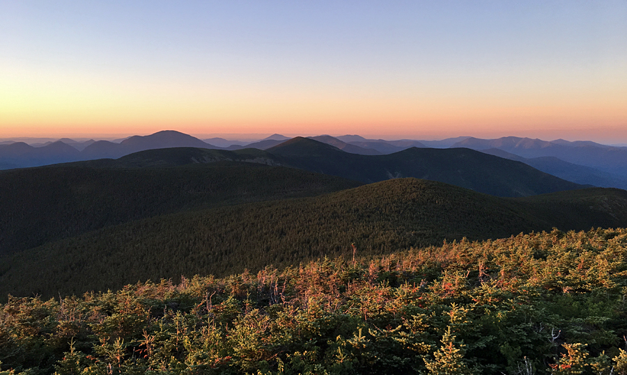
Sunrise from South Twin :)
South Twin Summit at daybreak
Looking towards Guyout and the Bonds
Pemi Wilderness as seen from North Twin. Shadows quickly retreating as the sun rises
Mount Bond and West Bond as seen from Mount Guyot
Redrock Ravine as seen from West Bond
Bondcliff
West Bond, Owl's Head, and the Franconia Ridge as seen from Mount Bond
Bondcliff Ridge
Bondcliff and Hellgate Ravine
Slides of Hellgate Ravine, close up of the new slide!
Mount Guyot
Hiking along the Twinway
Lend-A-Hand Trail, summer vs. winter!
Hiking near Zealand Pond
Mount Tom Spur
Hiking along the Willey Range Trail
Webster Cliff as seen from Mount Willey
The eroded Willey Range Trail
Fantastic phitos and report as always! I caught a sunrise from S. Twin after leaving Guyot early one morning, your photo and write up brought back great memories! Daverip26
ReplyDeleteThanks Dave, I'm glad you enjoyed the trip report and pics. Hope you have or will get to enjoy another sunrise soon from the Whites. :)
Delete