
Date of Hike: 2/15/16
Mount Carter Drive & abandoned Stony Brook Trail: 1.2 miles / Stony Brook Trail: 2.3 miles / Carter - Moriah Trail: 2.7 miles / Stony Brook Trail: 2.3 miles / Abondoned Stony Brook Trail & Mount Carter Drive: 1.2 miles
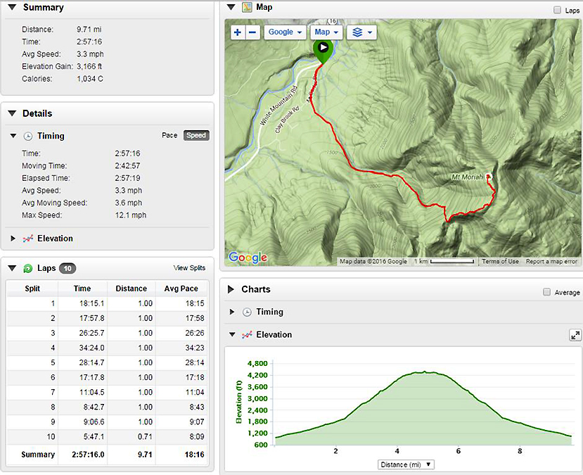
Total Miles: 9.7 miles (3,166 feet elevation gained) Garmin Forerunner 910XT
Trip Report:
- With only two peaks left to finish off my February grid, Moriah and Moosilauke, I have the luxury of cherry picking perfect weather days to enjoy the hikes. This weekend saw an arctic blast sweep across all of the northeast, luckily it was short lived and temperatures which were in the negatives double digits in higher elevations warmed up quickly to a balmy twenty degrees with almost no wind by noon on Monday. Twenty degrees with abundant sunshine and no wind made for a pretty easy hike up from the cul-de-sac in the Stony Brook neighborhood.
- Conditions were close to perfect along the old logging road that gradually makes its way up to the Carter-Moriah trail junction. Of the 3.5 miles it takes to gain the ridge, the grade only steepens in a few short bursts over the last half mile, other than that it's a breeze.
- From the junction I headed north along the Carter-Moriah Trail for close to a mile and a half to the summit of Mount Moriah. The trail passes over a few open ledges with beautiful views of the northern Presidential Range, the Carter Range, the Wild River Wilderness, and a far off view of the Kilkenny Range to the west. In my opinion this route up to the summit is far superior to the approach from Bangor Road over Mount Surprise. It's a half mile longer on both ends but definitely a more scenic hike.
- Once I made it to the top I decided to trail run down the mountain as conditions allowed me to maintain a good controlled speed. On the way out I passed another guy who lives in the neighborhood, he was out for an afternoon walk up to the highest water crossing where the old logging road deteriorates. It was nice to see someone else out enjoying another mild winter day!


Mount Carter Drive & abandoned Stony Brook Trail: 1.2 miles / Stony Brook Trail: 2.3 miles / Carter - Moriah Trail: 2.7 miles / Stony Brook Trail: 2.3 miles / Abondoned Stony Brook Trail & Mount Carter Drive: 1.2 miles
Total Miles: 9.7 miles (3,166 feet elevation gained) Garmin Forerunner 910XT
Trip Report:
- With only two peaks left to finish off my February grid, Moriah and Moosilauke, I have the luxury of cherry picking perfect weather days to enjoy the hikes. This weekend saw an arctic blast sweep across all of the northeast, luckily it was short lived and temperatures which were in the negatives double digits in higher elevations warmed up quickly to a balmy twenty degrees with almost no wind by noon on Monday. Twenty degrees with abundant sunshine and no wind made for a pretty easy hike up from the cul-de-sac in the Stony Brook neighborhood.
- Conditions were close to perfect along the old logging road that gradually makes its way up to the Carter-Moriah trail junction. Of the 3.5 miles it takes to gain the ridge, the grade only steepens in a few short bursts over the last half mile, other than that it's a breeze.
- From the junction I headed north along the Carter-Moriah Trail for close to a mile and a half to the summit of Mount Moriah. The trail passes over a few open ledges with beautiful views of the northern Presidential Range, the Carter Range, the Wild River Wilderness, and a far off view of the Kilkenny Range to the west. In my opinion this route up to the summit is far superior to the approach from Bangor Road over Mount Surprise. It's a half mile longer on both ends but definitely a more scenic hike.
- Once I made it to the top I decided to trail run down the mountain as conditions allowed me to maintain a good controlled speed. On the way out I passed another guy who lives in the neighborhood, he was out for an afternoon walk up to the highest water crossing where the old logging road deteriorates. It was nice to see someone else out enjoying another mild winter day!
Heading up the cul-de-sac and then hooking onto the lower end of the Stony Brook Trail
Gaining the Carter-Moriah Ridge and making my way north past the first open ledge
What a view! The Carter-Moriah Trail breaks into the open a handful of times as it snakes its way up to the summit
Carter Range on the left with the northern Presidential Range behind it and to the right
Mount Washington, Clay, Jefferson, Adams, and Madison (L to R)
View from the summit of Mount Moriah. Presidential Range (top), North Moriah, Shelburne Moriah, and the Mahoosuc Range (bottom)
Heading back down the chute just below the summit
What a nice day to be out!
Kilkenny Range to the west. Waumbek, Weeks, Terrace, Cabot, Bulge, The Horn, etc.
Back out to the cul-de-sac and Mount Carter Drive
Signs spotted along the way
Route for the day, click here for details
Great pics ! I will consider that route when we hike Moriah. Thanks for the post. Wendy
ReplyDeleteThanks, Wendy. It's a nice little trail to take up to the ridge line :)
ReplyDelete