
Date of Hikes: 12/5/15 & 12/6/15
Livermore Trail: 2.7 miles / Mount Tripyramid Trail: 3.3 miles / Pine Bend Brook Trail: 0.8 miles / Scaur Ridge Trail: 1.1 miles / Livermore Trail: 3.8 miles
Total Miles: 11.7 miles (2,984 feet elevation gained)
Lincoln Woods Trail: 2.8 miles / Franconia Falls Trail: 0.5 miles / Fisherman's Path: 1.5 miles / Lincoln Brook Trail: 2.5 miles / Owl's Head Path: 1.75 miles / Brutus Bushwhack: 0.7 miles / Lincoln Brook Trail: 2.8 miles / Camp 9 RR Grade Bushwhack: 0.4 miles / Franconia Brook Trail: 1.3 miles / Lincoln Woods Trail: 2.9 miles
Total Miles: 17.2 (3,022 feet elevation gained)
Trip Report:
- Going into December I only had three peaks left to complete the month towards the Grid (hiking all 48-4,000 footers in each month over any given period of time). Luckily with the mild temperatures continuing I was able to hike a couple of slides on my way up the Tripyramids on Saturday and Owl's Head on Sunday. There is some snow and ice so I played it safe and descended via easier routes, Scaur Ridge Trail down from the Tri's and the Brutus Bushwhack down from Owlie. On both hikes I checked out some old railroad camps, Avalanche Camp on the Livermore Trail which is a very distinguishable open field on the side of the trail. The following day while hiking out from Owl's Head I stayed on an old railroad grade a few tenths of a mile before the Lincoln Brook Trail reached the junction with the Franconia Brook Trail and stumbled upon a huge open field/marsh just west of Camp 9 Brook and found a few relics from the old Camp 9.
- Conditions on both hikes were extremely tame for December, the South Slide below South Tripyamid had a few inches of snow and some ice but I was able to make it up with no traction on. The rest of the hike was mostly a breeze along the ridge over Middle and North Tripyramid. There were lots of people out along the ridge with a majority of them coming up from Pine Bend Brook. I ran into Schorman (Grid Finisher #29) on North Tripyramid, just a few tenths of a mile from where I saw him a few weeks back. It was great to stop and chat with him again!
- I headed down the Scaur Ridge Trail which is a very nice and easy alternative to descending the North Slide. There is even an obstructed view this time of year while the leaves are down of the North Slide from the trail which is nice.
- The last four miles was an easy hike over the old Livermore Road back to the car under sunny skies and temperatures hovering around fifty degrees!
On Sunday I originally was thinking of heading over Lafayette and down the Lincoln Slide on my way to Owl's Head with my friend Kyle, however, with the warm temps during the day and the cold night temps, followed by more warmer temps, I didn't want to deal with descending on snow and ice in the slide then bushwhacking over a mile through wet snow and mud.
- I did mix up the hike by using trails and bushwhacks. I started out along the Lincoln Woods Trail for almost three miles, then hiked up to Franconia Falls. Just past the falls the trail abruptly comes to an end, there's even a sign nailed to a tree saying 'END OF TRAIL'
- Past the sign is a well defined herd path, known as the Fisherman's Path. It hugs the Franconia Brook for most of it's length and the whack is about a mile and a half. Two thirds of the time there is a well defined path, the other third is a mix of a sort of defined path to indistinguishable.
- The Fisherman's Path I enjoyed a lot, more so than the Black Pond Bushwhack because it traveled close to the brook and just seemed more scenic to me. The Fisherman's Path comes out just past the second wide crossing on the Lincoln Brook Trail.
- I then made my way gradually up the Lincoln Brook Trail to the base of Owl's Head, put on my micro spikes, and headed up the steep Owl's Head Slide. There was a mix of snow and ice, the spikes came in very handy as I navigated up the icy sections on the upper part of the slide and in the woods just above the slide. Once past the steep icy spots I ran into another hiker, Kim, who was finishing her 47th 4,000 footer, she was overjoyed to have made it to the summit and I took a picture for her. I congratulated her and wished her luck on her upcoming finish on Mount Moosilauke.
- On the descent I opted for the Brutus Bushwhack, there was enough snow on the ground that I followed older boot prints for a little bit, but they just seemed to be heading to far south so I cut off and steeply descended and ended up hitting the old haul road at about the spot I usually find it, just before a gully. I then easily descended the old road and then a tiny drainage back to the Lincoln Brook Trail.
- I stuck to to the trail for most of the way out, past the Fisherman's Path and over the two wide brook crossings. They were very trivial, the first one I made it across with some long leaps and kept my feet dry. The second wide crossing I made it to about ten feet from the river bank and had two ankle deep steps on rocks to deal with. I got wet feet but it was very warm out, plus I had my 'scuba' socks and gaiters on so I wasn't worried.
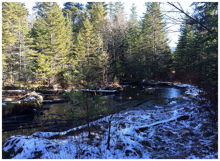
- Just past the last crossing the trail leaves the RR grade to the left, I stayed on the old grade through a wet section and stumbled upon a huge open field/marsh that ended at Camp 9 Brook. I then headed into the woods and found some old 'RR junk' before hooking back onto the Franconia Brook Trail and out to the Wilderness Boundary.
- The hike out along the Lincoln Woods Trail was business as usual, I did go off trail one last time before the Osseo Trail, up above Camp 8 on the old grade referred to as 'Narrow Gauge Line.' The woods are really wide open and the line runs parallel to the Lincoln Woods Trail up above it. The line goes up a side hill too but I just stayed on the flat section, next time I'll head back to see where it goes.
- The last thing I did was head into the Camp 8 clearing and stumbled upon a few old items too, not much is left there however.
- Back at the car I changed into dry clothes and headed over to NoCo to see Whitney while she worked and to watch the Pats game before heading home to Gorham, ending a really fun December weekend hiking :)
- December Grid: Whiteface December 5th, 2009 - Owl's Head December 6th 2015


Livermore Trail: 2.7 miles / Mount Tripyramid Trail: 3.3 miles / Pine Bend Brook Trail: 0.8 miles / Scaur Ridge Trail: 1.1 miles / Livermore Trail: 3.8 miles
Total Miles: 11.7 miles (2,984 feet elevation gained)
Lincoln Woods Trail: 2.8 miles / Franconia Falls Trail: 0.5 miles / Fisherman's Path: 1.5 miles / Lincoln Brook Trail: 2.5 miles / Owl's Head Path: 1.75 miles / Brutus Bushwhack: 0.7 miles / Lincoln Brook Trail: 2.8 miles / Camp 9 RR Grade Bushwhack: 0.4 miles / Franconia Brook Trail: 1.3 miles / Lincoln Woods Trail: 2.9 miles
Total Miles: 17.2 (3,022 feet elevation gained)
Trip Report:
- Going into December I only had three peaks left to complete the month towards the Grid (hiking all 48-4,000 footers in each month over any given period of time). Luckily with the mild temperatures continuing I was able to hike a couple of slides on my way up the Tripyramids on Saturday and Owl's Head on Sunday. There is some snow and ice so I played it safe and descended via easier routes, Scaur Ridge Trail down from the Tri's and the Brutus Bushwhack down from Owlie. On both hikes I checked out some old railroad camps, Avalanche Camp on the Livermore Trail which is a very distinguishable open field on the side of the trail. The following day while hiking out from Owl's Head I stayed on an old railroad grade a few tenths of a mile before the Lincoln Brook Trail reached the junction with the Franconia Brook Trail and stumbled upon a huge open field/marsh just west of Camp 9 Brook and found a few relics from the old Camp 9.
- Conditions on both hikes were extremely tame for December, the South Slide below South Tripyamid had a few inches of snow and some ice but I was able to make it up with no traction on. The rest of the hike was mostly a breeze along the ridge over Middle and North Tripyramid. There were lots of people out along the ridge with a majority of them coming up from Pine Bend Brook. I ran into Schorman (Grid Finisher #29) on North Tripyramid, just a few tenths of a mile from where I saw him a few weeks back. It was great to stop and chat with him again!
- I headed down the Scaur Ridge Trail which is a very nice and easy alternative to descending the North Slide. There is even an obstructed view this time of year while the leaves are down of the North Slide from the trail which is nice.
- The last four miles was an easy hike over the old Livermore Road back to the car under sunny skies and temperatures hovering around fifty degrees!
On Sunday I originally was thinking of heading over Lafayette and down the Lincoln Slide on my way to Owl's Head with my friend Kyle, however, with the warm temps during the day and the cold night temps, followed by more warmer temps, I didn't want to deal with descending on snow and ice in the slide then bushwhacking over a mile through wet snow and mud.
- I did mix up the hike by using trails and bushwhacks. I started out along the Lincoln Woods Trail for almost three miles, then hiked up to Franconia Falls. Just past the falls the trail abruptly comes to an end, there's even a sign nailed to a tree saying 'END OF TRAIL'
- Past the sign is a well defined herd path, known as the Fisherman's Path. It hugs the Franconia Brook for most of it's length and the whack is about a mile and a half. Two thirds of the time there is a well defined path, the other third is a mix of a sort of defined path to indistinguishable.
- The Fisherman's Path I enjoyed a lot, more so than the Black Pond Bushwhack because it traveled close to the brook and just seemed more scenic to me. The Fisherman's Path comes out just past the second wide crossing on the Lincoln Brook Trail.
- I then made my way gradually up the Lincoln Brook Trail to the base of Owl's Head, put on my micro spikes, and headed up the steep Owl's Head Slide. There was a mix of snow and ice, the spikes came in very handy as I navigated up the icy sections on the upper part of the slide and in the woods just above the slide. Once past the steep icy spots I ran into another hiker, Kim, who was finishing her 47th 4,000 footer, she was overjoyed to have made it to the summit and I took a picture for her. I congratulated her and wished her luck on her upcoming finish on Mount Moosilauke.
- On the descent I opted for the Brutus Bushwhack, there was enough snow on the ground that I followed older boot prints for a little bit, but they just seemed to be heading to far south so I cut off and steeply descended and ended up hitting the old haul road at about the spot I usually find it, just before a gully. I then easily descended the old road and then a tiny drainage back to the Lincoln Brook Trail.
- I stuck to to the trail for most of the way out, past the Fisherman's Path and over the two wide brook crossings. They were very trivial, the first one I made it across with some long leaps and kept my feet dry. The second wide crossing I made it to about ten feet from the river bank and had two ankle deep steps on rocks to deal with. I got wet feet but it was very warm out, plus I had my 'scuba' socks and gaiters on so I wasn't worried.
- Just past the last crossing the trail leaves the RR grade to the left, I stayed on the old grade through a wet section and stumbled upon a huge open field/marsh that ended at Camp 9 Brook. I then headed into the woods and found some old 'RR junk' before hooking back onto the Franconia Brook Trail and out to the Wilderness Boundary.
- The hike out along the Lincoln Woods Trail was business as usual, I did go off trail one last time before the Osseo Trail, up above Camp 8 on the old grade referred to as 'Narrow Gauge Line.' The woods are really wide open and the line runs parallel to the Lincoln Woods Trail up above it. The line goes up a side hill too but I just stayed on the flat section, next time I'll head back to see where it goes.
- The last thing I did was head into the Camp 8 clearing and stumbled upon a few old items too, not much is left there however.
- Back at the car I changed into dry clothes and headed over to NoCo to see Whitney while she worked and to watch the Pats game before heading home to Gorham, ending a really fun December weekend hiking :)
- December Grid: Whiteface December 5th, 2009 - Owl's Head December 6th 2015
Depot Camp clearing near the start of the Livermore Trail
Hiking along the Livermore Trail, it's mostly flat and very gradual, you'll see hikers, runners, bikers, x-country skiers (when there's more snow)
After hiking about three miles I take a left onto the Mount Tripyramid Trail and slowly head up to South Peak
The mid-morning sun shining brightly through the woods
Lower part of the South Slide
Upper part of the slide, the views for the North Slide are better but these views are good to. Sandwich Mountain Range off in the distance
Heading up to the ridge, and the view from Middle Tripyramid Outlook over to Waterville Valley and Mount Tecumseh
The Presidential Range (left), Wildcat-Cater Range Right from North Tripyramid's outlook
Heading down the Scaur Ridge Trail
The North Slide as seen from the Scaur Ridge Trail
Avalanche Camp
Heading out back to the car
Signs spotted along the way
---------------------------------------------------------------------------------------------------------------------
Starting early across the Lincoln Woods suspension bridge and Camp 8 clearing
An old trestle foundation and the Franconia Brook footbridge
Franconia Falls
Swimming hole above the falls

End of Trail! Start of the Fisherman's Path
The Path parallels the brook for most of it's length then comes out near a tiny tentsite on the side of the Lincoln Brook Trail
Lincoln Brook and trail
The always muddy Lincoln Brook Trail!
Lower part of Owl's Head Slide
Middle section of the slide
Lincoln Slide and Franconia Ridge
Upper part of the slide was where the ice was!
Looking down the slide
Above the slide there was more ice, followed by bare rock, then snow
Along the ridge on the way to the summit. If you know where to look you can get a nice view across to Lincoln Slide
Owl's Head summit and then descending off the mountain down the Brutus Bushwhack
Along the Lincoln Brook Trail
Lincoln Brook looking oh so cold!
An old piece of railroad equipment near one of the two wide crossings on the Lincoln Brook Trail
Trail goes left, I stayed straight!
Followed the old RR grade, it got a little washed away in spots

Then it breaks out into the open
Nice view of Owl's Head from and open field / marsh
Really glad I stumbled upon this spot!

Camp 9 relics
More from Camp 9
There wasn't much to be viewed, but a few months ago I didn't think anything was left here so I was happy to see this stuff
One of the crossings on the Franconia Brook Trail
Lincoln Woods Trail
On the 'narrow gauge line'
Looking down from the gauge line, if you look closely you can see the Lincoln Woods Trail and a footbridge
Camp 8 clearing and some old RR stuff
Route for Owl's Head. click here for more details
Very nice way to finish your December grid. Thanks for the info on the camps, not too many people take the time to try and find those off trail places and they're really are a treasure to find and explore from a place and time from long ago.
ReplyDeleteTim