
Date of Hikes: 10/2 - 10/5
Mount Tecumseh - Mount Tecumseh Trail and Ski Trails: 4.9 miles (2,220 feet elevation gained)
Wildcat 'D' Peak - Polecat Ski Trails: 5.5 miles (2,060')
Mount Willey & Field - Kedron Flume, Willey Range, & Avalon trails, Crawford Notch Scenic Railroad: 9.5 miles (3,680')
Mount Moriah, South & Middle Carter - Stony Brook, Carter-Moriah, Carter Dome, Nineteen-Mile Brook trails, NH 16: 20.2 miles (5,225')
Mount Jackson - Webster-Jackson Trail: 4.75 miles (2,290')
Trip Report:
- Friday before work I headed over to Waterville Valley for a quick jaunt up Mount Tecumseh. I was on the trail by 7am and it was quite chilly as I made my way to the outlook on the ski trails. I decided to hike up to the ski trail to Sosman Peak before heading over to the summit of Mount Tecumsh.
- It had been a couple of years since I hiked up the ski trails at Waterville Valley, I do enjoy the open views of the slopes and it mixes up the scenery taking the ski slopes one way and the trail the other way. As I gained elevation it was quite clear that the warmer temperatures are gone and will not be coming back until late next May, the wind was starting to cut through me and I knew it was time to put on another layer instead of delayering. The great thing about the cooler and crisp temperatures is the views become much much better, from the ski slopes I had a really nice view of the Osceola's over to the Tripyramids.
- Once I reached the top of the ski slopes I took the Sosman Trail over to the Mount Tecumseh Trail and made the quick ascent up to the summit of Mount Tecumseh. The summit of Tecumseh has taken on a much different look over the past few years as someone has illegally cut trees to open up the view from the summit ledge. There's now even a posted sign warning about illegal cutting, apparently it hasn't worked as the view seems to get bigger each time I'm up there.
- From the summit I descended the trail back to the outlook and then hiked the slopes from here the rest of the way down, making a figure eight for my route during the hike. Unlike the mid to upper slopes, the lower ones were wet in muddy over large areas and the grass wasn't as cut that well. I managed to keep my sneakers mostly dry as I dropped down to the main building and back to the Jeep in time to head into town and start working.
- Friday evening I met Ryan at Wildcat ski area for a sunset run up and down the slopes to Wildcat 'D' Peak. Ryan is one of the best ultra-runners in the northeast, and this past summer he and his wife Kristina were pacers and slackpacked for Scott Jurek on his record breaking A.T. supported speed hike. The portion they helped him through was the Mahoosuc Range, a thirty mile stretch of up and downs over some of the most rugged terrain along the entire Appalachian Trail! So needless to say this was going to be a quick speed hike up the mountain and an all out run back down. The route up the mountain up the ski trails is pretty straight forward as there is an access road that heads up the mountain over the Polecat ski trails, basically the road hugs the left-most (northern) slopes of the mountain. The grade is steep in spots, mostly where the ski trail makes hairpin turns but the footing is pretty great for a ski slope.
- Ryan and I motored up the mountain at a pretty solid clip, we started the ascent at 5:45 so we didn't have much time until we had to put on our headlamps. However, we made such good time up the mountain, forty-two minutes, that we might be able to bomb down the mountain without using the headlamps. Sure enough we descended at a blazing fast pace, making it back to the parking lot in seventeen minutes. on the way down I reached a milestone, for the first time in my life I ran a sub six minute mile at 5:33, granted it was downhill while losing 850 feet but I'll take it!
- Saturday morning Whitney and I had plans to hike but we both decided to get some much needed rest and slept in. In the afternoon Whitney headed to work and I headed up the notch for a nice afternoon hike of Mount Willey and Field. For the first time in a long time my hiking feet were not under me and my pace was very slow as I made my way up the Willey Range Trail. I forgot how eroded and how bad the footing was in spots heading up the mountain from this direction. It really is a relentless climb up to the summit of Willey and not the most enjoyable as there are no views, luckily it's short mileage wise so even at a slower pace it does go by relatively quickly.
- From Willey I made the easy down and up over to Field. Near the summit I heard people off in the woods, I first thought they were bushwhacking but they were just off in the woods talking. I then smelled smoke, apparently they were having a small fire which I don't think is allowed, I hope they didn't burn the ridge down!
- There is a really nice downlook from Field's summit area, a great view of the Southern Presidential Range. I took a short break here and snapped a few pics before making the steep descent down to Mount Avalon where I enjoyed even better views of the range and Crawford Notch.
- Next I headed back to the bottom of the mountain and hooked onto the railroad tracks. Since it was after 5pm and there were no trains running I decided to hiked the tracks three miles back to the Kedron Flume Trail where my Jeep was.
- The walk along the tracks is a lot of fun, you get really unique views and you pass by the old site of the Willard Section House, very little remains except for a partial foundation and a few other items. The house was located next to the Frankenstein Trestle which is pretty freaky to walk over as it crosses a huge gap below high rising cliffs.
- It was a nice hike back via the train tracks but it was getting really cold out so my fingers got chilled up quite a bit reminding me for the second straight day that the colder temps are coming and will be here to stay for quite awhile!
- Sunday I felt refreshed and was up for a long mile day. Whitney and I were going to hike the Hall's Ledge and Hutmen's trail and then she was going to help me with a car spot for my Moriah through South Carter hike while she went to work. Unfortunately, Whitney had a headache so there would be no early morning hike at the bottom of Pinkham Notch. Since I wanted to do twenty miles and Whitney didn't feel well I had no issues with her staying in and not helping me with the car spot, the road walk would just add the miles I wanted to get in.
- I went up Mount Moriah via the Stony Brook Brook and Carter-Moriah trails. This approach I prefer much more than the Carter-Moriah approach from Bangor Road. It's a much easier hike and has views from the upper ledges that are just as good if not better than the one from Mount Surprise from the other side.
- Foliage was a mixed bag, some spots in the valley you could clearly see the colors changing, other spots not so much. The best views for colors were down toward Pine Mountain to the west and areas in the Wild River Valley to the east.
- There weren't many hikers out and about as I made my way up to Mount Moriah. On the summit there was one who was finishing his 48 - 4,000 footers, he picked a perfect fall day to finish. Moriah was my second to last peak, while it was the final peak for my dad when he completed his 48 in the 1990's.
- From Moriah I made the trek across the Carter-Moriah Range over to North Carter. I stopped in at the Imp Shelter to check out the old lean-to. It's situated in a really cool spot with a nice tiny outlook where there's a cute old bench set up.
- From the shelter I made the ascent up to North Carter, I had forgot just how steep the final half mile is up to the summit was, it definitely was the most tiring part of the day. From North Carter across Middle and over to South the hiking is pretty tame compared to most trails between summits, the grade is moderate and the footing is relatively decent. There are limited views between North, Middle, and South Carter, one or two small ledges have decent views, while the best view along this stretch is from a small alpine meadow just below the summit of Middle Carter.
- Once past South Carter I made my way down to Zeta Pass and then back out along the Carter Dome and Nineteen-Mile Brook Trail. The best colors for foliage of the day were along the lower section of the Carter Dome Trail and the Nineteen-Mile Brook Trail near its junction with the Carter Dome Trail.
- The rest of the hike back to the trailhead was rather uneventful. They are in the process of building a new bridge along the trail and they have put in two new reroutes, neither of which I am a fan of and didn't really seem necessary, but I guess it was put in place to avoid a small rock ledge along the brook that may cause hut hikers issues.
- Once back at the trailhead I started the five mile road walk up NH 16 back to the Jeep. I don't mind road walks, I'm careful to watch out for the leaf peepers who have a hard time staying between the lines as they stare up at the trees. Luckily it was late afternoon on a Sunday so most had headed back south. The road walk went by relatively quickly, the first four miles was nice, the last mile kind of dragged, I realized four miles of road walking is my limit on enjoying it, after that I just want to be finished. I made it back to the Jeep in one piece as the temperature quickly started to fall as the shade took over the notch.
- Monday morning I got up early and hiked Mount Jackson before work. It's a pretty straight forward hike around five miles. there are no views until the summit ledges but they are some of the best around. On this day the views were endless and I wished I had started earlier so I could enjoy them more but I had to get back down so I could jump on my computer and start working. I spent somewhere between five and ten minutes up there looking at the cool clouds high above the mountains in all directions. Not a bad way to start the week :)
Hiking the lower section of the Mount Tecumseh Trail
The Tripyramids from the 'Boneyard' Outlook
Hiking up the ski trails under the chair lift with the Osceola's in view
Beautiful fall morning in Waterville Valley
I keep heading up the slopes and duck into the woods at the highest chairlift
The nice pine needle blanketed Sosman Trail
A great outlook from the Sosman Trail. Franconia Ridge on the left, Kinsman Ridge on the right
Heading up to the summit of Mount Tecumseh
Tripyramids from the summit
The summit used to be almost treed in but has been illegally cleared over the past few years
The well place and crafted rock steps of the Mount Tecumseh Trail. Outstanding trail work!
Hiking down the lower ski slopes, a little muddier down here
Kinderpark, always makes me chuckle :)
Signs spotted along the way
Route for the day
The Waterville Valley Ski Trail system
Running up Wildcat 'D' Peak with Ryan
Mileage, elevation, splits
Route for the run
Wildcat Mountain Ski Trail system
--------------------------------------------------------------------------------------------------------------
Willey & Field
Lower end of the Flume Trail
Hiking by the Kedron Flume and the train tracks
Heading up the super steep Willey Range trail
Looking down on Crawford Notch from Mount Willey's summit outlook
Willey and Field summit carins and a blowdown patch between peaks
The Presidential Range looming large over the top of Crawford Notch's Highland Center
Presidential Range
Webster's Cliffs
Crawford Notch Scenic Railroad
Heading along the tracks
Silver Cascade
Willard Section House memorial
Old foundation and flower garden
Next up along the tracks is the famous Frankenstein Trestle!
It's high off the ground and a little freaky to walk over!
Another memorial, this one was just north of the Kedron Flume Trail
Signs spotted along the way
Route for the day
---------------------------------------------------------------------------------------------------------------
Moriah - N. M. S. Carter
The Stony Brook Trail has great footing and easy grades over the first two miles
It gets a little more rugged as it gains the ridge but never becomes too steep, except for a couple of short bursts
Great views from the ledges along the Carter-Moriah Trail
The northern Presidential Range in view
Wild River Wilderness
Pine Mountain and the Kilkenny Ridge lining the horizon
Mount Jefferson, Adams, and Madison
After reaching Mount Moriah's summit I backtracked down to the Stony Brook Trail junction, I stayed straight
Heading towards the Imp and the Carters
Imp shelter
Nice little bench with a view from the shelter
The carter-Moriah Trail
Looking back towards Moriah from the steep section of trail just below North Carter
North Carter, Middle Carter, South Carter
Hiking along the Carter-Moriah Trail
Zeta Pass and a small cascade on the Carter Dome Trail
Heading down the Carter Dome Trail
Foliage starting to break on through along the Nineteen-Mile Brook Trail
The new bridge on the Nineteen-Mile Brook Trail
Walking NH 16 back to the Jeep

White Birch Lane, what a pretty name for a street ;)
Signs spotted along the way
Route for the day
---------------------------------------------------------------------------------------------------------
Mount Jackson
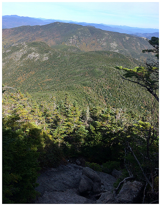
Summit of Mount Jackson
Presidential Range
Looking out toward Mount Webster with Mount Willey rising above it
Mount Carriagain off in the distance, watching over the Pemi Wilderness
Mount Willey, Field, Tom, Avalon, and Willard
Beautiful morning from Mount Jackson
Highland Center and Sacco Lake
The Crawford Notch Scenic Railroad and Mount Willard
Top of Crawford Notch
Colors starting to change in Crawford Notch
FYI - The Willard Section House was repeatedly vandalized and used for overnight stays in summer without permission, so Maine Central burned it down in 1972 when there was enough snow on the ground to prevent the fire from spreading. Here's a link to more info: http://www.bartletthistory.org/bartletthistory/crawford2.htm#mag
ReplyDeleteThanks Ron, that was a great read! I don't know why I thought it was swept away in a landslide, I might be thinking of something else in the area that was taken out by a landslide after torrential rains in the 1800's. I'll make sure to correct the error in the trip report.
DeleteWow, awesome hiking ! So jealous, live so far away. Thanks for the reports - I enjoy them. - Wendy
ReplyDeleteGlad you always enjoy the pics, Wendy. Hope you're able to get back up here soon :)
Delete