
Date of Hike: 6/20/15
Old Jackson Road: 1.6 miles / Raymond Path: 1.8 miles / Huntington Ravine Trail: 0.9 miles / Alpine Garden Trail: 0.9 miles / Lion Head Trail: 0.4 miles / Tuckerman Ravine Trail: 0.5 miles / Crawford Path: 0.5 miles / Davis Path: 0.7 miles / Camel Trail: 0.5 miles / Abandoned Crawford Bridle Path: 0.7 miles / Davis Path: 1.0 miles / Boott Spur Trail: 2.7 miles / Tuckerman Ravine Trail: 0.3 miles
Total Miles: 12.5 miles (5,325 feet elevation gained)
Trip Report:
- Saturday was a busy day on Mount Washington, the annual road race was being held and the weather was absolutely perfect so there'd be plenty of hikers out and about roaming around the rock pile for the day. To avoid the crowds Whitney and I got an early start to hike Mount Washington via Huntington Ravine, one of my favorite trails in the White Mountains. This would be Whitney's first time heading up Huntington Ravine which made me really excited for her to experience the scrambles and steep ascent up the headwall.
- On the way to Huntington Ravine we took Old Jackson Road and the Raymond Path so Whitney could get in a red-line for the Raymond Path on her way to red-lining Huntington Ravine Trail. I had been on Old Jackson Road several times and Whitney was just on it last summer during her A.T. thru-hike so this was familiar territory for both of us. After a mile and a half we hooked onto the Raymond Path, it was my first time on it as well and I really liked it as it traveled gradually uphill through dense pine woods with soft footing for the most part. It was an easy hike to the Huntington Ravine Trail junction where we banged a right and headed to the first aid cache at the floor of the ravine.
- From the first aid cache is where the fun really starts, first is the hike to the bottom of the 'Fan.' The Fan is a jumbled mess of a huge boulder field below the headwall under Pinnacle and Central Gully. To get to the Fan the trail travels through a boulder section in the scrub below it before popping out on the left side of the fan. We took a nice break at the bottom of the Fan to enjoy the views and to eat. While we were relaxing another hiker came on through, it was his first time hiking Mount Washington and he really didn't know too much about the trail, we pointed him in the right direction and he immediately went the wrong way until we again told him to follow the paint on the rocks!
- After taking our break we scurried across the fan back into the overgrown scrub section of trail up to the bottom of the first rock scramble on the headwall. Here we ran into the hiker who was again going the wrong way, this time he was headed up into Central Gully, saying the painted arrows on the rocks pointed him in that direction. Lucky for him we knew where to go and he quickly crossed over and began following us.
- The first scramble is the most difficult but extremely fun for experienced hikers. It's steep slab with a 'crack' you scramble up where you have to find hand holds in the rock to climb up. Above the first scramble are a few more that are less steep and less exposed but you still need to find good hand holds to get up. It's more of an upper body workout than most trails since you have to climb up and over ledges, especially the chimney spot before topping out. It's a lot of fun and the views get better and better as the trail gains elevation.
- Eventually the trail climbs above the ravine and reaches the Alpine Garden Trail. Whitney had to work later in the day so she headed down the Nelson Crag Trail to get in another red-line. It was too bad she had to work because it was a day to spend hours above treeline.
- I headed across the Alpine Garden to look at the flowers, I didn't notice that many, I must have been a week or two late, which usually are at their peak in early June.
- I next went up to the summit to watch some of the runners finish the road race. It was an absolute zoo at the top, cars and people everywhere. I missed the fast runners who already finished but caught the zombie runners, the people who look like they're about to fall over and pass out. Mount Washington rood race, it's just a tad hillier than the 10K pounding pavement most are used to!
- After watching a few runners I headed inside to get a bite to eat and sat in the hiker room in the basement to get away from the crowds before heading over to the Crawford Path to start my next part of the hike.
- My goal was now to head over to the Camel Trail and visit the spot where a refuge shelter stood between 1901 and 1915 until the Lakes of the Clouds Hut was erected. I had been to this spot before so I knew where to locate it, a quarter mile east of Lakes of the Clouds in a grassy knoll. I took a few pictures of what is left, a few iron wrungs sticking out of a rock, old rusted nails, and a cemented sawed off iron wrung on another rock.
- The site of this shelter was on the original cut of the Crawford 'Bridle' Path. It followed the path of least resistance for horses so it was a little longer than today's trail which after the relocation makes more of a direct approach up the summit cone. This old section of the trail curved around the rockiest parts and generally followed the alpine grass sections. The trail was outlined with boulders which can be seen in the photos below. The old section of the trail is hard to spot near the camel trail, there is a slight depression in the grass here so I was able to follow it south for a few paces then I turned around and followed it north. After about a tenth of a mile the old path becomes more obvious as it makes its way up to a small open plateau where there is a big shale rock 'beach' area it passes. From here the trail is easily visible, there is a noticeable depression in the alpine grass and it's outlined with rocks. It was really cool to be able to find and follow this part of the old Crawford Path, which had stopped being used about one hundred years ago when the trail was relocated to it's current spot which passes by Lakes of the Clouds Hut.
- The old trail pops out on the Davis Path between Tuckerman Crossover and the Camel Trail. From here I don't know if the trail continually meandered through the alpine grass or followed the present day Davis Path and Crawford Path. I guess it'll be something I'll look into next time I'm up there!
- Once back on the Davis Path I headed over to the Boott Spur for the knee hammering descent back down to Pinkham Notch. The Boot Spur Trail travels along the southern 'arm' of Mount Washington. It's sits high above Tuckerman Ravine and has tremendous views above treeline and a great outlook into the ravine from Harvard Rock. There is still plenty of rotting snow in the lower bowl of the ravine, so much so that the Tuckerman Ravine Trail is still closed through there. This isn't anything out of the ordinary as the snow takes a while to melt from the trail usually into June, sometimes July.
- Once below treeline I made decent time back to the Jeep where I beat feet back to North Conway making it through the notch before all the tourist and Story Land traffic became an issue.
- It ended up being a perfectly timed hike through some pretty cool places on Mount Washington!
Early morning on Old Jackson Road
The Raymond Path and the crossing of the Nelson Brook
On the Huntington Ravine Trail to the floor of the ravine
First open view of Pinnacle and Central Gully above the Fan
Whitney makes her way through the boulders below the fan
The trails goes under the fan, then up, comes out along the bottom left of it, crosses to the right, then heads up in the scrub along the right side of the fan to the bottom of the headwall
Bottom of Huntington Ravine as view from the Fan
Whitney enjoying the Fan
Heading through the jumbled boulder field of the Fan
Pinnacle Gully
The first scramble, steep slab, follow the arrows!
Whitney heads up the lower section of the first scramble
Scrambling on up the slab!
Taking a break above the lower part of the first scramble
Heading up the 'crack' on the upper section of the first scramble
Looking back down and across the first scramble
Whitney heads up the second scramble and looking back down the second scramble as another hiker climbs
This is one of my favorite parts, the diagonal ledge!
Whitney looks for a hand hold
Taking in the views down to Pinkham Notch. Wildcat Ridge and ski area in full view.
The last scramble of Huntington Ravine is a steep chimney, tons of fun!
Whitney makes her way up the Chimney
One last climb to the top of the chimney
Top of Huntington Ravine
Alpine Garden Trail
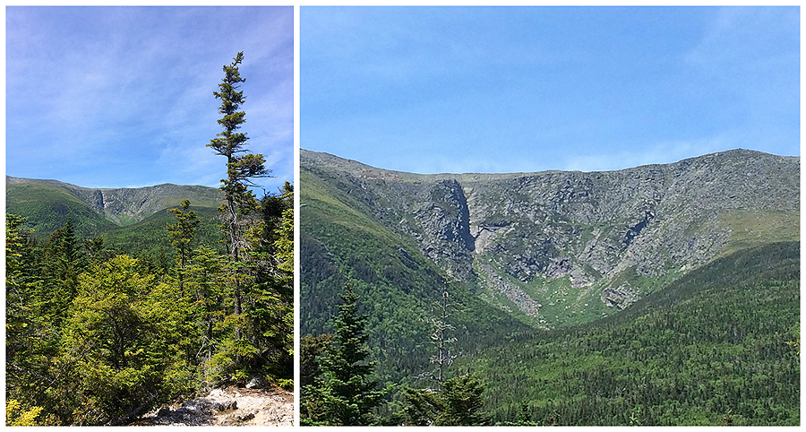
Alpine Garden Trail looking back to Huntington Ravine and across to the Boott Spur
Lion Head
Road Race 2015
It was a zoo up on Mount Washington!
Northern Presidential Range (Jefferson, Adams, Madison)
Lakes of the Clouds Hut and Mount Monroe
Southern Presidential Range
The Beautiful 'lawn' of the Davis Path
Looking back at the summit cone of Mount Washington
The Davis Path
Site of the refuge shelter
All that remains is bolted iron wrungs, rusted nails, and a sawed off cemented piece of iron
This photo is from Nicholas Howe's book Not Without Peril. The shelter was built in 1901 and stood until the Lakes of the Clouds hut was erected. It could fit around six people and was very uncomfortable but it did protect hikers from the harsh weather.
Just a few feet from where the shelter stood is a great views of Lakes of the Clouds, the hut, and Mount Monroe
Heading north on the old Crawford Path through the shale rock beach area
Here the old trail becomes more obvious as the depression in the grass is noticeable
This is where the old Crawford Path can clearly be seen, notice the depression and the rocks outlining the trail
Again, the trail is outlined with rocks on both sides
Here the old trail is about to hook into the Davis Path
Back on the Davis Path, on the right side of the photo is where the old section of the Crawford Path branched off.
Approaching the Boott Spur Trail junction
Looking back to Mount Washington from the Boot Spur
The Boot Spur Trail heads down the southern 'arm' of Mount Washington
Heading down the Boott Spur Trail with the Wildcat and Carter Range in view
A nice open plateau on the Boot Spur Trail
Tuckerman Ravine from Harvard Rock
Still plenty of snow in the ravine!
Split Rock
Irene slide from Harvard Rock
One last view of Huntington Ravine
Old ladder steps on the Boott Spur Trail
Crystal Cascade Falls
Signs from Pinkham Notch to Huntington Ravine
Signs from the Alpine Garden to Davis Path
Signs from Davis Path down the Boot Spur
Route for the day, click here for more details. The yellow is the original cut of the Crawford Path between the site where the refuge shelter stood off the Camel Trail north to the Davis Path
Wow ! I must say you and Whitney continue to inspire me to keep hiking ! Getting in shape enough for the White Mountains in early August hoping to keep pecking away at the list. Awesome trip report - you guys are fearless ! Wendy, Branford CT
ReplyDeleteThanks, Wendy! Huntington ravine is one of my favorite hikes on a nice weather day :)
ReplyDeleteHo you have a nice trip up to the Whites in August and have fun hiking some new peaks!
Hi Chris! anytime you hike Huntington Ravine, I have to send you an "are you kidding me??" I can see the "slope" from a spot on Boott Spur when we are on that trail, and with binoculars ofcourse it looks like perpendicular!! kuddos to you and Whitney!! Also liked you Adaks blog--gotta get back there---we used to take in that beautiful mountain range when our daughter was out at Syracuse U----have a great summer on the slopes and stay safe---ginnie, lunenburg, ma
ReplyDeleteNice write up, great pics. Thanks
ReplyDeleteGlad you enjoyed the report and history of the old path!
Delete