
Date of Hike: 12/15/14
Valley Way: 3.8 miles / Osgood Trail: 1.0 miles / Gulfside Trail: 0.3 miles / Airline: 0.6 miles / Lowe's Path: 0.3 miles / Gulfside Trail: 1.5 miles / Jefferson Loop 0.7 miles / Gulfside Trail & Snow Whack: 2.5 miles / Crawford Path: 1.6 miles / Monroe Loop: 0.7 miles / Crawford Path: 1.3 miles / Eisenhower Loop 0.8 miles / Crawford Path: 1.2 miles / Webster Cliff Trail: 0.2 miles / Crawford Path: 3.1 miles
Total Miles: 19.6 miles (8,550 feet elevation gained)
Trip Report:
- I took Monday off hoping that the weather would break just right for Whitney and I to get in a long hike. As the weekend wore on the weather above 4,000 feet called for clear skies, temperatures above freezing and audible wind. Perfect weather for a late fall Presidential Range traverse!
- We started hiking in the dark and in the clouds around 6:15 a.m. We instantly heated up as we ascended through and then above the clouds around 4,000 feet. When we reached treeline we were greeted with amazing undercast views of clouds below us resembling an ocean with the tops of peaks looking like islands in this ocean of clouds. It was quite the site to see throughout the day as the undercast slowly dropped in elevation revealing more and more of the mountains below while melting the snow capped pine trees as the undercast level dipped.
- Above treeline we both enjoyed the one in a million day in the Presidential Range. Other than heading up Mount Madison, there was barely any wind throughout the day. The sun was shining bright and powerful as we walked directly towards it, all alone, with the whole ridge to ourselves. We only saw other hikers on the summit cone of Washington. Every mile of our hike was just the two of us, the snow, the undercast, and jet planes leaving vapour trails in the sky!
- According to the calendar this was still officially a fall hike, however, it was full winter conditions at its finest. Almost all the rocks, roots, and boulders are now hidden beneath the snow meaning it's time for microspikes, snowshoes, and crampons depending on where you are heading. For our hike, Whitney wore her snowshoes from car to car for the entire 19.6 miles, I wore my microspikes from the car to the summit of Madison and back to the hut, then wore my snowshoes all the way until the last summit of the day, Mount Pierce, before switching back into spikes for the descent below treeline. Conditions were absolutely perfect for snowshoes between Mount Adams all the way to Mount Eisenhower, before that and after that the trails were packed down enough for light traction like microspikes.
- Instead of writing more I figure I'll let the pictures tell the story of a perfect day with perfect company on the Presidential Range, enjoy!
%2Bcopy.jpg)
Route for the day, click here for details

Early morning at treeline on the Valley Way Trail

Looking down upon an ocean of clouds from the weather warning sign on the Valley Way Trail
 The Kilkenny Range floating above the clouds to the
southwest!
southwest!

Madison Springs Hut waiting for the sun to melt away the frost and rime ice

Whitney heads up the summit cone of Mount Madison on the Osgood Trail

A thick blanket of clouds covers the Great Gulf Wilderness and Pinkham Notch with the Carters and Wildcat Ridges rising above the clouds

Approaching Mount Madison's summit

View of Mount Washington from Mount Madison

Mount Adams from Mount Madison

Looking out towards the Kilkenny Range
 Whitney heads towards Madison Springs Hut
 Mount Adams from the Osgood Trail
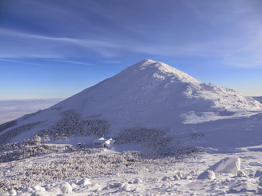 Madison Springs Hut and Mount Madison

Whitney heads up the Gulfside Trail below Mount J.Q. Adams

Whitney takes in the views on the Airline Trail up to Mount Adams

Whitney heading up the Airline Trail
 J.Q. Adams and Mount Madison
Whitney heading up the Airline Trail

Whitney ascending Mount Adams with J.Q. Adams and Mount Madison behind her

Mount Jefferson, Clay, and Washington as seen from Mount Adams
 Mount Jefferson

Whitney captures the breathtaking views on camera

Osgood Ridge blocking the wave of clouds from spilling over into the Great Gulf

Descending Lowe's Path for a few tenths of a mile
 Whitney follows the snowshoe track down from Mount Adams

Whitney scurries down Mount Adams
 Off to Mount Jefferson!

Along the Gulfside Trail towards Mount Jefferson

Looking back up the Gulfside Trail

Following day old hiking tracks in the snow
 Snow drifts and buried scrub line the Gulfside Trail
 Traveling along a winter wonderland

Mount Jefferson
 Zooming in on the Mount Jefferson snow field
 Looking towards Edmands Col
 Undercast floating around the Great Gulf Wilderness
 Heading towards Edmands Col
 Edmands Col

Snow and rime blasted trail sign in Edmands Col

Whitney ascends the steep snow field below Mount Jefferson

Jefferson Loop Trail Junction

Summit mass of Mount Jefferson looks like another planet

Whitney makes her way up the Jefferson Loop Trail
 Heading up the summit cone of Mount Jefferson
 Mount Adams as seen from the northeastern shoulder of Mount Jefferson

Six Husbands Trail Junction

Looking south towards Mount Clay, Washington, Monroe, Eisenhower, and Pierce

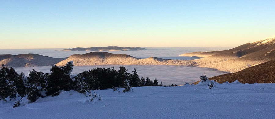
Ocean of undercast floating around the southern Presidential Range
 Bigger view of the undercast

Whitney takes in the views

Monticello Lawn

Heading south along the Gulfside Trail surrounded by Nature's snowmen

Mount Clay

Heading along the Gulfside Trail below Mount Clay
 Whitney heads up towards Mount Clay
 Looking south to the Twins and Franconia Ridge

Mountain islands

Undercast slowly dropping as the day moves along

The Cog Railway and Mount Monroe
 another shot of the cog and Mount Monroe
 Mountains slowly rising above the undercast as it drops

Whitney charges towards Mount Washington

The sun melting away the snow capped tops of trees as the undercast drops it level

Whitney with Mount Clay behind her

Northern Presidential Range

Cog Railway disappearing into the clouds

Whitney with Mount Clay, Jefferson, Adams, and Madison behind her

Making her way up towards Washington

The snow covered tracks

An tower covered in rime ice at the summit of Mount Washington

Wildcats and Carter Dome as seen from the observation tower

Summit of Mount Washington

Tip Top House

Summit area

This building needs to be chained down to protect it from the high wind speeds!

Starting the second part of the hike. Descending the Crawford Path towards Mount Monroe

Whitney heading down from the summit cone of Mount Washington

Snow fields below Mount Washignton
 Mount Washington snow filled summit cone
 Mount Monroe
Bright afternoon sun shining over the White Mountains

Approaching Mount Monroe

Lakes of the Clouds!

Lakes of the Clouds Hut

Sun hiding behind Mount Monroe
 Lakes of the Clouds and Mount Washington
 Whitney heads up the Mount Monroe Loop Trail

View from Mount Monroe's summit

Heading down from Mount Monroe

Mount Monroe and Washington peaking up behind it from Mount Franklin

'Franklin Flats' AKA Presidential Lawn

Whitney hiking and enjoying the outstanding views

Undercast blankets the Dry River Wilderness

Whitney takes off towards Mount Eisenhower

Undercast at its finest!

Looking back towards the Northern peaks of the Presidential Range

On top of the Mount Eisenhower cairn
 View of the undercast from Mount Eisenhower

Mount Eisenhower

Shadow-play

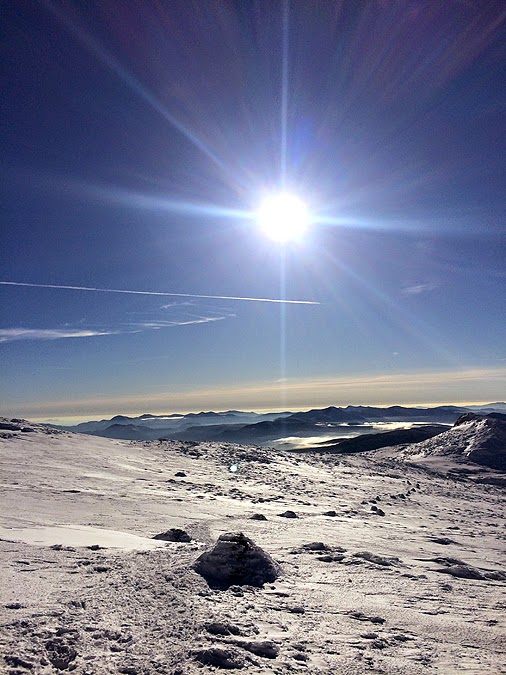
One in a million day for views!

Last presi awaits, Mount Pierce

Crawford Path southbound late in the afternoon

Pierce - Eisenhower col

Sun falling fast behind the higher peaks

Whitney on Mount Pierce
One last awesome view of the undercast form Mount Pierce
 The Presidential Range glowing in the late afternoon sun

The Presidential Range!

Back into the woods along the Crawford Path

Last stretch of hiking as night falls

The end of the day!
Awesome pictures.....wow !
ReplyDeleteThank you, glad you like the pics. It sure was a wow view filled day!
DeleteGreat trip and perfect weather... and of course great pictures! I hope this early season snow is an indicator of what winter will be like.
ReplyDeleteThanks, Mike! Hope you are enjoying the snow over in the ADK's :)
DeleteTerrific photos, what a beautiful day to be in the mountains!
ReplyDeleteThanks, Jeff. The weather was absolutely perfect for our hike!
DeleteThank you for the fantastic pictures and report. Hope to do that some day,
ReplyDeleteHope you get out there soon! Glad you enjoyed the pics, much appreciated.
DeleteThese are the most Beautiful pictures I have ever seen, what a perfect day...can't wait to get up there soon
ReplyDeleteThank you Anonymous :) Hope you get a day like Whitney and I had!
DeleteI have to agree with "anonymous". These are indeed the most fantastic pics of the White Mts I have ever seen. Fantastic job!!
ReplyDeleteThanks, Maineguy. The perfect weather and a good camera goes a long way to being able to get pictures like this. It's not so much me as it is the camera, lol! :)
DeleteWOW!!!!!!!!
ReplyDeleteCould not have scripted better weather.
Absolutely gorgeous pictures.
Climbing Pierce and Eisenhower on the 27th...extended weather is looking good...keeping the fingers crossed!
Awesome! Hope you guys have a great hike :)
Delete