
Date of Hike: 6/15/14
Valley Way: 3.8 miles / Osgood Trail: .8 miles / Gulfside Trail: .3 miles / Star Lake Trail: 1.0 miles / Lowe's Path: 0.3 miles / Gulfside Trail: 1.5 miles / Mount Jefferson Loop: .6 miles / Gulfside Trail: .7 miles / Mount Clay Loop: 1.2 miles / Gulfside Trail: .9 miles / Crawford Path: 1.8 miles / Mount Monroe Loop: .7 miles / Crawford Path: 1.3 miles / Mount Eisenhower Loop: .8 miles / Crawford Path: 1.2 miles / Webster Cliff Trail: 4.0 miles / Webster-Jackson Trail (Including Mount Webster Summit): 2.5 miles Total Miles: 23.8 (10,000 + feet elevation gained)
Trip Report:
- Sunday's forecast for Mount Washington was the following: In the clouds and fog until 9 a.m., then in and out of the clouds, under partly sunny skies, winds 25-30 mph with higher gusts. Perfect weather for a Presidential Range Traverse.
- Joining in on the hike was Tony and Kyle. Tony had done the Presi Traverse before, it would be Kyle's first. They are both really strong hikers and trail runners so it was great group to be doing a Presi Traverse with, especially since the weather forecast was absolutely wrong!
- We met in Crawford Notch at 7 a.m. where there was a light but steady rain, temps in the mid 40's, and it was windy, perfect conditions for hypothermia! Luckily, as we drove north to Appalachia the showers all but stopped as we headed up the Valley Way Trail. Temps were hovering around 50 in the woods and there was a light mist with heavy fog and clouds in the air.
- It was a quick hike up to treeline where the temperatures dropped back into the forties. Our first stop was Madison Springs Hut, where we warmed up before heading up the summit cone of Mount Madison. We all layered up and put on our windbreakers as the wind was out in full force as we started up the Osgood Trail. I had not been on the summit of Mount Madison since October with Kelsey for her first Presi Traverse. It was great to be back up the northern most peak in the Presidential Range, even if the conditions were sub-par.
- We didn't linger for long at the summit, we snapped a few pictures and rock hopped back down to the hut to heat up again. From here we had three options to summit Mount Adams. One, we could take the most popular route up the Airline via Gulfside, two, we could travel along the Gulfside to Thunderstorm Junction and 'backdoor' the summit via Lowe's Path (longest but most gradual approach), or three, we could just head up the Star Lake Trail (steepest approach). Since the wind was a factor we decided on the Star Lake Trail, once we hooked onto the trail we were out of the wind and back in t-shirts within minutes. We actually caught some great views down into Pinkham Notch but it was just a momentary clearing.
- Once we hit the summit we were back in the clouds and high winds so the jackets and hats went back on. We took a few quick pics and headed down the Lowe's Path to intercept the Gulfside Trail just south of Thunderstorm Junction.
- From here we quickly made the gradual drop over rugged terrain to the Edmands Col. We were out of the wind for about half of this trek and then got slammed again around the southern most sub peak of Mount Adams. Luckily, we were out of most of it heading up the short steep burst up from Edmands Col to the Jefferson Loop Trail.
- The wind around Jefferson's summit was pretty fierce, so we got out of the wind a little bit to refuel and warm up before heading down to Monticello Lawn and south to Sphinx Col.
- In great weather this is one of my favorite stretches in the White Mountains. You have views of Mount Adams and Jefferson behind you, the Great Gulf looms off to your left, Mount Washington's summit cone rises high above Mount Clay, which looks like a lump compared to Washington. As you cross over Mount Clay the Cog Railroad and the Southern Presidential Range come into full view. It's the first spot along the traverse where you can take in most of where you came from and all of where you are going. Unfortunately we were in the clouds for most of it so we missed out on the big views.
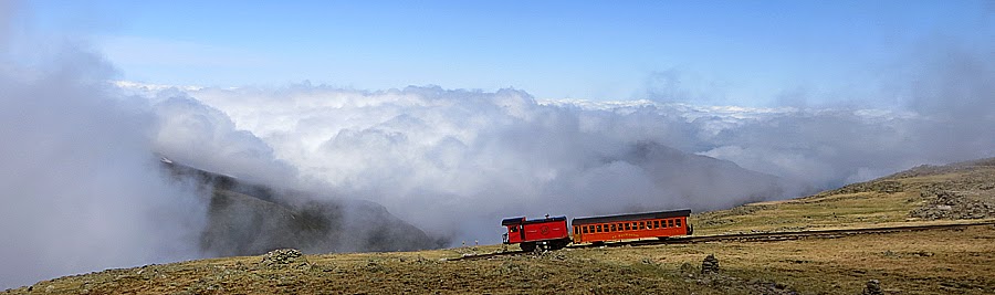
- Once past Clay we made the final push over to Mount Washington and were greeted with gusts of 60 mph plus winds a few times. I went off trail and up the tracks to get a few pics of Tony and Kyle as the Great Gulf cleared up a little bit behind them. As we crossed the tracks a train was slowly chugging up the tracks. The passengers got a pretty cool couple of minutes of clearing as they approached the summit. I think it costs close to $70 to ride the train these days, so at least the people on this ride got some cool views.
- The summit was a zoo but we were able to find a table without having to escape down to the pack room. I was happy to be out of the wind, my body runs cold and I needed about a twenty minute break to warm up and refuel. We all pigged out on disgusting cafeteria food, but when you have a craving you'll eat anything. Plus, where else can you get a hot dog on mile elevenish of a twenty-flourish mile hike??!!
- I switched out from my wind breaker to long sleeve hoody for the rock hop down to Lakes of the Clouds. This stretch of trail is 1.5 miles long, and is a rock staircase and sidewalk. The rock placement for the boulders during parts of this 1.5 mile stretch is a work of art in trail maintenance. Often you will see the hut crew jogging down the trail with an old wooden frame pack carrying around fifty pounds of gear, very impressive!
- We stopped in at the hut for a few minutes before our last adventure into the wind. Even though Mount Monroe is a thousand feet below Mount Washington, it packs a punch when it comes to wind speed. It always seems windy, and on this day it didn't disappoint. However, it was now early afternoon and the temperature was on the rise so it didn't feel as cold as earlier in the day. Mount Monroe is a pretty easy hike from the Lakes of the Clouds, it's around 0.4 miles. Once again, we didn't linger too long on the summit before heading south to Mount Franklin.
- Along the way we ran into Andrew, who I hiked with in the Great Gulf this past January. Him, his dog, and a friends stayed off the Davis Path and the night before and were doing a Davis - Crawford Path backpack. That's a pretty cool route, lots of great views along the way.
- Mount Franklin is a herd path off the Crawford Path, it's adds about fifty feet to the hike, if that, and has really great views into the Dry River Wilderness, but not on this day.
- From Franklin we motored our way south to the Eisenhower Loop Trail and then march up to the big cairn on the summit. The Clouds finally started to break on our way off Eisenhower and it started to warm up and in no time we were all in light layers again.
- The Crawford Path between Eisenhower and Pierce was a standing water / mud pit. Worst conditions I have ever seen in that stretch. Most of the bog bridges are rotted out and half submerged, they need to be replaced or the trail is going to get ripped to shreds and become wider puddles / mud pits.
- We finally got huge views from the summit of Mount Pierce. Mount Washington was still in the clouds but the rest of the range had cleared off. It was pretty cool to see how far we had came. From here, Kyle and myself kept hiking south while Tony had to jet down to the Highland Center to get back to take care of his Dog, Duke.
- Kyle set a good pace down to Mizpah Hut, where we took a ten minute break before the final stretch over to Jackson then Webster. We were back in the woods, it was warmer, and the trails were more or less a brook. Our feet were soaked but we didn't care!
- Views from Jackson were incredible, and views from Webster were even better as more clouds cleared away from the mountains.
- After enjoying the summit of Mount Webster we had the 2.5 slog back to the car. It went by quickly as Kyle recited George Carlin and Bill Cosby Lines. It made the descent over the crummy footing much more enjoyable!


Valley Way: 3.8 miles / Osgood Trail: .8 miles / Gulfside Trail: .3 miles / Star Lake Trail: 1.0 miles / Lowe's Path: 0.3 miles / Gulfside Trail: 1.5 miles / Mount Jefferson Loop: .6 miles / Gulfside Trail: .7 miles / Mount Clay Loop: 1.2 miles / Gulfside Trail: .9 miles / Crawford Path: 1.8 miles / Mount Monroe Loop: .7 miles / Crawford Path: 1.3 miles / Mount Eisenhower Loop: .8 miles / Crawford Path: 1.2 miles / Webster Cliff Trail: 4.0 miles / Webster-Jackson Trail (Including Mount Webster Summit): 2.5 miles Total Miles: 23.8 (10,000 + feet elevation gained)
Trip Report:
- Sunday's forecast for Mount Washington was the following: In the clouds and fog until 9 a.m., then in and out of the clouds, under partly sunny skies, winds 25-30 mph with higher gusts. Perfect weather for a Presidential Range Traverse.
- Joining in on the hike was Tony and Kyle. Tony had done the Presi Traverse before, it would be Kyle's first. They are both really strong hikers and trail runners so it was great group to be doing a Presi Traverse with, especially since the weather forecast was absolutely wrong!
- We met in Crawford Notch at 7 a.m. where there was a light but steady rain, temps in the mid 40's, and it was windy, perfect conditions for hypothermia! Luckily, as we drove north to Appalachia the showers all but stopped as we headed up the Valley Way Trail. Temps were hovering around 50 in the woods and there was a light mist with heavy fog and clouds in the air.
- It was a quick hike up to treeline where the temperatures dropped back into the forties. Our first stop was Madison Springs Hut, where we warmed up before heading up the summit cone of Mount Madison. We all layered up and put on our windbreakers as the wind was out in full force as we started up the Osgood Trail. I had not been on the summit of Mount Madison since October with Kelsey for her first Presi Traverse. It was great to be back up the northern most peak in the Presidential Range, even if the conditions were sub-par.
- We didn't linger for long at the summit, we snapped a few pictures and rock hopped back down to the hut to heat up again. From here we had three options to summit Mount Adams. One, we could take the most popular route up the Airline via Gulfside, two, we could travel along the Gulfside to Thunderstorm Junction and 'backdoor' the summit via Lowe's Path (longest but most gradual approach), or three, we could just head up the Star Lake Trail (steepest approach). Since the wind was a factor we decided on the Star Lake Trail, once we hooked onto the trail we were out of the wind and back in t-shirts within minutes. We actually caught some great views down into Pinkham Notch but it was just a momentary clearing.
- Once we hit the summit we were back in the clouds and high winds so the jackets and hats went back on. We took a few quick pics and headed down the Lowe's Path to intercept the Gulfside Trail just south of Thunderstorm Junction.
- From here we quickly made the gradual drop over rugged terrain to the Edmands Col. We were out of the wind for about half of this trek and then got slammed again around the southern most sub peak of Mount Adams. Luckily, we were out of most of it heading up the short steep burst up from Edmands Col to the Jefferson Loop Trail.
- The wind around Jefferson's summit was pretty fierce, so we got out of the wind a little bit to refuel and warm up before heading down to Monticello Lawn and south to Sphinx Col.
- In great weather this is one of my favorite stretches in the White Mountains. You have views of Mount Adams and Jefferson behind you, the Great Gulf looms off to your left, Mount Washington's summit cone rises high above Mount Clay, which looks like a lump compared to Washington. As you cross over Mount Clay the Cog Railroad and the Southern Presidential Range come into full view. It's the first spot along the traverse where you can take in most of where you came from and all of where you are going. Unfortunately we were in the clouds for most of it so we missed out on the big views.
- Once past Clay we made the final push over to Mount Washington and were greeted with gusts of 60 mph plus winds a few times. I went off trail and up the tracks to get a few pics of Tony and Kyle as the Great Gulf cleared up a little bit behind them. As we crossed the tracks a train was slowly chugging up the tracks. The passengers got a pretty cool couple of minutes of clearing as they approached the summit. I think it costs close to $70 to ride the train these days, so at least the people on this ride got some cool views.
- The summit was a zoo but we were able to find a table without having to escape down to the pack room. I was happy to be out of the wind, my body runs cold and I needed about a twenty minute break to warm up and refuel. We all pigged out on disgusting cafeteria food, but when you have a craving you'll eat anything. Plus, where else can you get a hot dog on mile elevenish of a twenty-flourish mile hike??!!
- I switched out from my wind breaker to long sleeve hoody for the rock hop down to Lakes of the Clouds. This stretch of trail is 1.5 miles long, and is a rock staircase and sidewalk. The rock placement for the boulders during parts of this 1.5 mile stretch is a work of art in trail maintenance. Often you will see the hut crew jogging down the trail with an old wooden frame pack carrying around fifty pounds of gear, very impressive!
- We stopped in at the hut for a few minutes before our last adventure into the wind. Even though Mount Monroe is a thousand feet below Mount Washington, it packs a punch when it comes to wind speed. It always seems windy, and on this day it didn't disappoint. However, it was now early afternoon and the temperature was on the rise so it didn't feel as cold as earlier in the day. Mount Monroe is a pretty easy hike from the Lakes of the Clouds, it's around 0.4 miles. Once again, we didn't linger too long on the summit before heading south to Mount Franklin.
- Along the way we ran into Andrew, who I hiked with in the Great Gulf this past January. Him, his dog, and a friends stayed off the Davis Path and the night before and were doing a Davis - Crawford Path backpack. That's a pretty cool route, lots of great views along the way.
- Mount Franklin is a herd path off the Crawford Path, it's adds about fifty feet to the hike, if that, and has really great views into the Dry River Wilderness, but not on this day.
- From Franklin we motored our way south to the Eisenhower Loop Trail and then march up to the big cairn on the summit. The Clouds finally started to break on our way off Eisenhower and it started to warm up and in no time we were all in light layers again.
- The Crawford Path between Eisenhower and Pierce was a standing water / mud pit. Worst conditions I have ever seen in that stretch. Most of the bog bridges are rotted out and half submerged, they need to be replaced or the trail is going to get ripped to shreds and become wider puddles / mud pits.
- We finally got huge views from the summit of Mount Pierce. Mount Washington was still in the clouds but the rest of the range had cleared off. It was pretty cool to see how far we had came. From here, Kyle and myself kept hiking south while Tony had to jet down to the Highland Center to get back to take care of his Dog, Duke.
- Kyle set a good pace down to Mizpah Hut, where we took a ten minute break before the final stretch over to Jackson then Webster. We were back in the woods, it was warmer, and the trails were more or less a brook. Our feet were soaked but we didn't care!
- Views from Jackson were incredible, and views from Webster were even better as more clouds cleared away from the mountains.
- After enjoying the summit of Mount Webster we had the 2.5 slog back to the car. It went by quickly as Kyle recited George Carlin and Bill Cosby Lines. It made the descent over the crummy footing much more enjoyable!
- We hit route 302 just over ten hours after starting. It was Kyle's first Presi Traverse, and he had a blast. It was a great day out with Tony and Kyle and I look forward to other long hikes with them in the future!
Appalachia Trailhead
Weather Warning sign on the Valley Way Trail
Tony and Kyle charging up Mount Madison
Kyle on the summit of Mount Madison
JQ Adams from the Star Lake
Star Lake
Wildcat Ridge
Carter and Wildcat Ridge
JQ Adams and Star Lake
Star Lake Trail
Tony on Mount Adams
Kyle on Mount Adams
Jefferson Loop Trail Junction
Kyle on Mount Jefferson
Heading down the Jefferson Loop Trail
Monticello Lawn
Kyle, trail running
Sphinx Col
Mount Clay Summit
Hiking along the Gulfside Trail
Walking next to the Cog Railroad
The clouds trying to clear off the Northern Presidential Range
Cog Trail
The Cog
Mount Washignton
Lakes of the Clouds
Mount Monroe Loop Trail
Mount Monroe Summit
Mount Franklin
Running down the Crawford Path
This sign is always like this!
Mount Eisenhower Summit
View from Mount Eisenhower
Running down the Eisenhower Loop Trail
Crawford Path
Kyle heading down to the Crawford Path
Awful conditions today!
A.T. Junction
Presidential Range
Mount Pierce
Mount Jackson Alpine Meadow
Mount Jackson
Mount Jackson
View from Mount Jackson
Kyle heading down the Webster-Cliff Trail
Mount Webster
Mount Monroe and Franklin
Silver Cascade
Route for the day, click here for more details
Awesome trip report! You captured some good moments and the few breaks of sunshine! It was an honor getting to 'run' my first full presi-traverse with you and Tony. I can't wait for more adventures (and hopefully better weather!)!
ReplyDeleteThanks, Kyle. It was a pleasure hiking with you, you are an incredibly strong hiker and a lot of fun to be out there on the trail with you. You and Tony made for a kick ass presi traverse. Congrats on your first Presi Traverse, here's to many more!
DeleteNice full traverse, including Jackson and Webster! Looks like the weather got better as the day went on.
ReplyDeleteThanks, Jessie! See you in a few weeks for the H2H!!
Delete