
Date of Hike: 4/12/14
Crawford Path: 3.1 miles / Webster Cliff: 0.2 miles / Crawford Path: 1.2 miles / Eisenhower Loop: 0.8 miles / Crawford Path: 1.4 miles / Monroe Loop: 0.7 miles / Crawford Path: 0.3 miles / Camel Trail: 0.6 miles / Davis Path: 2.3 miles / Crawford Path: 0.6 miles / Cog Railroad: 3.0 miles / Base Station Road: 1.5 miles / Clinton Road: 3.5 miles
Total Miles: 19.2 ( Book 5,300 feet elevation gained) (GPS 6,719 feet gain) your guess is as good as mine!!
Click Here for Trail Descriptions
Trip Report:
- Every so often the weather breaks just right making for an incredible day in the mountains. Saturday was one of those days and it ended up being a perfect spring day in the Presidential Range!
- My route for the day was to start at the Highland Center really early and just hike towards Mount Washington and wonder around, eventually making my way back to my car one way or another.
- I started just after 6 a.m., the weather was already in the low thirty's as I headed up the oldest maintained trail in the United States, the Crawford Path. The trail was packed down and it was still cold enough that microspikes worked perfectly for the ascent. Until breaking above treeline just below the summit of Mount Pierce there really isn't anything too exciting about the trail. There were still about two to three feet of snow below treeline making the trail feel like a gradual climb up a ramp.
- Once I broke above treeline I was greeted by a steady wind out of the west that was a little higher than I was expecting. Even with the steady wind I was never too cold because the temperatures were well above freezing below 5,000 feet.
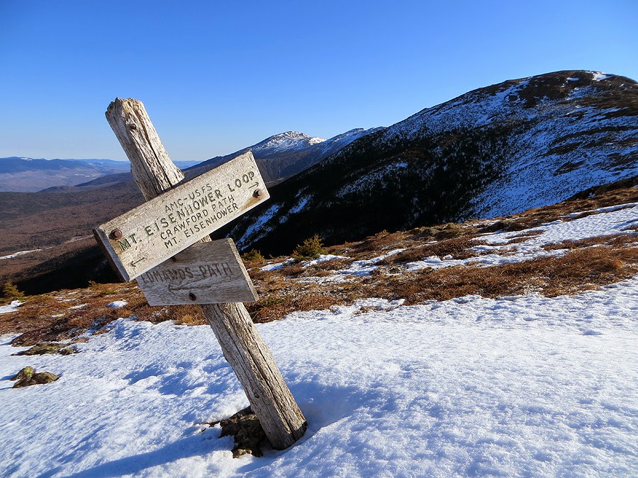
- The views above treeline were beyond phenomenal, some of the best I've had making for easy picture taking as I made my way north towards Mount Eisenhower. Above treeline the snow melts fast so there were stretches of bare rock, minimal snow, and snow drifts from the Eisenhower Loop Junction all the way to Mount Monroe.
- Along the way I got to pass one of my favorite spots in the Southern Presidential Range, a flattish grassy knob just south of Mount Franklin. It reminds me of Monticello Lawn below Mount Jefferson, I don't know if it has a name but I refer to it as the Franklin Flats.
- As I made my way to Mount Monroe I could clearly see where the Crawford Path was getting swallowed up below the eastern shoulder of Mount Monroe making for a very steep and sketchy route around the summit. Luckily, my plan was to hike over Monroe but it was cool to see the trail buried beneath a side snow slope.
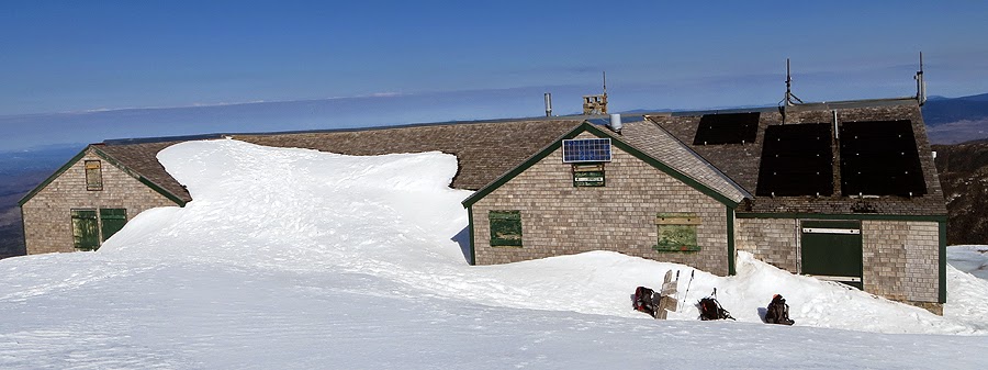
- As I started descending Mount Monroe I finally started to see hikers, they were milling around, next to, and on top of the Lakes of the Clouds Hut!
-I talked to a couple of hikers at the hut who were just as excited as me to be spending the day above treeline before I headed over to the Camel Trail to hook on the Davis Path to the Boot Spur.
- I had never been on the Camel Trail or the Davis Path in snow cover, it was a pretty memorable experience and snow capped views I had not seen before. I was happy to make this little detour before heading up the summit cone to Mount Washington's summit. The only downside was the wind was whipping around thirty miles per hour with gusts up to forty.
- As I headed south to the Boott Spur and then back north along the Davis Path I watched little black dots make their way along Lion Head then up the snowfields with skis. There is so much snow that you can ski from the snow fields along the summit, by the Alpine Garden, to the lip of Tuckerman Ravine and then shoot down. It's a pretty incredible site to see! I had thought about using the Lawn Cut-Off and head up the last part of the Tuckerman Ravine Trail but decided not too, I didn't have my crampons and eventhough my snowshoes are more than aggressive enough to handle steep stuff I wanted to coast on up to the summit without thinking.
- The final push up to Washington is strange for me, in the winter and spring it wipes me out! I don't know what it is since the footing is better than in the summer (where I have no issues) but it kicks my butt.
- Once I made it to the summit I got out of the forty plus mile and hour wind and changed my layers and refueled. My friend Stefanie reached the summit from Lion Head while I was up there, we talked about our hikes, skiing in Tuckerman Ravine, and about all the skiers in the bowl for 'Inferno Weekend.' Stefanie's boyfriend, Mike, was leading a group up Lion Head. Mike has pretty cool gig, he is a Mountain Guide and takes people up Mount Washington all the time!
- From here it was time to hike down the Cog Railroad tracks. As I started my Descent I ran into Ian and his dog Marlie who I had last hiked with for the Flags of the 48 to Flume Mountain.
- Unlike the eastern side, the western side of the mountain has significantly less snow. Still, there's enough to ski a lot of the way down and there were dozens of skiers heading up as I descended.
- Just above Jacob's Ladder I switched to my snowshoes for the extra traction needed to bite into the snow on the couple of steep sections.
- Hiking along the tracks is pretty freaking cool, there are views the whole way and it's interesting to watch the skiers head up then ski down.
- By the time I made it to the old Waumbek water tank I was in a t-shirt and getting sun burn on my shoulders as I made my way to Base Station Road. Now it was time for one of my favorite parts of hiking, where I shut my brain off when I reached Base Station Road. I walked a mile and a half down Base Station Road, then three and a half miles down Clinton Road back to the Highland Center.
- I've done this road walk in the opposite direction before and it kind of blows! This way is much easier, all downhill and very relaxing. There was enough snow cover on Clinton Road that I wasn't pounding pavement, making it much more enjoyable than usual.
- I made it back to the car around 2:30 p.m. and just hung out in the back of the Jeep, feet dangling as hikers and tourists milled around the Highland Center. Not a bad way to end the day after summiting Mount Washington for the fortieth time :)
***As a side note, my friend Whitney started her Appalachian Trail thru-hike on March 26th. She will be updating her blog with entries of her journey every so often which you can view by clicking on this link (On My Feet - Stories and Adventures of Thru-Hiking the A.T.)


Crawford Path: 3.1 miles / Webster Cliff: 0.2 miles / Crawford Path: 1.2 miles / Eisenhower Loop: 0.8 miles / Crawford Path: 1.4 miles / Monroe Loop: 0.7 miles / Crawford Path: 0.3 miles / Camel Trail: 0.6 miles / Davis Path: 2.3 miles / Crawford Path: 0.6 miles / Cog Railroad: 3.0 miles / Base Station Road: 1.5 miles / Clinton Road: 3.5 miles
Total Miles: 19.2 ( Book 5,300 feet elevation gained) (GPS 6,719 feet gain) your guess is as good as mine!!
Click Here for Trail Descriptions
Trip Report:
- Every so often the weather breaks just right making for an incredible day in the mountains. Saturday was one of those days and it ended up being a perfect spring day in the Presidential Range!
- My route for the day was to start at the Highland Center really early and just hike towards Mount Washington and wonder around, eventually making my way back to my car one way or another.
- I started just after 6 a.m., the weather was already in the low thirty's as I headed up the oldest maintained trail in the United States, the Crawford Path. The trail was packed down and it was still cold enough that microspikes worked perfectly for the ascent. Until breaking above treeline just below the summit of Mount Pierce there really isn't anything too exciting about the trail. There were still about two to three feet of snow below treeline making the trail feel like a gradual climb up a ramp.
- Once I broke above treeline I was greeted by a steady wind out of the west that was a little higher than I was expecting. Even with the steady wind I was never too cold because the temperatures were well above freezing below 5,000 feet.
- The views above treeline were beyond phenomenal, some of the best I've had making for easy picture taking as I made my way north towards Mount Eisenhower. Above treeline the snow melts fast so there were stretches of bare rock, minimal snow, and snow drifts from the Eisenhower Loop Junction all the way to Mount Monroe.
- Along the way I got to pass one of my favorite spots in the Southern Presidential Range, a flattish grassy knob just south of Mount Franklin. It reminds me of Monticello Lawn below Mount Jefferson, I don't know if it has a name but I refer to it as the Franklin Flats.
- As I made my way to Mount Monroe I could clearly see where the Crawford Path was getting swallowed up below the eastern shoulder of Mount Monroe making for a very steep and sketchy route around the summit. Luckily, my plan was to hike over Monroe but it was cool to see the trail buried beneath a side snow slope.
- As I started descending Mount Monroe I finally started to see hikers, they were milling around, next to, and on top of the Lakes of the Clouds Hut!
-I talked to a couple of hikers at the hut who were just as excited as me to be spending the day above treeline before I headed over to the Camel Trail to hook on the Davis Path to the Boot Spur.
- I had never been on the Camel Trail or the Davis Path in snow cover, it was a pretty memorable experience and snow capped views I had not seen before. I was happy to make this little detour before heading up the summit cone to Mount Washington's summit. The only downside was the wind was whipping around thirty miles per hour with gusts up to forty.
- As I headed south to the Boott Spur and then back north along the Davis Path I watched little black dots make their way along Lion Head then up the snowfields with skis. There is so much snow that you can ski from the snow fields along the summit, by the Alpine Garden, to the lip of Tuckerman Ravine and then shoot down. It's a pretty incredible site to see! I had thought about using the Lawn Cut-Off and head up the last part of the Tuckerman Ravine Trail but decided not too, I didn't have my crampons and eventhough my snowshoes are more than aggressive enough to handle steep stuff I wanted to coast on up to the summit without thinking.
- The final push up to Washington is strange for me, in the winter and spring it wipes me out! I don't know what it is since the footing is better than in the summer (where I have no issues) but it kicks my butt.
- Once I made it to the summit I got out of the forty plus mile and hour wind and changed my layers and refueled. My friend Stefanie reached the summit from Lion Head while I was up there, we talked about our hikes, skiing in Tuckerman Ravine, and about all the skiers in the bowl for 'Inferno Weekend.' Stefanie's boyfriend, Mike, was leading a group up Lion Head. Mike has pretty cool gig, he is a Mountain Guide and takes people up Mount Washington all the time!
- From here it was time to hike down the Cog Railroad tracks. As I started my Descent I ran into Ian and his dog Marlie who I had last hiked with for the Flags of the 48 to Flume Mountain.
- Unlike the eastern side, the western side of the mountain has significantly less snow. Still, there's enough to ski a lot of the way down and there were dozens of skiers heading up as I descended.
- Just above Jacob's Ladder I switched to my snowshoes for the extra traction needed to bite into the snow on the couple of steep sections.
- Hiking along the tracks is pretty freaking cool, there are views the whole way and it's interesting to watch the skiers head up then ski down.
- By the time I made it to the old Waumbek water tank I was in a t-shirt and getting sun burn on my shoulders as I made my way to Base Station Road. Now it was time for one of my favorite parts of hiking, where I shut my brain off when I reached Base Station Road. I walked a mile and a half down Base Station Road, then three and a half miles down Clinton Road back to the Highland Center.
- I've done this road walk in the opposite direction before and it kind of blows! This way is much easier, all downhill and very relaxing. There was enough snow cover on Clinton Road that I wasn't pounding pavement, making it much more enjoyable than usual.
- I made it back to the car around 2:30 p.m. and just hung out in the back of the Jeep, feet dangling as hikers and tourists milled around the Highland Center. Not a bad way to end the day after summiting Mount Washington for the fortieth time :)
***As a side note, my friend Whitney started her Appalachian Trail thru-hike on March 26th. She will be updating her blog with entries of her journey every so often which you can view by clicking on this link (On My Feet - Stories and Adventures of Thru-Hiking the A.T.)
Dawn at Mount Washington Hotel and the Presidential Range
Start of the Crawford Path, the oldest maintained trail in the United States
This little guy found some yummy garbage, so I named him Oscar
Still plenty of snow on the Crawford Path below treeline
Breaking into the scrub below Mount Pierce
Webster Cliff / Crawford Path Trail Junction, the Crawford Path now becomes part of the Appalachian Trail
Mount Pierce Summit Area
Early morning from Mount Pierce
Clouds layers above the Camel and Boott Spur
Presidential Range as seen from Mount Pierce
Along the Crawford Path
Heading to Mount Eisenhower, the trail goes in and out of the scrub
Looking back at Mount Pierce
Mount Carrigain and the Vose Spur
Mount Jackson and Webster with Mount Carrigain and the Hancocks behind it
North Twin Mountain and its slide
Eisenhower Loop Junction
Heading up the Eisenhower Loop Trail
Mount Eisenhower Summit Cairn
Descending the Eisenhower Loop Trail
Heading north to hook onto the Crawford Path again
Edmands Path / Crawford Path Trail Junction
Looking back at the 'Pleasant Dome' - Mount Eisenhower
Mount Carrigain as see from the Crawford Path
Mount Washington Hotel
Mother Nature groomed this section of trail
Lil' Monroe and Monroe with Mount Washington
Crawford Path near the 'Franklin Flats'
Heading towards Mount Franklin
Thawing out!
Mount Franklin Summit
Looking back south from Mount Franklin
Mount Monroe rising high above the Oakes Gulf
Mount Monroe, below this is the Crawford Path which just disappears into steep snow field
Mount Monroe and Washington
A lonely cairn along the Crawford Path
This used to be the Cross Cairn (it's falling apart) on the Monroe Loop Trail
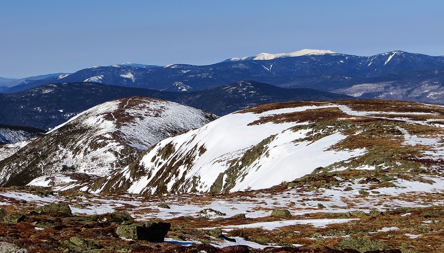
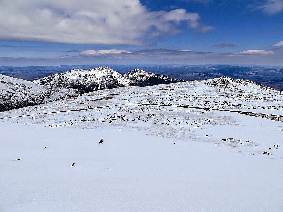
Southern Presidential Range as seen from Mount Monroe's Summit
Lakes of the Clouds Hut, lots of snow, notice the hiker roaming around the roof!
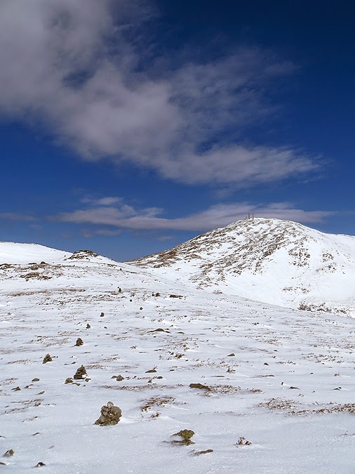
Mount Washington
Closed until June!
One sad looking dog house!
Dungeon with a view!
Frozen Solid Lakes of the Clouds
Camel Trail
Mount Monroe
Cool looking saucer cloud floating above the Presidential Range
OddCool looking cairn along the Camel Trail
Cairns marking the way along the Camel Trail
Bright sun shinning and melting the snow
Davis Path
The Big cairn on the Davis Path
Boott Spur
Perfect day high above the trees!
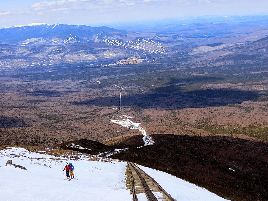
Looking south, Black Mountain ski area can be see to the far right
Wildcat Ski Area
Mount Washington
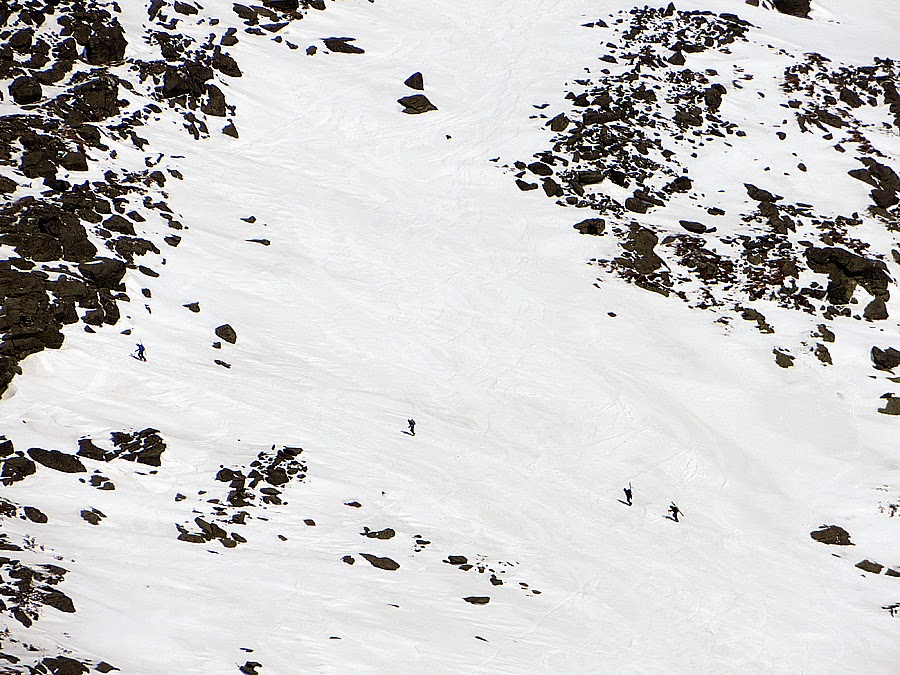
Skiers heading up the steep snow fields below Mount Washington
Mount Monroe and Mount Eisenhower
Davis Path
Skiers along Lion Head Trail heading to the 'LIP'
Heading north to Mount Washington
Skiers slowly making their way up
A line of skiers heading to the eastern snow fields
Huntington Ravine makes for a great backdrop as it dwarfs the tiny skiers marching to the summit
The Davis Path Plateau
Monroe
Lakes of the Clouds Hut getting busy
The Twin Range with the Franconia Ridge behind it
Summit tower and buildings popping up
Castle in the Clouds
Northern Presidential Range
Old telephone wire?? Mount Willey is in view here
Weather Observatory
Mount Washington 6,288
Nelson Crag Trail
Mount Adams and Madison
Cog Tracks
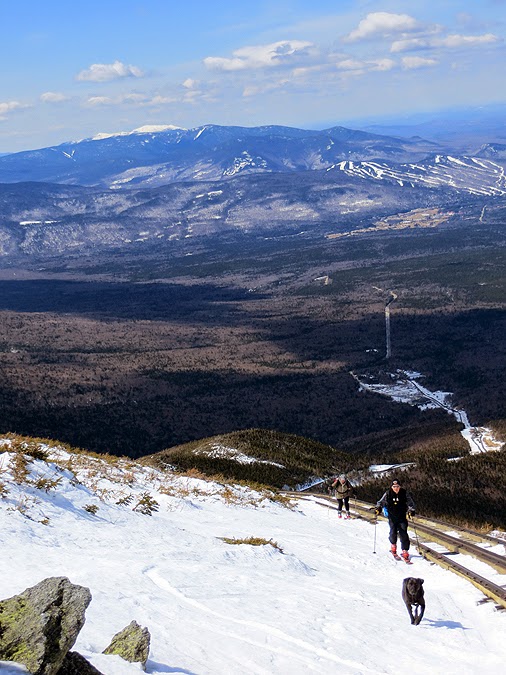
Looking back up the semi snow covered tracks
Skiers making their way up
Some places the tracks are exposed
Other places they remain burried
Dogs on the Cog Railway!
Semi steep drop off to the right, easy to walk up but a little harder to descend, I stayed to the left
Jacob's Ladder makes its first appearence
Jacob's Ladder
Hiking along the cog is a nice alternative to the trail this time of year
Jacob's Ladder marker
Skiers heading up to ski down the tracks, or Great Gulf, or down to Pinkham
Nice wide open 'road' along the tracks
Big clouds came rolling in around noonish
Tracks now above the snow for good
Looking back up to Washington's summit
Waumbek Water Tank
Final stretch of tracks above Marshfield Station
Making my way off the mountain
Brenton Woods
Looking back up one last time
Choo Choo!
The Cog Railroad
Parking lot is full!
Historical Marker
Base Station Road
Welcome to Mount Washington
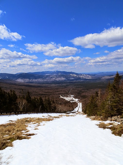
Clinton Road, it was bare in spots, light coverage in others, and...
Deep snow as the road approaches the Crawford Path and Route 302
Route 302 at the Highland Center
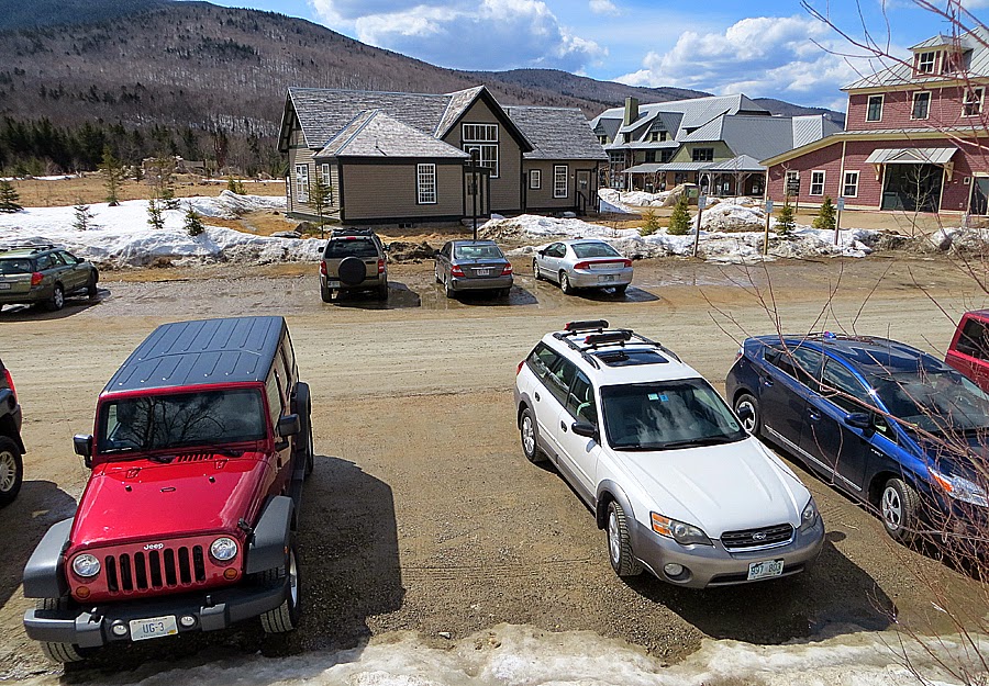
Jeep at the Highland Center
Map of my route is in red, the green is the Edmands Path, click here for more details of the hike
Envious. Looks like it was an awesome day to be up there!
ReplyDeleteThanks Rickey! It sure was a great day to spend above treeline.
DeleteWonderful pics ! Quite the hike ! Thanks for the report :) Wendy
ReplyDeleteGlad you liked the report and pics, Wendy! Hope you have some fun hikes coming up :)
DeleteThe morning light in some of the pics is fantastic.
ReplyDeleteAlways enjoy reading your posts Chris.
Thanks,
-Les
Thanks, Les. I'm glad you like the pics and the report, much appreciated. :)
Delete