
Date of Hike: 9/23/12
Hale Brook Trail: 4.4 miles
Webster-Jackson Trail: 5.2 miles
Total Miles: 9.6 (4,500 elevation gain)
Trip Report:
- Sunday Alton and I headed up to the mountains to finish hiking a round of the 48 - 4,000 together. We only had Hale and Jackson left so we decided to hike Hale first since it has no views. Originally we were going to hike the Fire Warden's Trail but rain from the night before meant we'd get soaked on the parts of the trail that were narrow so we opted for the Hale Brook Trail.
- The Hale Brook Trail was in great shape and the Birch Trees were starting to change colors and parts of the trail were blanketed with colorful leaves. Alton set a great pace which kept us warm as it was chilly out early in the morning.
- We made it to the summit a little before 10 a.m. and climb on top of the rock pile to catch some obstructed views over to the Twin Range before booking it down the mountain and over to Crawford Notch to hike up Mount Jackson.
- It was windy as we drove down Route 302 to the trailhead just past the Highland Center, so much so that Alton put on her gloves and wind breaker but within minutes of hiking in the woods she sheded her layers and we both were sweating up a storm.
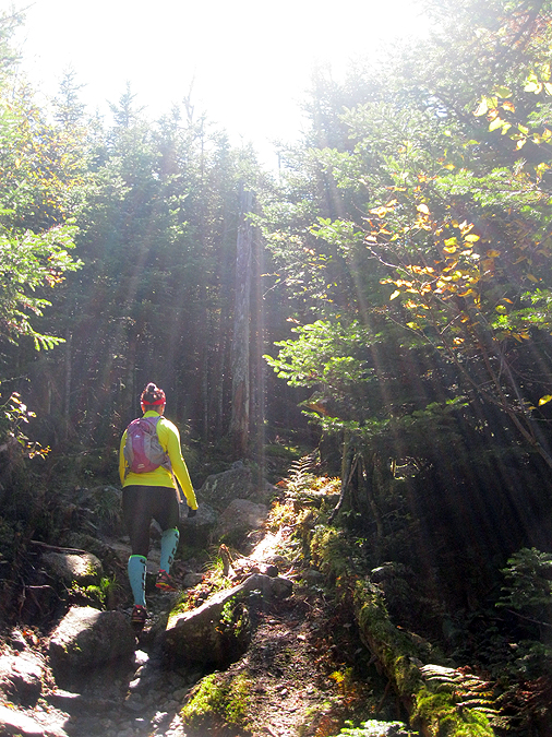
- The Webster Jackson Trail has a nice outlook overlooking Saco Lake and the Highland Center, other than that it's not really exciting until the last half mile where you get a view of the summit and the ledges below it which are a lot of fun to climb up. The trail shortly after the Webster branch of the trail is in horrific shape in a couple of spots with running water, exposed roots, and nasty rocks. luckily neither of us took a nasty fall and got off easy with just getting our sneakers muddy.
- The wind was whipping on the summit but the views were exceptional for all summits below 5,000 feet. The summits above 5,000 feet were blanketed in thick ugly clouds where it must have been hellish conditions.
- There were a couple of other hikers on the summit, a few back-packers who Alton had a little fun with telling them that it was out first hike and if they were any other mountains like this. They seemed kind of puzzled to hear that and thought we were crazy.
- Alton and I got out of the wind and enjoyed the views on our final summit of hiking the 48 - 4,000 footers together. After about fifteen minutes we both started to get chilled so we headed back down into the woods and enjoyed our hike back to the car.
- It was a fun morning and early afternoon in the White Mountains and we both were happy that we have been able to hike all 48 together. We never had the intention of doing this but in July we went over the mountains we hiked together and noticed we were well over 30 so we figured it would be fun to hike the rest of them. It's been a great bunch of hikes to get there, from our first hike in the middle of the winter back in 2011 doing an out and back of Madison, Adams, and Jefferson where we lost the trail, ran into spruce traps, and had to climb over a sub peak of Mount Adams to get back to a safe trail, to a bunch of endurance hikes like MMD, 24 Hour H2H attempt, Pemi Loop, Double Presi, to exploring some abandoned trails like the Downes Brook Slide and the old Mount Cabot trail. We lucked out with some terrific weather making for some great views and memories that will last forever!


Hale Brook Trail: 4.4 miles
Webster-Jackson Trail: 5.2 miles
Total Miles: 9.6 (4,500 elevation gain)
Trip Report:
- Sunday Alton and I headed up to the mountains to finish hiking a round of the 48 - 4,000 together. We only had Hale and Jackson left so we decided to hike Hale first since it has no views. Originally we were going to hike the Fire Warden's Trail but rain from the night before meant we'd get soaked on the parts of the trail that were narrow so we opted for the Hale Brook Trail.
- The Hale Brook Trail was in great shape and the Birch Trees were starting to change colors and parts of the trail were blanketed with colorful leaves. Alton set a great pace which kept us warm as it was chilly out early in the morning.
- We made it to the summit a little before 10 a.m. and climb on top of the rock pile to catch some obstructed views over to the Twin Range before booking it down the mountain and over to Crawford Notch to hike up Mount Jackson.
- It was windy as we drove down Route 302 to the trailhead just past the Highland Center, so much so that Alton put on her gloves and wind breaker but within minutes of hiking in the woods she sheded her layers and we both were sweating up a storm.
- The Webster Jackson Trail has a nice outlook overlooking Saco Lake and the Highland Center, other than that it's not really exciting until the last half mile where you get a view of the summit and the ledges below it which are a lot of fun to climb up. The trail shortly after the Webster branch of the trail is in horrific shape in a couple of spots with running water, exposed roots, and nasty rocks. luckily neither of us took a nasty fall and got off easy with just getting our sneakers muddy.
- The wind was whipping on the summit but the views were exceptional for all summits below 5,000 feet. The summits above 5,000 feet were blanketed in thick ugly clouds where it must have been hellish conditions.
- There were a couple of other hikers on the summit, a few back-packers who Alton had a little fun with telling them that it was out first hike and if they were any other mountains like this. They seemed kind of puzzled to hear that and thought we were crazy.
- Alton and I got out of the wind and enjoyed the views on our final summit of hiking the 48 - 4,000 footers together. After about fifteen minutes we both started to get chilled so we headed back down into the woods and enjoyed our hike back to the car.
- It was a fun morning and early afternoon in the White Mountains and we both were happy that we have been able to hike all 48 together. We never had the intention of doing this but in July we went over the mountains we hiked together and noticed we were well over 30 so we figured it would be fun to hike the rest of them. It's been a great bunch of hikes to get there, from our first hike in the middle of the winter back in 2011 doing an out and back of Madison, Adams, and Jefferson where we lost the trail, ran into spruce traps, and had to climb over a sub peak of Mount Adams to get back to a safe trail, to a bunch of endurance hikes like MMD, 24 Hour H2H attempt, Pemi Loop, Double Presi, to exploring some abandoned trails like the Downes Brook Slide and the old Mount Cabot trail. We lucked out with some terrific weather making for some great views and memories that will last forever!
Hale Brook
Hale Brook Trail
Mount Hale rock pile
Hiking down the Hale Brook Trail
Leaves starting to cover the trail
Autumn is here on the Hale Brook Trail
Alton making here way to the end of the trail
Alton on the Webster-Jackson Trail
Awful footing on the Jackson branch of the Webster-Jackson Trail
Just below the summit ledge
Mount Tom, Field, and Willey
Alton climbing up the ledges to the summit of Mount Jackson
View to the southwest from the summit of Mount Jackson
Mount Carrigain
Mount Willey
Mount Jackson Summit
Brenton Woods
Mount Washington Hotel
Southern Presidential Range
Mizpah Springs Hut, Mount Pierce and Eisenhower
Dry River Wilderness
Mizpah Springs Hut and Mount Pierce
Summit of Mount Jackson
Alton descending the ledge below Mount Jackson
Alton hopping down the rock slab
Webster-Jackson Trail
Alton heads 'Into the Light'
Little Mossy Brook
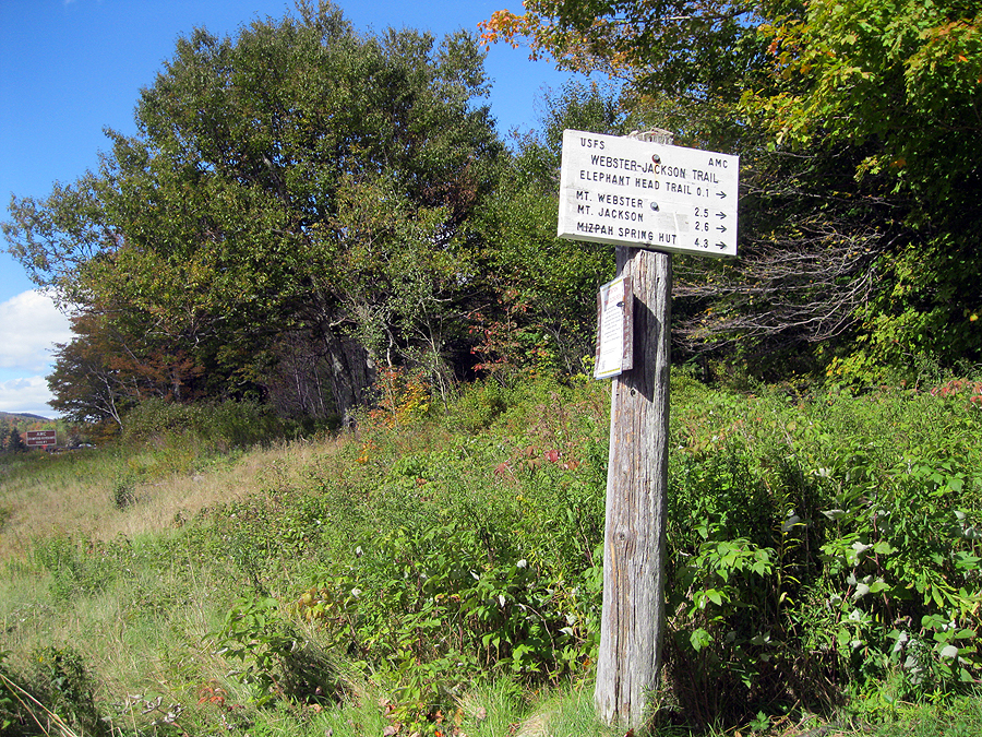
Webster-Jackson trailhead
Route 302 at the top of Crawford Notch
Highland Center


