
Date of Hike: 9/8/12
Lake Road: 3.8 miles
|
Alfred W. Weld Trail: 2.8 miles
|
ADK Range Trail: 3.5 miles
|
Bennies Brook Slide: 1.7 miles
|
Southside Trail: 2.7 miles
|
Phelps Trail: 0.5 miles
|
Total Miles: 15.0 miles
|
5,000 feet elevation gain
|
Trip Report:
- It was finally time to head back to the Adirondacks and hike with my roommate from 'The College of the Quinnipiac University' - Tom 'The Captain' Diaz for a Lower Great Range Traverse.
- The weather could not have been any better, mostly sunny with high puffy clouds and a light wind with temps in the high 60's to low 70's which made for some great views of the High Peaks.
- We dropped one car off at the Garden trailhead then headed to Ausable Club in St. Huberts and were off hiking down the private Lake Road early in the morning.
- We made good time to the Lower Ausable dam where we hooked onto the Alfred W. Weld Trail, the first part of the trail until the Sawteeth/Pyramid col has decent footing for most of it's length but has no views at all. The highlight of the trail is actually a side trail that leads you to the bottom of Rainbow Falls, which is huge waterfall that spills over the top of a magnificent vertical cliff.
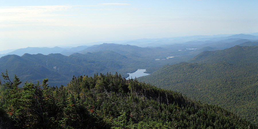
- Once past the Sawteeth/Pyramid Col the trail become steep and the footing becomes supbar as we made our way to Pyramid Peak. Views from Pyramid Peak are some of the best in the Adirondacks, close up views of the slides of Gothics and Basin Mountains.
- We took a nice long break and enjoyed the views of the Great Range while refueling before heading to Gothics. The hike from Pyramid Peak to Gothics is two short bursts, an up and down that are extremely steep but we made good time after our long break so it didn't tire us out at all.
- Gothics is my favorite mountain in the Adirondacks, the approaches and the views are some of the best around. We took another decent break on Gothics before heading onto phase two of the hike Armstrong through Lower Wolfjaw.
- The hike to Armstrong Mountain is pretty tame, barely enough elevation loss and gain for it to count as an official 4,000 footer. As we summited Armstrong we ran into two hikers I know from the White Mountains, Karine and Jeff, they had spent the past week hiking all over the ADK's and were ending their trip in grand fashion as they were in the middle of a one day Great Range Traverse (Rooster Comb through Marcy)! Great seeing you guys again!
- Diaz and I took in the last great views of the Great Range from Armstrong before heading over to Upper and Lower Wolfjaw. The descent off of Armstrong to the col between Upper Wolfjaw is pretty nasty, it's steep with rough footing and there is an old ladder on one part to help hikers navigate the trail safely. I was kind of drained at this point, mostly from the 400 miles of driving I did the day before and the 90 minutes of sleep we both got the night before in the hostel that was full of snorers!
- However the hike from the col to Upper Wolfjaw isn't too bad so we bounced back and were at the summit pretty quickly where we were greeted by a mouse looking for some free food.
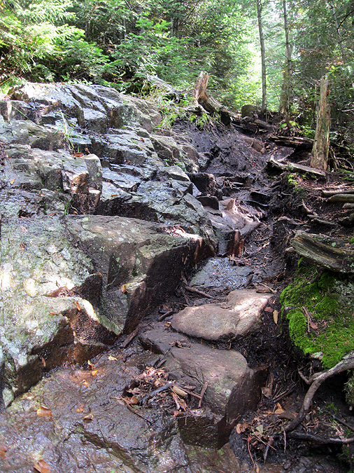
- Now it was for the worst part of our hike, the descent down to Wolfjaw Notch and then the relentless steep ascent up to Lower Wolfjaw. It's not fun, it's in the woods and footing for the most part is rough, the only thing that kept our spirits up was that it was the last up of the day and once past the summit we were going to descend via Bennies Brook Slide so we would be rewarded with a fun slide hike with killer views.
- It took us awhile but we made it to Lower Wolfjaw with no issues and we were greeted by another mouse looking for food as we took a nice long break to relax and refuel before heading down from the range.
- Back in June I hiked up the Bennies Brook slide and loved it, I made sure to note where I bushwhacked from the slide to the trail so I would know where to go if I jumped on the slide from the ridge. Unfortunately my memory isn't quite as good as I thought as I almost brought us out onto the top of the slide at first, I cut into the woods way to early, so we backtracked and we went down a very steep section of trail and BAM! there was a very well defined herd path on the left leading to the safer part of the slide.
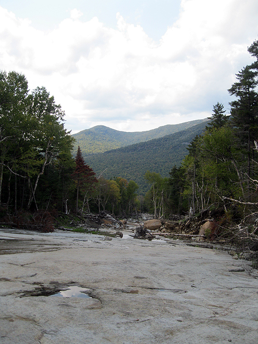
- The slide is a beginner's slide, it's not very steep, it's very wide, and easy to navigate. I found it faster to hike up it simply because when descending the views are spectacular and the destruction left behind from Hurricane Irene is out of this world!
- About two-thirds of the way down the slide we both had had enough of the slide hiking and were looking forward to dirt and mud of the Southside Trail. Once on the Southside Trail we quickly made our way back to the Garden trailhead, jumped into the car retrieve Diaz's car at the Ausable Club trailhead, headed back to the hostel before heading out for well deserved dinner and drinks capping off a great day in the Great Range!


- It was finally time to head back to the Adirondacks and hike with my roommate from 'The College of the Quinnipiac University' - Tom 'The Captain' Diaz for a Lower Great Range Traverse.
- The weather could not have been any better, mostly sunny with high puffy clouds and a light wind with temps in the high 60's to low 70's which made for some great views of the High Peaks.
- We dropped one car off at the Garden trailhead then headed to Ausable Club in St. Huberts and were off hiking down the private Lake Road early in the morning.
- We made good time to the Lower Ausable dam where we hooked onto the Alfred W. Weld Trail, the first part of the trail until the Sawteeth/Pyramid col has decent footing for most of it's length but has no views at all. The highlight of the trail is actually a side trail that leads you to the bottom of Rainbow Falls, which is huge waterfall that spills over the top of a magnificent vertical cliff.
- Once past the Sawteeth/Pyramid Col the trail become steep and the footing becomes supbar as we made our way to Pyramid Peak. Views from Pyramid Peak are some of the best in the Adirondacks, close up views of the slides of Gothics and Basin Mountains.
- We took a nice long break and enjoyed the views of the Great Range while refueling before heading to Gothics. The hike from Pyramid Peak to Gothics is two short bursts, an up and down that are extremely steep but we made good time after our long break so it didn't tire us out at all.
- Gothics is my favorite mountain in the Adirondacks, the approaches and the views are some of the best around. We took another decent break on Gothics before heading onto phase two of the hike Armstrong through Lower Wolfjaw.
- The hike to Armstrong Mountain is pretty tame, barely enough elevation loss and gain for it to count as an official 4,000 footer. As we summited Armstrong we ran into two hikers I know from the White Mountains, Karine and Jeff, they had spent the past week hiking all over the ADK's and were ending their trip in grand fashion as they were in the middle of a one day Great Range Traverse (Rooster Comb through Marcy)! Great seeing you guys again!
- Diaz and I took in the last great views of the Great Range from Armstrong before heading over to Upper and Lower Wolfjaw. The descent off of Armstrong to the col between Upper Wolfjaw is pretty nasty, it's steep with rough footing and there is an old ladder on one part to help hikers navigate the trail safely. I was kind of drained at this point, mostly from the 400 miles of driving I did the day before and the 90 minutes of sleep we both got the night before in the hostel that was full of snorers!
- However the hike from the col to Upper Wolfjaw isn't too bad so we bounced back and were at the summit pretty quickly where we were greeted by a mouse looking for some free food.
- Now it was for the worst part of our hike, the descent down to Wolfjaw Notch and then the relentless steep ascent up to Lower Wolfjaw. It's not fun, it's in the woods and footing for the most part is rough, the only thing that kept our spirits up was that it was the last up of the day and once past the summit we were going to descend via Bennies Brook Slide so we would be rewarded with a fun slide hike with killer views.
- It took us awhile but we made it to Lower Wolfjaw with no issues and we were greeted by another mouse looking for food as we took a nice long break to relax and refuel before heading down from the range.
- Back in June I hiked up the Bennies Brook slide and loved it, I made sure to note where I bushwhacked from the slide to the trail so I would know where to go if I jumped on the slide from the ridge. Unfortunately my memory isn't quite as good as I thought as I almost brought us out onto the top of the slide at first, I cut into the woods way to early, so we backtracked and we went down a very steep section of trail and BAM! there was a very well defined herd path on the left leading to the safer part of the slide.
- The slide is a beginner's slide, it's not very steep, it's very wide, and easy to navigate. I found it faster to hike up it simply because when descending the views are spectacular and the destruction left behind from Hurricane Irene is out of this world!
- About two-thirds of the way down the slide we both had had enough of the slide hiking and were looking forward to dirt and mud of the Southside Trail. Once on the Southside Trail we quickly made our way back to the Garden trailhead, jumped into the car retrieve Diaz's car at the Ausable Club trailhead, headed back to the hostel before heading out for well deserved dinner and drinks capping off a great day in the Great Range!
Ausable Club Parking Lot
Giant Mountain
Sawteeth
Ausable Club
Ausable Golf Course
Lake Road Security Building
Lake Road Gate
Old Dam along Lake Road
Lower Ausable Dam
Trail to Sawteeth and Pyramid
Lower Ausable Lake
Early morning at Lower Ausable Lake
Rainbow Falls
 Fnny but true sign at the Ranbow Falls downlook
 Rainbow Falls
Alfred W. Weld Trail
Giant and Rocky Peak Ridge from the Alfred W. Weld Trail
Diaz scrambling up a rock on the Alfred W. Weld Trail
Basin from Pyramid
Gothics from Pyramid
Haystack from Pyramid
Allen from Pyramid
Pinnacle Ridge (Clovin and Blake Peak) with Nippletop behind it
Diaz enjoying the views from Pyramid Peak
Basin, Saddleback, and Gothics
Saddleback Mountain
Basin Mountain with Marcy behind it
Pinnacle Ridge and Upper Ausable Lake
On Pyramid Peak
Alfred W. Weld Trail to Gothics
Gothics and Armstrong
Diaz descending Pyramid Peak
Pyramid Peak from Gothics
Diaz conquering Gothics
Big Slide and John's Brook Valley
Big Slide Mountain
Upper Great Range
Orebed Brook and Saddleback Slide
Wright, Algonquin, Iroquois, and Colden from Gothics
Gothics Summit Marker
Lower Ausable Lake
Newt!
Only Flat section of the ADK Range Trail!
Armstrong / Gothics Col
The Great Range from Armstrong
Diaz descending Armstrong
Diaz navigating down an old ladder
Lower Wolfjaw from Upper Wolfjaw
Nippletop with Dix behind it
Adk Range Trail sign info
 |
Lower Wolfjaw from a sub-peak of Upper Wolfjaw
ADK Range Trail
Diaz about to make a leap of faith
Wolfjaw Notch
ADK Range Trail
Dogs on Wolfjaw!
Orebed Brook Slide
Lower Wolfjaw Summit
Bennies Brook Slide herd path starts here on the left
Top of Bennies Brook Slide
Johns Brook Valley
Upper section of the Bennies Brook Slide
Looking down the Bennies Brook Slide
Bennies Brook Slide
Diaz hopping from step to step down the slide
Diaz in a mud zone section of the slide
Bennies Brook Slide
Bennies Brook Slide
Diaz on a huge slab section on the slide
Looking up the Bennies Brook Slide
Diaz approaching another mud section of the slide
Fork in the slide, old slide goes up and to the left
Bennies Brook Slide and Lower Wolfjaw
Diaz enjoying the slide
The beginning of a cascade / waterfall
Bennies Brook Cascade
Bennies Brook Slide
Bennies Brook Slide
Interesting slab step formations on the slide
Bennies Brook Slide
Heading toward the lower section of the slide
Bennies Brook Slide
Looking back up the slide

Bumble Bee!
Long stretch of slab on the slide
Descending a slab section
Diaz navigating through a rocky section of the slide
Lower part of the slide
Lower section of the Bennies Brook Slide
Heading toward John's Brook
Bennies Brook
Lower section of the slide
Into the woods along the slide
Diaz jumping down from the Bennies Brook Slide
Cool Little waterfall randomly coming from the woods
Diaz at the end of the Bennies Brook Slide
Looking down the end of the Bennies Brook Slide
Bennies Brook Slide from the Southside Trail
Old ADK Trail marker
Damaged section of the Southside Trail (on the right the trail drops off a cliff into the water, on the left is a ladder to help you down to the river)
Diaz navigating his was through Johns Brook
Southside Trail
Johns Brook
Diaz crossing Johns Brook
Southside Trail
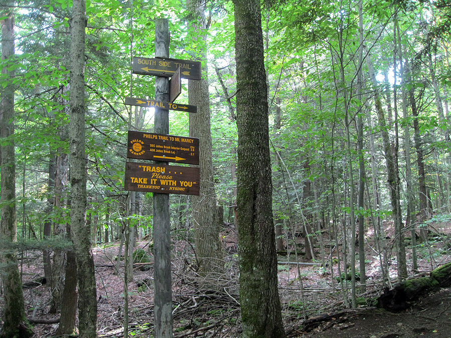
Phelps / Southside Trail Junction
Phelps Trail
The Garden
Chris, that slide looks like a tremendous amount of fun!
ReplyDeleteIt sure is, it's wide open and not steep at all and the views are great, hope the Lincoln Slide is that much fun!!
DeleteNice trip report and great pics! Looks like we'll have to return to do Bennie's Brook Slide... looks awesome. We'll be back in the area for Sawteeth anyways and I definitely wanted to revisit Gothics. What a mountain! Was nice running into you guys on Armstrong and thanks again for your advice and your ADK 46R trip reports which were all very helpful in our planning. Impressed that you did the GRT with Marcy first - not sure my legs would have wanted all that up/down so late in the day - but I guess it's a pretty nice descent from Rooster Comb and the last few miles would be a little more interesting than the 9 miles down/out from Marcy. As for everything in between - for every climb that would be easier in the opposite direction, there's a descent that would be tougher, so not sure there is an obvious "best" direction. It's just a killer hike no matter how you look at it. ;) See you around the Whites.
ReplyDeleteBest,
Karine
Hey Karine,
DeleteThat Great Range Traverse is a blast, I'm going to have to try it the way you guys did, descending the cliffs of Saddleback seems a lot more nerver-racking than ascending them, then you get that back breaking Basin to Haystack section, and I think I'd go a little crazy (Lincoln Woods / Wilderness Trail style) on the long nine mile walk back down from Marcy, job well done!! Enjoy your next trip to the Dak's, and I'll keep my eye out for you and Jeff on the trails in the Whites :)!!