
Date of Hike: 11/2/13
Mount Mitchell Trail: 12.0 miles (3,700 feet elevation gain)
Trip Report:
- Last year Blindt and I made plans to hike Mount Mitchell with Alton, but a freak early fall snowstorm cancelled those plans. Luckily, this year the weather was more seasonal so Blindt and I headed to the Black Mountain Range to hike the highest mountain east of the Mississippi at 6,684 feet.
- The drive up to the trailhead was one of the more thrilling ones, the road narrowly winds up two sides of a ravine deep in the woods along switchbacks with some steep drop-offs!
- The description of the trail in the guidebook said it climbs steeply and was very rough. However, that was completely inaccurate, the trail was a constant gentle ramp like walk with many long switchbacks, the difficulty was similar to hiking to Lonesome Lake or the lower half of the Valley Way.
- The bottom of the trail traveled through a nice open hardwood forest, the middle of the trail went through a narrow rhododendron lined path, the upper section went up an old growth balsam woods.
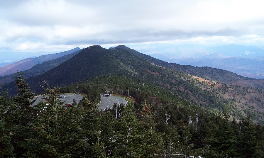
- The summit has a really nice outlook where we took some pictures before stopping in at the rangers cabin to warm up and talk to the ranger.
- As we headed down we ran into well over a dozen people. We timed the hike perfectly as a big black storm cloud hovered over the peak as we finished.
- It was a great little hike with my old 'College of the Quinnipiac University' buddy, Brandon Blindt. Blindt had a huge impact in getting me back into hiking again in my late twenty's when he invited me to hike Mount Katahdin and since then I've never looked back. Blindt used to live in NH but now lives in NC with his wife Danielle and his two and a half year old boy Beau! It's always a great road trip to visit the three of them and fun to catch up with Blindt and talk about hiking!


Mount Mitchell Trail: 12.0 miles (3,700 feet elevation gain)
Trip Report:
- Last year Blindt and I made plans to hike Mount Mitchell with Alton, but a freak early fall snowstorm cancelled those plans. Luckily, this year the weather was more seasonal so Blindt and I headed to the Black Mountain Range to hike the highest mountain east of the Mississippi at 6,684 feet.
- The drive up to the trailhead was one of the more thrilling ones, the road narrowly winds up two sides of a ravine deep in the woods along switchbacks with some steep drop-offs!
- The description of the trail in the guidebook said it climbs steeply and was very rough. However, that was completely inaccurate, the trail was a constant gentle ramp like walk with many long switchbacks, the difficulty was similar to hiking to Lonesome Lake or the lower half of the Valley Way.
- The bottom of the trail traveled through a nice open hardwood forest, the middle of the trail went through a narrow rhododendron lined path, the upper section went up an old growth balsam woods.
- The summit has a really nice outlook where we took some pictures before stopping in at the rangers cabin to warm up and talk to the ranger.
- As we headed down we ran into well over a dozen people. We timed the hike perfectly as a big black storm cloud hovered over the peak as we finished.
- It was a great little hike with my old 'College of the Quinnipiac University' buddy, Brandon Blindt. Blindt had a huge impact in getting me back into hiking again in my late twenty's when he invited me to hike Mount Katahdin and since then I've never looked back. Blindt used to live in NH but now lives in NC with his wife Danielle and his two and a half year old boy Beau! It's always a great road trip to visit the three of them and fun to catch up with Blindt and talk about hiking!
Winter Trailhead
Gate to the campground is closed November 1st so it's another quarter or mile or so to the trailhead
Mount Mitchell Trail
Early morning sun shining through the beautiful hardwoods
Narrow rhododendron line trail
Tunnel section of the trail
Nice little campsite with a view
Mount Mitchel Trail
Old growth forest near the summit
Slant Rock
Summit of Mount Mitchell
View to the south
Summit Outlook
View to the north
Northwest ridge
View to the west
Foliage!
Summit outlook
Summit plaque
Looks Cool!
ReplyDeleteGreat pictures. Did you find Mt. Mitchell an easier climb than Katahdin?
ReplyDeleteI found Mount Mitchell to be easier than every mountain I have climbed in the northeast. Mount Mitchell is a stroll along a nice path with easy grades and good footing while Katahdin is steep, has knee hammering rocks, and has no fall zones along the Knife Edge and Cathedral trails!
Delete