Date of Hike: 11/4/17
Great Gulf Trail & Sphinx Trail: 13.0 miles (3,550 feet elevation gained)
Trip Report
- After October 30th's storm (click here for storm recap) it was time to head deep into the Great Gulf and assess the damage on my adopted trail, the Sphinx. I really didn't know what to expect, and did not know if I would be able to even reach it, as there is a section of the Great Gulf Trail near the old site of the Great Gulf Shelter that I was worried would be filled with blowdowns and would impede my travel.
- Luckily, the Great Gulf Trail was in great shape. There was one blockage between the Madison Gulf Trail junction and Clam Rock, which was removed by the time I hiked out, and between the Chandler Brook Trail junction and the Sphinx Trail junction there were about two dozen new blowdowns, half step overs and about half that could be walked under once I trimmed back the hanging branches, so other than minor annoyances the trail was in good shape for a wilderness trail.
- When I turned onto the Sphinx I was greeted with a huge problem at the first water crossing a few hundred yards up the trail. The crossing was blocked by a large pine tree which had taken out two other decent sized pine trees, an old birch, and an old rotted tree. This whole mess fell right across where the trail crosses the Clay Brook, creating a logged jam dam. It didn't know where to start on this one so I dropped down into the brook, carefully crossed, bushwhacked around the blowdown patch, and continued up the trail to assess other damage before making my way back down on the way out to see what if anything I could do here.
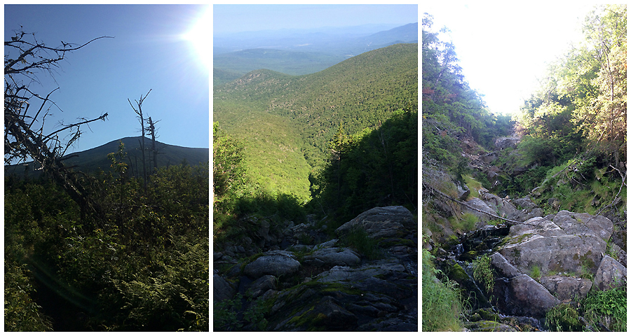
- The hike up to treeline went much better than expected, there were three other blowdowns to remove, two easy and one difficult. The difficult one was set on top of a boulder slanting down across the trail into the ground, after clipping and sawing the branches away, I used gravity to my advantage and dropped the pine into the trail where it snapped just enough so I could then rock it back and forth down the trail and out of the way.
- Further up the the trail, at the landslide from 2011 Hurricane Irene, I was relieved to see that it did not have any further damage other than a medium sized pine that became undermined and fell onto the top of the slide. Higher up the trail there were small hanging branches here and there to remove along with regular trimming that I had on my to-do list.
- Once popping above treeline I found a nice rock to take a break on before heading back down to see what I could do about the Clay Brook mess.
- When I reached the blowdown patch, I carefully poked around until I was confident that I would not be putting myself in any danger removing branches and clearing a path to go under and over these blowdowns.
- I tackled the source of the mess first, the big pine tree, by removing the branches underneath it that were blocking the trail, next I cleared the branches of the two medium sized pines, luckily these pines were laying on the trail, so there was no worry of these moving on me, I cleared the branches sticking up clearing a path to walk over these pines. This took me right to the river bank where there is a boulder, amazingly there was still a small four rock cairn on top of this boulder, the blowdowns fell all around this cairn but missed it by inches!
- From here I carefully cleared a path on top of the pines across the river, removing branches, making it able to cross using extreme caution. The forest service will have to come in and remove all this soon, or if they don't get out here maybe a winter storm will clear this log jammed dam out or make it worse, we shall see!
- Good news is the only hikers who use the Sphinx between November and late May are hardy souls who know this trail quite well.
- For those of you who have never been on this gem of a trail, check it out on a nice summer day in 2018, it's wild, rough, beautiful, and has a very secluded feeling to it!


Great Gulf Trail & Sphinx Trail: 13.0 miles (3,550 feet elevation gained)
Trip Report
- After October 30th's storm (click here for storm recap) it was time to head deep into the Great Gulf and assess the damage on my adopted trail, the Sphinx. I really didn't know what to expect, and did not know if I would be able to even reach it, as there is a section of the Great Gulf Trail near the old site of the Great Gulf Shelter that I was worried would be filled with blowdowns and would impede my travel.
- Luckily, the Great Gulf Trail was in great shape. There was one blockage between the Madison Gulf Trail junction and Clam Rock, which was removed by the time I hiked out, and between the Chandler Brook Trail junction and the Sphinx Trail junction there were about two dozen new blowdowns, half step overs and about half that could be walked under once I trimmed back the hanging branches, so other than minor annoyances the trail was in good shape for a wilderness trail.
- When I turned onto the Sphinx I was greeted with a huge problem at the first water crossing a few hundred yards up the trail. The crossing was blocked by a large pine tree which had taken out two other decent sized pine trees, an old birch, and an old rotted tree. This whole mess fell right across where the trail crosses the Clay Brook, creating a logged jam dam. It didn't know where to start on this one so I dropped down into the brook, carefully crossed, bushwhacked around the blowdown patch, and continued up the trail to assess other damage before making my way back down on the way out to see what if anything I could do here.
- The hike up to treeline went much better than expected, there were three other blowdowns to remove, two easy and one difficult. The difficult one was set on top of a boulder slanting down across the trail into the ground, after clipping and sawing the branches away, I used gravity to my advantage and dropped the pine into the trail where it snapped just enough so I could then rock it back and forth down the trail and out of the way.
- Further up the the trail, at the landslide from 2011 Hurricane Irene, I was relieved to see that it did not have any further damage other than a medium sized pine that became undermined and fell onto the top of the slide. Higher up the trail there were small hanging branches here and there to remove along with regular trimming that I had on my to-do list.
- Once popping above treeline I found a nice rock to take a break on before heading back down to see what I could do about the Clay Brook mess.
- When I reached the blowdown patch, I carefully poked around until I was confident that I would not be putting myself in any danger removing branches and clearing a path to go under and over these blowdowns.
- I tackled the source of the mess first, the big pine tree, by removing the branches underneath it that were blocking the trail, next I cleared the branches of the two medium sized pines, luckily these pines were laying on the trail, so there was no worry of these moving on me, I cleared the branches sticking up clearing a path to walk over these pines. This took me right to the river bank where there is a boulder, amazingly there was still a small four rock cairn on top of this boulder, the blowdowns fell all around this cairn but missed it by inches!
- From here I carefully cleared a path on top of the pines across the river, removing branches, making it able to cross using extreme caution. The forest service will have to come in and remove all this soon, or if they don't get out here maybe a winter storm will clear this log jammed dam out or make it worse, we shall see!
- Good news is the only hikers who use the Sphinx between November and late May are hardy souls who know this trail quite well.
- For those of you who have never been on this gem of a trail, check it out on a nice summer day in 2018, it's wild, rough, beautiful, and has a very secluded feeling to it!
The hike into the Sphinx Trail is over five miles, passing by some really nice waterfalls and cascades along the way
I call this Weetamoo Cascade, this is different from Weetamoo Falls, which is the one just past the Sphinx Trail junction
Here is the blowdown patch across the Clay Brook
Looking at the blowdown patch, which has created a log jammed damn
After carefully crossing the brook, I find the trail and see how it just comes to an end at the jumbled mess of blowdowns
I start clipping and sawing off branches to create a path under the main blowdown
After passing under the main blowdown, I cut my way and clear a path over two more fallen pines
The two pines are now pretty easy to step on and over
I reach the brook and see that the small cairn is still there. The brook crossing is just a wall of pine branches. I use my lopper and hand saw to clear off the top of the blowdowns
Looking back at the small cairn across the brook after clearing off the top of the blowdowns
I set up a small temporary cairn at the end of the blowdown patch to alert any hikers to carefully walk across the blowdowns using extreme caution
Hard to tell, but the wall of pine branches is a little lower in this picture than the first blowdown pic in this set of pictures
Once all cleared, this cairn will stay here alerting hikers of the water crossing
Clay Brook Cascade
The Sphinx Trail, it follows the actual brook for about a quarter of a mile!
The start of the Clay Brook is ledge with cascading water
Lunch with a view, looking down into the Great Gulf from treeline