Showing posts with label La Sportiva. Show all posts

A Dood on the Dunes . . . Sand Dunes National Park

Date of Hike: 10/21/21

3.0 miles (850' elevation gained)

Trip Report
- After finishing our hike of New Mexico's highpoint of Wheeler Peak we drove into southern Colorado and were able to secure a car camping spot inside the Great Sand Dunes National Park at Pinon Flats Campground.
- Sand Dunes National Park is one of the few national parks that allows dogs to travel its trails, or in this case sand dunes, yay for Sarge!
- After setting up our tents we walked over to the dunes and roamed around for an hour. These dunes are the tallest in North America, with the highest named Star Dune at 755 feet.
- Sarge had a blast romping around in the sand, it must have reminded him of running in the snow back home. Hiking over the dunes reminded us of hiking in snow too as we were sliding back in the sand.
- The sand in the park is consistently changing from wind and rain, smaller dunes can appear and even move overtime.  The Ute Tribe refers to this as Saa waap maa nache, (sand that moves).
- After hiking along the spine of the dunes and taking in the views of the Sangre De Cristo Mountains that rise high above to the east and north, we headed back to camp and cooked up dinner, had a fire, and were chatted up by a dad and son that were big into rodeos and fishing. We don't get any rodeo talk back in the northeast so it was interesting to hear/learn about it.
- The stars shine bright at night above Sand Dunes National Park, it is a certified Dark Sky Park because of its high elevation, no unnatural light sources, and low pollution. The night we stayed at Pinon Flats there was a full moon which lit up the sky so bright that I didn't need a headlamp in the middle of the night when Sarge woke me up for a pee break. The full moon did mute the brightness of the stars but it was still some of the best viewing I've seen, right up there with Baxter State Park in Winter.
- The next morning we packed up early and hit the road to head back home to New Hampshire overnighting in Kansas, Indiana, western Pennsylvania, dropping off Todd in south Jersey on my way to my parents in Rhode Island for a night before making my way back to New Hampshire just in time to start raking all the leaves that had fallen over the past month.  
- It felt good to be back home but I'm already looking forward to the next road trip with Sarge wherever it may take us!

Heading through the grasslands towards the dunes

Todd heads up the dunes

Sarge taking it all in

The dunes reminded us Tatooine from the movie Star Wars

Sarge leads the way to the top of a dune

Hiking along the spine of a dune monster

Sarge enjoyed himself. He did try and eat the sand that stuck to his pads, I had to constantly get on him and yell, "Sarge, don't eat your feet!"

Todd scoping out the best way back to camp

Running between dunes

One last dune to top out on

Sarge with the Sangre De Cristo Mountain Range behind him

One last view of the dunes

Sarge stops in St. Louis on the ride back east

Home sweet home :)

Top of New Mexico . . . Wheeler Peak

10/21/21

Williams Lake Trail & Wheeler Peak Trail: 9.6 miles (3,250' elevation gained)

Trip Report:
- On Wednesday the 20th, Todd and I packed up the Jeep and headed to New Mexico with Sarge.  We spent the night in the Taos Ski Valley which put us a few miles away from the trailhead. 
- It was a cold but comfortable morning in northern New Mexico, the Williams Lake Trail starts at 10,000 feet and gently makes it way to the picturesque Williams Lake which sits about two thousand feet below the summit of Wheeler Peak (13,167'). At the lake we hooked onto the Wheeler Peak Trail and its many switchbacks to the ridgeline
- The trail below treeline was covered in old packed snow with some icy spots mixed in but we were able to pick our way up without having to put on our microspikes.  Above treeline the trail was mostly bare ground with some old snow drifts here and there.  Views above treeline were stunning, unlike Humphreys Peak in Arizona which is basically the only big mountain around, Wheeler Peak is surrounded by rugged big mountains, especially looking north into Colorado.
- It was a calm morning on the summit, we took a bunch of photos and relaxed for a few minutes before heading over to a sub peak called Mount Walter taking in some more sweet views before starting our decent. 
- The trek back was uneventful, we had the whole trail to ourselves and other than running into a trail runner at Williams Lake earlier we didn't start seeing anyone until the final mile back to the trailhead.
- Back at the Jeep we relaxed and got into dry clothes before making our way into Colorado to our next destination, Sand Dunes National Park.

Todd and Sarge head towards Williams Lake

Sarge at Williams Lake

Pano of the lake

Beautiful spot surrounded by steep walls to Mountains above 12K. Reminds me of a more expansive Chimney Lake in Baxter State Park 

Williams Lake

Entering the long switchbacks above treeline

Sarge charges up Wheeler Peak Trail

Looking back down at Williams Lake with Lake Fork and Rich Peak above it

Sarge heads to the ridgeline

Todd approaches the summit

Sarge on top of New Mexico!

Todd on top of New Mexico, highpoint #35 for him!

Summit plaque

Sarge and Todd on top

Off to Mount Walter

Sarge on top of Mount Walter

Mount Walter summit sign

Time to head back down

Todd leads the way

Top of Arizona . . . Humphreys Peak

10/7/21: Humphreys Trail: 10 miles (3,500' elevation gained)

10/17/21: Humphreys Trail: 6.6 miles  /  Bushwhack: 0.3 miles  /  Ski Trails: 1.9 miles
Total Miles: 8.9 (3,500' elevation gained)

Trip Report:
- While staying in Flagstaff we were able to get up to the highpoint of Arizona twice, both times via the Snowbowl. I was hoping to check out the Weatherford Trail for the second ascent but it was two days after our second R2R2R, so our legs were not ready for another long mile day and there was still plenty of lingering snow left below treeline all the way to the ridge which would have made for slow going on trails we were unfamiliar with.
- Todd an I got up to the summit on the 7th before the snowstorm so below treeline was easy going up through the long and seemingly never ending switchbacks up to treeline.  Above treeline there was some snow and ice from a small higher elevation storm from a previous day but it was easy going above treeline and the winds were almost non existent which is a rarity for Humphreys Peak.
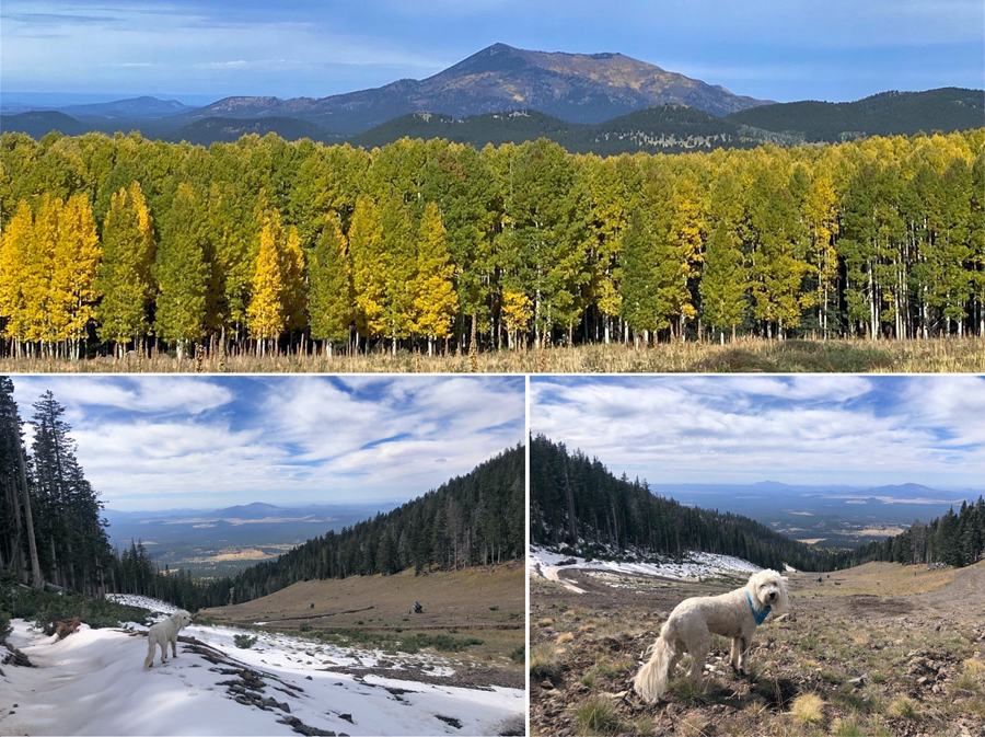
- Views along the ridge and summit were phenomenal and the Aspen trees near peak foliage made the sites even prettier.
- Temps were in the mid to high 40's with sunny skies to begin the day with some high clouds rolling in as we made our way back down.  We trail ran the descent back to the trailhead, with me "Supermaning" on a flat dirt section just a few hundred yards from the Jeep.  Quite the way to end a hike!
- Ten days later we headed back with Whitney.  Temps were a little cooler, in the low 40's, but the wind was whipping making it an invigorating hike at times.
- The hike to treeline was mostly over a slick packed snowy trail which none of us were looking forward to heading back down later in the day.  Once above treeline we battled the wind across the ridge to the summit, luckily there was less snow along the ridge than ten days ago which made rock hopping through the wind easier than anticipated.  The last few hundred feet up the summit cone the wind was howling so once summitting we snapped a few pics and got the heck out of there and made our way back across the ridge to treeline.
- When we reached the switchbacks and the snow covered trails I took us on a shortcut off trail to the ski slopes, this is the same shortcut Whitney and I did in 2017 to avoid the long slog back out over the slick trails.
- The bushwhack was open and easy and we made it to the ski slopes in about ten minutes where we enjoyed a much easier and faster hike back to the Jeep.

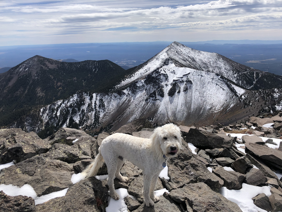
Sarge above treeline on the Humphreys Trail

Looking down into the Inner Basin

Todd and Sarge taking in the 360 degree views

Aspens closing in on peak foliage down at lower elevations in the Inner Basin

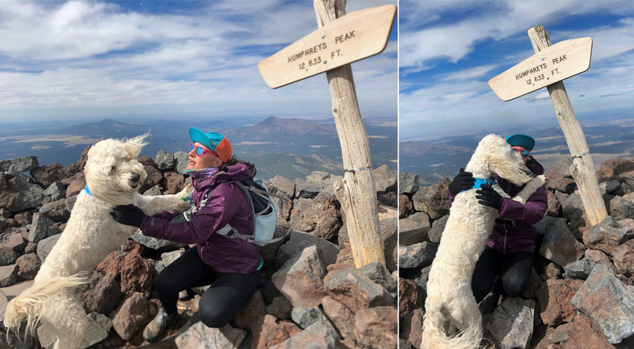
Summit photo with the pup

Sarge greats mommy with a kiss at the summit

Agassiz Peak in snow and Freemont Peak with almost no snow behind Sarge

Jumping on the ski trails and looking northwest towards Kendrick Peak

Enter the Vortex . . . Sedona

Wilson Mountain 10/13/21
Wilson Mountain Trail: 9.1 miles (2,664' elevation gained)

Boynton Canyon 10/18/21
Boynton Canyon Trail / Herd Path / Boynton Vista Trail: 9.3 miles (1,490' elevation gained)

Trip Report:
- On Wednesday the 13th we got up early and headed south to Sedona for a hike of Wilson Mountain, The drive to Sedona through Oak Creek Canyon on 89A is picturesque and we made it to the small trailhead at Midgley Bridge just after 7AM and were on trail for 7:15AM. 
- Wilson Mountain Trail is very gradual with decent footing as it meanders above a ravine to a wide open plateau to the junction where the North Wilson Trail joins in for the final push to the summit.  The plateau is an exposed section of trail, which was perfect for this day as it was a chilly start so the sun warmed us up pretty quickly.
- Sarge was along for this hike and he was leashed up for the ascent making sure not to let him step off trail as there were cacti and other sharp edge desert plants immediately off the trail.
- There are two viewpoints on Wilson Mountain, the south and north. We headed to the south one, the Sedona Overlook, as it has superior views and is a much quicker hike.  The north outlook has a good view too but most of it is obstructed or it was in 2017 when I was there and IMO is not worth the hassle.
- We made decent time up to the summit of Wilson Mountain, the highest point in Sedona at 7,122 feet, and relaxed and took of the expansive views before jogging back down. On the descent I let Sarge off leash commanding him to stay behind me with Whitney and Todd in tow. He was a good dog an behaved for the whole run down.
- We made it back to the now full trailhead just after 10AM, it was still early so we drove to do an easy short hike to Submarine Rock. Good views are to be had at Submarine Rock and it's a perfect spot to watch the Sedona Pink Jeep tours drive off road which was a pretty cool site to see considering I classify my Jeep as a "Mall Jeep" as it hardly does any off roading, is an automatic, and I wash it and clean the inside once a week May through October! 

Early morning on the Wilson Mountain Trail

Looking up to the summit plateau of Wilson Mountain

Sedona, beautiful views in all directions

Out in the sun looking back at where we came up from

Heading to the summit, some lingering snow from Tuesday's storm

Wilson Mountain's Sedona Overlook

All smiles on the summit for Sarge and Whitney

Todd gets a great long range photo of Humphrey's Peak

Myself, Sarge, and Whitney trail running back down

Heading to Submarine Rock

Sarge on Submarine Rock

Pano from Submarine Rock

Sarge enjoying the views

Sarge with mommy!

Pink Jeep tours!

Boynton Canyon 10/18/21
Boynton Canyon Trail / Herd Path / Boynton Vista Trail: 9.3 miles (1,490' elevation gained)

Trip Report:
- On Monday the 18th we headed back to Sedona early to beat the crowds that flock Boynton Canyon's vista outlook where a vortex is located. Our hike would be to the actually canyon itself, an off trail trek to the Subway Cave, and then to the vista for the vortex.
- The Boynton Canyon Vortex is said to have a "balance of masculine and feminine energy," whatever the hell that means, all I know is that it's good people watching.
- The trail to all three spots is very easy, we started off with the Subway as that area is pretty small and is best experienced with no crowds, luckily there were only two others in the subway when we got there.  The Subway Cave is a cliff with high rounded walls that resemble a subway tunnel. Close by are old cliff dwellings and petroglyphs from the Sinagua people "Without Water" from as far back as 1,500 years ago I believe.
- After exploring the Subway we backtracked to the trail and hiked to its endpoint where there is a nice view as canyon walls rise high above. We took a snack break here before heading almost all the way back to the trailhead before branching off on the short side trail to the vista where the vortex is located.
- We ran into a local eccentric, Robert Sechrengost, on our way to the vista. He is known as the Flute Man, Heart Shape Rock Guy, Unconditional Lover, etc.  He introduced himself and gave a speech about love and handed us each a heart shaped rock.  Click here for an article about him and here for a video of him playing flute in the vortex.
- We finally made it to the vista where there are two towering rock formations, one is referred to as Kachina Woman and the other is Warrior Man. The vista is a pretty spot but I didn't feel any energy flowing through me but I'm pretty sure Sarge did as he had a vacant look on his face, more so than usual. We let Sarge meditate for a few minutes before heading back to the Jeep and driving into town for a pretty stellar lunch with one of Whitney's AZT thru hiker friends at the Sedona Beer Company.

Heading into the Subway Cave

Photoshop magic, Todd gets two pics of us on each side of the Subway

Heading to the cliff dwellings

Walking along the cliffs

Sarge and I in the Subway

The high walls of Boynton Canyon, cliff dwelling, and petroglyphs

Sarge taking in the views at the end of the Boynton Canyon Trail

Boynton Canyon Vortex. Todd in front of Warrior Man while Whitney and Sarge stand in front of Kachina Woman