
Date of Hike: 3/6/17


Tote Road: 3.25 miles / Marston Trail: 5.0 miles / Fort Bushwhack: 1.75 miles : Marston Trail: 0.8 miles / Mount Coe Trail w/South Brother Spur: 4.3 miles / Marston Trail: 3.5 miles / Tote Road: 3.25 miles
Total Miles: 21.75 (5,093 feet elevation gained) Garmin Forerunner 920XT
Trip Report:
- Going into this winter, Whitney, Tim, and I had a goal to finish the Winter New England 67 Four Thousand Footers. We knew we'd be able to get to 66, but the wild card would be the last peak, North Brother, as it is the most remote and hardest peak to hike in the dead of winter. It's not because of the exposure, the Presidential Range and Katahdin have it beat in that department ten fold, but because of the trail, more specifically the low trail corridor during winter becomes an obscure, buried, tangle mess of branches and fresh blowdowns above 3,000 feet. It's a knife fight in a ring with a bull, but the one in which you're the bull in the ring surrounded by knives, you just have to thrash your way through to the end!
- On Saturday, Whitney and I drove up to Millinocket to meet Matt and Tim at Ruthies for dinner and a good night of rest before Sunday's long drive down the bumpy Golden Road, Telos Road, and Williams Pond Road to our starting point. Usually in the winter there is a six mile sled pull in from Telos / Williams Pond Road junction, but as luck would have it logging activity had the road plowed two and a half miles in so we had a very easy three and a half mile sled pull into Nesowadnehunk cabin.
- The cabin is brand new and sleeps eight, it has a nice wood stove which heats up the cabin quickly and is easy to use. The old cabin, Camp Cozy, is still standing but no longer in use for hikers as far as I know, it just has one room and is kind of dingy.
- As the day winded down we expected four other hikers to arrive but they never did, come to find out they had no idea where to start their sled pull off Williams Pond Road to Nesowadnehunk, and they just roamed around numerous logging roads all day before calling it quits, brutal!
- Around 7PM we heard a knock on the door, it was two hikers who were doing an out and back from Williams Pond Road in a day of the Brothers, Fort, and Coe. They both told us what we should expect tomorrow and where the nasty stuff would be, basically what we thought, above three thousand feet to North Brother, but they did say the whack to Fort was easier than the summer so we were pleasantly surprised.
Monday morning we started at dawn down the Tote Road to Slide Dam, it was a balmy negative ten degrees out but there was no wind, and the temperatures would be rising quickly into the high twenties so staying warm would be a non-issue by the time we gained the ridge.
- After a brisk three mile walk we cut into the woods and intersected the Marston Trail and angled our way up towards Teardrop Pond, so far so good, as conditions were hard packed boilerplate snow, perfect for microspikes.
- Just above the pond the trail starts to gain elevation and the grade steepens, soon after the steep section the real fun began! The Marston Trail is not well maintained so the tree branches in the winter become head high, chest high, thigh high, and soon enough, body length high. Your're basically pushing through branches trying not to get stabbed. This goes on and off for the next mile until the Mount Coe trail junction, which was buried under the snow! Honestly, I loved this, it reminded me of when I was a child crawling over and under trees through the snow in the woods behind my house with friends.
- From the trail junction we had eight tenths of a mile to the summit of North Brother, it's a flat section followed by a steep burst uphill to the summit, the flat section had the gnarliest crap I've ever had to push through on a trail. Fortunately, the steep burst up to the summit wasn't too bad, we were all very happy to pop above the trees after the previous mile and a half of fighting through the trail.
- We put on our Crampons for the hike up to the summit cone of North Brother. It was a crystal clear day with no wind, it was very warm by winter standards and it was exciting to stand on our final winter peak.
- With the weather being so perfect we headed over to Fort. We have all hiked this in the summer, it's a thick and fun whack, relatively easy to follow too, just slow going. With the conditions the way they were on Monday we were able to basically cruise over to Fort and back easily, spending most of the time baking in the sun as we hiked.
- From North Brother we headed back through the thick stuff to the Mount Coe trail junction, we knew what was in store for us heading back there, plus Tim managed to cut a few blowdowns on the way to North Brother, so the hike back was not as taxing.
- With the weather being so perfect we kept on trucking, next up was South Brother, the trail conditions to the summit to South Brother were very easy, a few low hanging branches but for the most part the trail corridor was open. Views from the summit of South Brother were phenomenal, Mount Katahdin in all it's glory rose high above the Klondike just a few miles across the way.
- Unfortunately, this is where our luck ran out as the trail conditions over to Coe were nasty, first we had a steep side hill with boiler plate snow to descend at an odd angle, the crampons came back out and stayed on. After carefully navigating the side hill we then hooked back onto the ridge proper for our attack on the summit, where we became under attack with more nasty tree branches. After hours of battle through trees, Whitney and Matt had just about had enough, meanwhile I secretly was loving it and I think Tim was too!
- Finally, we summited Mount Coe, what an awesome feeling it was and what awesome views there were. Hoping to only summit North Brother, adding on Fort, South Brother, and Coe was a major steal!
- After taking in the views for a few minutes we had to reorganize and had back the way we came, first the thick stuff, then the 40 degree boiler plate snow, then the tree tunnel off the ridge back to Teardrop Pond. Now was not the time for any mishaps, but the good news is our group is smart and careful so we made our way across the ridge and then off of it unscathed, not counting the numerous stabbings by the trees to different parts of our bodies of course!
- On the way out we caught the sun fading away behind the Doubletops and finally turned our headlamps on about two miles above the Tote Road. Once on the road we quickly covered the three miles back to the cabin where the party of four who were lost the day before on numerous logging roads welcomed us back to a nice warm cabin. After changing into warm and dry clothes we made dinner and celebrated with a couple of drinks.
- After finishing the New Hampshire 48 - 4,000 footers in the winter six years ago I never thought I'd complete the remaining nineteen to finish the New England Winter 67 4,000 footers. It was a great journey hiking the Maine peaks in the winter over the past three years with great company. Thanks to Whitney, Tim, Matt, Kyle, and Pam for being a part of a few / all of those hikes, much appreciated!
- What's next on the to-do list for me...I'm hoping to head to the Adirondacks and cherry pick my way through the 46'ers over the next few winters on nice weather days.
- Winter is quickly coming to an end, hope everyone had a great one. :)

- Winter is quickly coming to an end, hope everyone had a great one. :)
Map of our route!
We made it two and a half miles in along Williams Pond Road before having to pull over and start our hike.
Preparing the sleds and heading off along Williams Pond Road
It was a beautiful bluebird day and we had favorable conditions
After three and a half miles we pass over Nesowadnehunk Stream
The ranger cabin is unoccupied for winter
Passing by Camp Cozy, very tiny and very old
Our cabin for the next two nights, a brand new one!
Nesowadnehunk Cabin
Inside the cabin
The bunks and a pano shot of the common area
Monday morning we head out at dawn, taking a right at the almost buried stop sign!
After three miles we see a frozen washout and cut up into the woods saving a few tenths of a mile
Hiking up the Marston Trail. This Birch glade section was very nice
After a few miles the trail becomes more of a bushwhack. Here, Whitney pushes on through a semi thick section. Believe it or not this was a relatively easy spot!
Every one in awhile on our way to the North / South Brother col we were teased with open woods.
Tim digs out the trail junction sign!
Next we head off to North Brother.
Approaching the summit of North Brother
Winter 67 completion!
Pano of Mount Katahdin
Next up, Fort!
Looking over to South Brother and Coe
Descending the summit cone of North Brother
After a few tenths of a mile we head back into the woods for and easy bushwhack
Looking up at Fort Mountain
Looking back at North Brother
Making our way up to the summit
The Travelers
Mount Katahdin
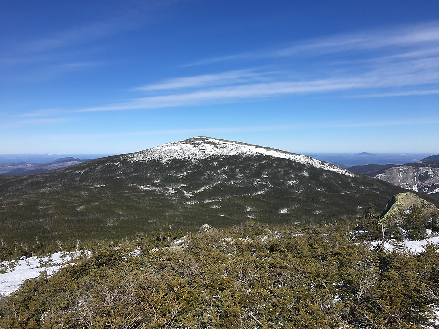
North Brother
The slides of the Doubletops
Heading back to North Brother
Whitney makes her way up to South Brother
Katahdin as seen from South Brother
North Brother
Pano of Katahdin
Close up of Baxter Peak and the Tablelands
Descending South Brother
Carefully making our way down and up boilerplate snow
The Klondike and Katahdin
Mount Katahdin
South and North Brother as seen from Mount Coe
carefully descending the summit of Mount Coe
Descending through the fading sun of the woods
Sun setting behind the Doubletops
Teardrop Pond
A great sunset after a challenging day!
Tuesday's sunrise from Nesowadnehunk Stream
Another shot of the sunrise
Signs spotted on our sled pull into Nesowadnehunk bunk
Signs spotted along the hike
Wonderful write up of our trip honey ��. Your pictures really captured the day well. Thanks for always going on these crazy adventures with me. Love you so much,
ReplyDeleteWhitney
I couldn't ask for a better supportive hiker to be by my side for all these fun adventures :)
DeleteLove you too!
Great write-up, and as always, fabulous photos! Maybe next time I go in the winter I'll finally get to Baxter Peak, and then spend a few more days afterwards to go to the Brothers in the winter. Really nice Nesowadnehunk Cabin!!! Have to laugh though because BSP calls the park a wilderness area!
ReplyDeleteBob N.
Thanks, Bob! Hope you get to summit Baxter next time you head there in the winter. Such a magical place :)
DeleteCongrats on Winter New England 67 4000 footers finish, and great report + pictures as always.
ReplyDeleteThanks, Matt! Glad you enjoyed the pics and report :)
DeleteYou have to come to New Zealand now....:-). I'll drag you up & down some gnarly peaks so that you can take some great photos. These are billiant. Great report.
ReplyDeleteHahaha! It's on our 'someday' list Weta! We will get there!
Delete~Tip Toe :)
Love your write-ups and photos! Haven't seen anything for a few weeks - hope all is well and you're out on more adventures!
ReplyDelete-Stephen
Note used to this long of a break between posts, hope you are healthy and well! Daverip26
ReplyDeleteHi Dave! I'm doing fine, thanks for asking...I'm in Arizona for the month and will have some updates shortly, I've been procrastinating! Hopefully, I'll have a bunch of fun hikes to write up on this summer in the Whites when I get back home too :)
Delete