
Date of Hike: 10/10/15
Signal Ridge Trail: 10.3 miles (3,840 feet elevation gained)
Trip Report:
- Saturday morning Whitney and I planned for a quick hike in Evans Notch before she had to head into work that afternoon. When we woke up Whitney noticed that the Mount Washington Observatory posted a weather update of snow falling during the overnight hours so we decided to change our plans. We first tossed around the idea of heading up the rock pile to play in the coating of snow, but after seeing average wind speeds of 50 plus and temps struggling into the twenties we decided to head to Mount Carrigain to hopefully catch the clouds blowing off the higher peaks to see some snow capped mountains and foliage.
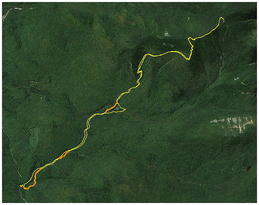
- We arrived at the Signal Ridge parking lot at 8 a.m., jumped on the trail, and hiked at a quick pace over the first two miles of relatively flat trail with great footing. At the old Carrigain Notch split we stayed on the trail and kept to the new reroute. In case anyone is wondering the new reroute makes the hike a half mile longer overall and has a PUD.
- After the reroute the trail starts gaining elevation and it gains it quickly as it steeply makes it's way to Signal Ridge. Luckily the steepness tails off a little after a sharp right turn but the trail seems to go one forever before actually making it up to the ridge itself.
- Around 3,000 feet we saw our first signs of snow, by 4,000 feet there was a nice dusting making the woods look oh so pretty! We kept running into hikers on the way up to Mount Carrigain, one of which was Ken and his very excited puppy, both Whitney and the dog were very excited to see the snow and Ken's dog (Miko I think) happily jumped for joy around Whitney!
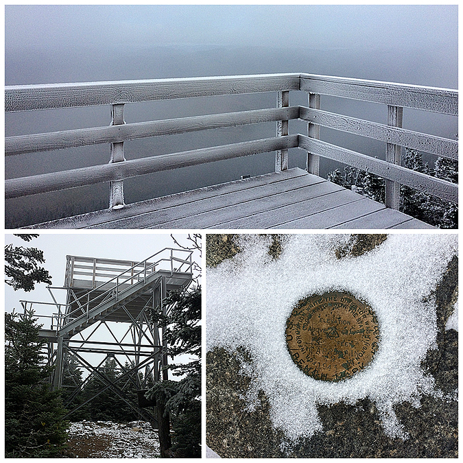
- When we reached Signal Ridge we unfortunately were stuck in the clouds, however we could tell they would be clearing off in probably a half hour to an hour. From Signal Ridge we dropped back into the woods and made the final ascent around and up to the summit tower which had a coating of snow and rime ice. The summit was in the clouds too but started to clear off as we were up there, it was pretty windy on top of the tower so we'd go up, snap a few pics, go down to warm up then repeat the process. After a while we were both getting pretty chilled so we decided to head back down before the clouds completely cleared off.
- From the summit tower back to Signal Ridge we started running into all the hikers we saw on the way up. The views from Signal Ridge were actually a lot better than from the tower, the ridge was now in the clear while the tower was still in a cloud, however it was only a matter of time before the summit would clear off for good.
- Once passing Signal Ridge we dropped back into the woods and warmed up as we dropped a few thousand feet in elevation. We stuck to the old trails on the way out, one by the beaver pond and another that passes over Whiteface Brook and out to the road.
- We were shocked at how many people we saw on the trail as we hiked out, the final count was 78 hikers and four dogs, plus another four hikers and two dogs in the parking lot.
- Back at the car we loaded up the gear and were happy with out decision to change hiking plans. The foliage and snow capped trees looked absolutely perfect!


Signal Ridge Trail: 10.3 miles (3,840 feet elevation gained)
Trip Report:
- Saturday morning Whitney and I planned for a quick hike in Evans Notch before she had to head into work that afternoon. When we woke up Whitney noticed that the Mount Washington Observatory posted a weather update of snow falling during the overnight hours so we decided to change our plans. We first tossed around the idea of heading up the rock pile to play in the coating of snow, but after seeing average wind speeds of 50 plus and temps struggling into the twenties we decided to head to Mount Carrigain to hopefully catch the clouds blowing off the higher peaks to see some snow capped mountains and foliage.
- We arrived at the Signal Ridge parking lot at 8 a.m., jumped on the trail, and hiked at a quick pace over the first two miles of relatively flat trail with great footing. At the old Carrigain Notch split we stayed on the trail and kept to the new reroute. In case anyone is wondering the new reroute makes the hike a half mile longer overall and has a PUD.
- After the reroute the trail starts gaining elevation and it gains it quickly as it steeply makes it's way to Signal Ridge. Luckily the steepness tails off a little after a sharp right turn but the trail seems to go one forever before actually making it up to the ridge itself.
- Around 3,000 feet we saw our first signs of snow, by 4,000 feet there was a nice dusting making the woods look oh so pretty! We kept running into hikers on the way up to Mount Carrigain, one of which was Ken and his very excited puppy, both Whitney and the dog were very excited to see the snow and Ken's dog (Miko I think) happily jumped for joy around Whitney!
- When we reached Signal Ridge we unfortunately were stuck in the clouds, however we could tell they would be clearing off in probably a half hour to an hour. From Signal Ridge we dropped back into the woods and made the final ascent around and up to the summit tower which had a coating of snow and rime ice. The summit was in the clouds too but started to clear off as we were up there, it was pretty windy on top of the tower so we'd go up, snap a few pics, go down to warm up then repeat the process. After a while we were both getting pretty chilled so we decided to head back down before the clouds completely cleared off.
- From the summit tower back to Signal Ridge we started running into all the hikers we saw on the way up. The views from Signal Ridge were actually a lot better than from the tower, the ridge was now in the clear while the tower was still in a cloud, however it was only a matter of time before the summit would clear off for good.
- Once passing Signal Ridge we dropped back into the woods and warmed up as we dropped a few thousand feet in elevation. We stuck to the old trails on the way out, one by the beaver pond and another that passes over Whiteface Brook and out to the road.
- We were shocked at how many people we saw on the trail as we hiked out, the final count was 78 hikers and four dogs, plus another four hikers and two dogs in the parking lot.
- Back at the car we loaded up the gear and were happy with out decision to change hiking plans. The foliage and snow capped trees looked absolutely perfect!
On the way to the trailhead we catch a rainbow as we head through Bartlett...a good omen!
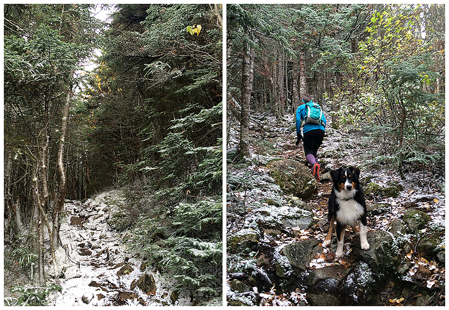
The lower section of the Signal Ridge Trail is a lovely walk through the woods, there are many colorful leaves down put still tons of green in the woods
Snow line was at 3,000 feet
Ken's happy dog (Miko, I think) loving the freshly coated trail
We break out of the woods and onto Signal Ridge, the sun is slowly overtaking the sky as the clouds blow off
Looking down at Vose Spur and the scarred walls of Mount Lowell
Whitney makes here way along Signal Ridge (AKA Burnt Hat Ridge) as the clouds briefly clear off the summit
Mount Carrigain's summit
Snow and rime ice blankets the pine trees as the clouds clear off revealing the foliage in the Pemigewasset Wilderness
The wind was whipping and the clouds would break then come rushing back in
Looking out towards the Bonds and Guyot. The Bondcliff ridge has a dusting of snow
That Hancocks (top), the Desolation Trail down into the Pemi Wilderness (bottom)
Vose Spur and Mount Lowell
Looking to the east, Mount Chocorua off in the distance
Sawyer River Valley
Descending back down the Signal Ridge Trail. Colors where more prominent on the upper and middle sections of the trail
Beaver pond on the old section of the trail (top), Whitney navigates some minor mud and a slippery bog bridge towards the end of the trail
Over the last few tenths of a mile I hook onto another old section of trail over a wide and tricky water crossing. Great foliage at this spot made the detour worth it!
Route for the day, click here for details. The orange is the old trail, pre Tropical Storm Irene reroutes
The major reroute where the Carrigain Notch Trail junction used to be. Old route is in orange, reroute is in yellow. Old route is 0.25 miles while reroute is 0.50 miles
Excellent pictures, I really like the old route compare to the new. Great info!
ReplyDelete