
Date of Hike: 6/2/12
South Meadow Truck / Van Hovenbrg / Phelps Spur Trails: 9.4 miles (2,000 feet elevation gain)
Trip Report:
-Saturday was a wash with a steady drizzle and low lying clouds. I had no intentions of hiking a mountain so I decided to head over to the Ausable Club and stroll down Lake Road and if the clouds lifted a little I would head over to Indian Head, Fish Hawk Cliffs, and maybe Rainbow Falls. As I parked my car and put on my backpack the drizzle was now heavier so I thought what's the rush, let me wait in the car a little longer to see if the steady drizzle tapers off. I threw my backpack into the back of my Jeep Compass, closed the hatchback and immediately said "Oh Sh!t." My backpack had my keys in it, my car was locked! Luckily enough I was at one of the very few trailheads where civilization was in abundance, the private Ausable Gulf Club, so I went into the main building, called AAA and within an hour of locking my keys in my car a truck came, the guy got out this cool contraption that looked like a canvase like sleeve which he wedged into the door jam, then squeezed a rubber valve which blew air into the sleeve expanding it creating a tiny open space into the car where he then took a long wire and snaked it into the car was able to tap the wire on the unlock button and BAM I was saved!
- After all this hoopla I had no interest of walking Lake Road in the drizzle and oddly enough I was now 0 for 2 at the Golf Club, last year I backed the Xterra into a rock in an embankment, leaving a cool looking dent. So I decided to cut my losses and head north to see if if it was any dryer.
- Luckily as I drove out of Keene Valley the rain stopped and actually it was relatively dry so I pulled onto Adirondack Lodge Road, banged a left onto South Meadow Road, and started hiking on the South Meadow Truck Trail to Marcy Dam.
- The dam is still compromised and the bridge over it will not be replaced (I think), the DEC are in the process of building a bridge downstream from the dam but it's just not the same as the bridge over the dam. I was lucky enough to get to hang my feet off the bridge last year and enjoy the views of Marcy Dam Lake and the mountains before Hurricane Irene swept the bridge away, damaged the dam, and drained the lake.
- I decided to head up the Van Hoevenberg Trail to the Phelps Spur Trail to the summit of Phelps Mountain. I was amazed to see about two dozen hikers on the Van Hoe Trail with the weather being so crappy. Most of these hikers were teenagers trodding through the mud with that "will this ever end" look on their faces!
- The trail up to Phelps starts off ok but then becomes muddy and rooty. It's not a fun trail but not difficult at all and there are pretty good views from the summit ledges, however on this day it was heavy smoke/white colored clouds. So I snapped a few pictures and jetted back down to the Van Hoe Trail and back to Marcy Dam where I took a quick break before trail running the final 2.5 miles back to the car as the rain started to fall.
- It was a no views hike but I was really happy that I was out there on the trails considering I went brain dead and locked myself out of the Compass!
Pictures: Click here for all pictures

South Meadow Truck Trail

High Water Bridge over Phelps Brook along the Van Hovenberg Trail

Damaged Marcy Dam

Marcy Dam
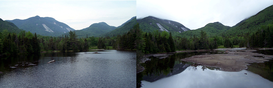
Marcy Dam (before and after)
Chris,
ReplyDeleteGreat report thanks for sharing the adventure!!
Glad you guys all made it thru safely, bet those cold ones tasted good at the end!!
Thanks again for the email,
Graig
Hi Chris,
ReplyDeleteI was one of the two guys you passed close to the summit of Phelps. We were coming down very slowly as you were on the way up. We hiked the Macs the day before and I had messed up my knee pretty good. When you passed by, I asked you where the true summit was. We read your blogs in preparation for our trip and your posts inspired us to give the 46ers a try. I didn't realize it was you until I returned home and read this blog. I have a question for you. How do you hike so fast up and down the peaks. You flew by us. We were in shock that anyone could go down especially at your speed. I am new to this kind of hiking/ climbing. I am use to dusty switchbacks for 20 miles. I understand that you are in shape and I am not, but I am referring more to how do you choose your path. It looked like you walked on top on the rocks rather than in between and around them. The Adirondack rocks seem to have pretty good grip even when wet and mossy. I have always tried to avoid the jagged rocks of the AT in PA because they kill my arches, but I guess the larger rocks of the ADKs won't really do that. Thanks for the blog and great pics too.
Dave.
Hi Dave!
DeleteIt was nice running into you guys up and down Phelps! Glad you like the blog and pics, I appreciate it!
As far as the path I choose and how I'm able to hike fast and not get hurt has to do with a couple of things. One, I've done a ton of hiking over the years in the White Mountains (and now ADK's) and have become accustomed to the awful footing with the rocks, roots, mud, and I realized it's not going up that wrecks you it's the going down. After awhile I just figured out how to 'rock hop', I try to be light on my feet and never drop a ton of force into each step when descending, it saves the knees and the body. Also I try to keep my strides small this seems to help me out a lot. I will say I am very lucky to have been blessed with strong ankles and great balance that helps out tremendously.
Hope this helps!
-Chris