Showing posts with label Tuckerman Ravine Trail. Show all posts

Sarge Hikes to Ho Jo's :)

Date of Hike: 1/3/18 / 1/10/18 / 1/19/18

Tuckerman Ravine Trail: 4.8 miles (1,850 feet elevation gained)

Trip Report
- Our puppy Sarge has been cooped up inside most of the past two weeks because of the bitterly cold temperatures.  Luckily on Wednesday the temperatures shot up to a balmy twenty degrees, so I put the musher's secret wax on and in between his pads and headed to Pinkham Notch.
-  I took Sarge here knowing that the Tuckerman Ravine Trail would be packed out solid and is a easy ramp like hike to Hermit Lake, AKA "Ho Jo's".  This would be his longest adventure yet, but with all his saved up energy it was the perfect spot to get him out.
- He absolutely loved it, running up ahead of me and stopping to wait, saying hi to the skiers hiking up to get in some runs.  Basically, he wagged his way up to the ranger cabin at Hermit Lake.
- After a ten minute break at Hermit Lake, we jogged most of the way back to the lot, stopping a few times to help Sarge get rid of some snow balls that were starting to build up.  The Musher's secret makes it easier to remove the built up snow, it slides right off, and he was back to running and grabbing sticks in no time!
- It was a blast to get him out of the house and tire him out, unfortunately the worst of the weather was yet to come as this weekend has been arctic brutal!  Thankfully the end is in sight as temperatures will be on the rise all week.  Hopefully, there will be no more extended periods like this for the rest of the winter but I'm not counting on it, I have a feeling that it might be a rough one, hope I'm off on that.  Stay warm and safe everyone!

Sarge heads up the Tuckerman Ravine Trail

Sarge waiting for me!

Sarge dreaming about skiing the headwall, or maybe he's just dreaming of cookies!

Sarge at Ho-Jo's!

Avalanche safety Sarge!

Running back down Tucks :) 

Morning on Mount Washington and Mornoe

Date of Hike: 8/30/17

Old Jackson Road: 1.8 miles  /  Nelson Crag Trail: 3.6 miles  /  Gulfside Trail: 0.9 miles  /  Westside Trail: 0.9 miles  /  Davis Path: 0.4 miles  /  Tux X-Over: 0.8 miles  /  Crawford Path: 0.8 miles  /  Mount Monroe Loop: 0.7 miles  /  Crawford Path: 1.6 miles  /  Tuckerman Ravine Trail: 4.3 miles
Total Miles: 15.8 (6,736 feet elevation gained) A.M.C. White Mountain Guide Online

Trip Report
- Wednesday, I had some free time to sneak in a hike before having to be back home for noon.  I woke up early and headed to Pinkham Notch to quick hike Mount Washington and Mount Monroe.  I decided to ascend Washington via Old Jackson Road and Nelson Crag Trail.  Old Jackson Road is an easy hike with easy grades, it's not too exciting but it goes by quick until the real hiking begins on the Nelson Crag Trail.  The trail is rough and steep to treeline, it's a real butt-kicker, but it's worth it as the views are great once above treeline.  The trail is also less traveled, so even in the summer you're not likely to see many hikers.  It does go by the auto road at Cragway Spring, so there will be some commotion there, but overall it's mostly a quiet hike up the Crags.  Since I was on the trail at 6:40AM, there were only a few Auto Road workers on the road when I passed by just before 8AM.
- I reached the summit just before 9AM, I had the summit sign all to myself and took a five minute break sitting underneath it while eating a snack before continuing on.  It's not very often you can lounge around the summit sign undisturbed for as long as you please, so it was a pretty cool moment.
- Next I continued on, taking a less than direct route to Mount Monroe via Gulfside, Westside, Davis Path, Tuckerman Crossover, Crawford Path around Mount Monroe, then Mount Monroe Loop over the summit from the south.  It was a fun and different way of dropping down to Monroe.
- From Monroe's summit I headed down to Lakes of the Clouds and then back up to Mount Washington's summit arriving back on top at 10:42AM.  This time there were hikers and tourists out and about, but it was still relatively quiet, there was one couple taking a picture at the summit sign, so I went back up again and enjoyed a moment alone at the sign after they left.
- Now it was time to head back home, since I wanted to be back for noon, I "ran" down the Tuckerman Ravine Trail.  For the most part, the trail is not runnable until passing by the first aid cache at the floor of the ravine, so pace is determined on rock-hopping, where you have to be very careful to pick and choose boulders, not smaller rocks that move, to "tap dance" down.  From the first aid cache the trail can be trail run at a decent pace, keeping in mind to be courteous to hikers and not running up on or into them.
- Since conditions were favorable, (dry rocks) it was a quick "run" down to PNVC, making it to my jeep in fifty minutes, and then making the ten minute drive back home, arriving a few minutes before noon.  It was the second straight year I was able to hike Mount Washington on the anniversary of my first hike of the rock pile back in 1988, hopefully I can make this an annual occurrence since moving up to the White Mountains in November of 2105.  I am very lucky to have been able to spend an absurd amount of time on this mountain, something I am always grateful for. :)

 The bottom of the Nelson Crag Trail, rough and steep, below treeline White Mountain hiking at its finest

Breaking above treeline on the Nelson Crag Trail

Once above treeline there is a great view across the notch of the Wildcat Range

An Auto Road worker driving up to the summit early in the morning 

 Looking to the south out of Pinkham Notch

Heading up the Crags, Ball and Nelson, with Washington

The final push to the summit of Mount Washington

Nelson Crag Trail terminus at the summit 

Top of the northeast!

Hiking over the tracks along the Gulfside Trail

The Great Gulf Wilderness and the Northern Presidential Range
(Jefferson, Adams, Madison)

 Mount Monroe and the Southern Presidential Range from the Westside Trail

The beautiful layout of the Davis Path

Tux X-Over junction

Looking down at an odd clearing, which is a spot where the original cut of the Crawford Path went through,  I do believe this is where horses were tied to hitching posts.

Mount Monroe 

 Crawford Path southbound below Mount Monroe

Looking at Mount Washington from 'Monroe Bend.' The first train of the day, the old coal cog train's smoke can be seen.

Monroe and Washington as seen from Little Monroe

 Lakes of the Clouds and Mount Washington

Hiking down Tuckerman ravine Trail

Tuckerman Ravine, the bowl

Tuckerman Ravine, the headwall

 Crystal Cascade

Trail signs spotted from Pinkham Notch Camp to Mount Washington's summit

Trail signs spotted from Washington's summit until the end at Pinkham

Return of the "Knee Hammering" Rocks (Mount Washington)


Date of Hike: 5/16/10

Tuckerman Ravine Trail: 2.5 miles
Lion Head Trail: 1.6 miles
Tuckerman Ravine Trail: 1.0 miles
Lawn Cutoff: .4 miles

Davis Path: .6 miles
Boot Spur: .7 miles
Boot Spur Link: .6 miles
Tuckerman Ravine Trail: 3.9
Total Miles: 11.3 miles (elevation gain 5,100 feet)

Trip Report:
- For the past 5 months I have been hiking in full winter gear or with the gear strapped or stuffed in my pack and although I have enjoyed almost every minute of hiking during the winter I have about had it carrying extra weight seeing that it is now the middle of May. I almost decided to go hike the Catskills this weekend but I figured this would probably be the last time I'd have to bring the gear along eventhough I'd probably use it for only 5 tenths of a mile....I was wrong I only needed it for about 2 tenths of a mile! So I sucked it up and with great weather forecast for Sunday I set my sights on checking out the skiers and boarders in Tuckerman Ravine and of course a quick hike up to Mount Washington's summit.
- Left RI at 4:15am, on trail at 8am, summited 11am, finished at 3:30pm. Temps at trailhead to Hermit Lakes Shelter 50-60 degrees, temps on summit 30 degrees, 50-70 MPH winds, wind chill 10-20 degrees...clouds gave way to a clear bright sunny sky with 100 + visibility!
- The route that I had planned to hike was Tuckerman Ravine trail to Lion Head trail (up and down), and head over to the bottom of Tuckerman Ravine and watch the skiers from Lunch Rocks.
- I stopped in at Hermit Lake Shelter to ask the caretaker about trail conditions and just to double check the weather report. After refueling and changing gear I went back to the Lion Head Trail junction and started on my way towards treeline.
- Above treeline winds were constantly whipping out of the west/north west right into my face and I had to break out gloves/hat/winter wind breaker
- Lion Head Trail is mostly snow free now and the knee hammering rocks have returned after months of being hidden beneath the snow. There were a couple of steep sections of spring snow just past the Alpine Garden junction where I used my crampons for about 5 minutes eventhough they were not needed and didn't help much.
- The trail hooks back up with the Tuckerman Ravine trail .4 miles below the summit and the trail becomes a series of boulders which you get to enjoy until just below the summit where the trail ends at the lower parking lot where you are greeted by about 50 of the most annoying wooden steps known to man!
- Wind speeds at the summit were fast and furious making it fun to try and attempt to stand upright on the observation deck
- The inside of the summit building is now open for hikers but nothing else is up and going inside, but it's nice and warm and was a perfect chance to eat lunch and warm up.
- On descent when I arrived at the Tuckerman/Lion Head junction and decided "screw it I'm going over to the Boot Spur and down the boot Spur Link!"
- The hike over the Lawn cutoff, Davis Path, and Boot Spur was very windy but the views and almost no one on the trail made it a great hike.
- The Boot Spur Link on the other hand was not so much fun below treeline where the snow still lingers a few feet deep and the trail is extremely steep. I started off kicking in step after step for .1 mile...to no avail, then I decided to butt slide for .1 mile...way to fast and not safe, so with my A$$ and hands numb I had to put on my snowshoes for about .1 mile until it leveled out where I took off the snowshoes and immediately postholed both legs into the snow up to my waist!
- The Boot Spur Link conveniently comes out right at Hermit Lakes Shelter where I then hiked .7 miles up to Lunch Rocks at the bottom of the Tuckerman Ravine Headwall to relax for a while and watch all the skiers slowly make there way up parts of the ravine then ski back down. There were about three dozen people watching from lunch rocks and about two dozen skiers scattered all over the ravine where there were no crevasses.
- The hike back to Pinkham Notch was pretty fast and very boring as the Tuckerman Ravine trail from Hermit Lakes to PNVC is not difficult but after a long day your knees get beat up on the rocky trail-bed which is not so enjoyable!
- back at the car I went to the pack room to stretch and relax before I headed to stay in Gorham for the night to prepare for Monday's hike of Galehead and the Twin Mountains...all in all another awesome day of hiking above treeline!

Pictures: Click here to view all pictures

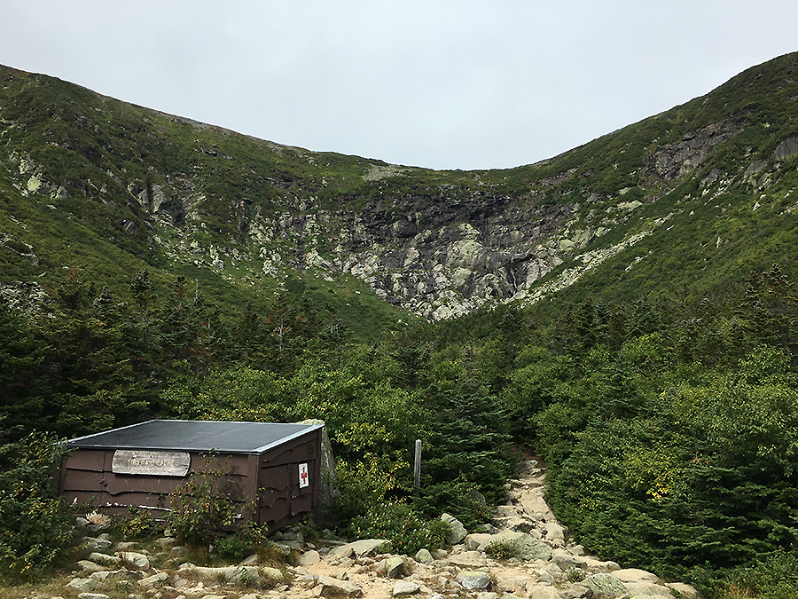
Hermit Lake Shelter
Tuckerman Ravine Headwall
Wildcat and Cater Mountains from Boot Spur Trail
Tuckerman Ravine
Floor of the ravine and 'Lunch Rocks'

Mount Washington and Monroe (Huntington Ravine up, Boot Spur Trail down)

Date of hike: 9/20/09

Tuckerman Ravine Trail: 1.3 miles
Huntington Ravine Trail: 2.4 miles
Nelson Crag Trail: .8 miles
Crawford Path: 1.5 miles
Mount Monroe Loop: .5 miles
Crawford Path: .5 miles
Camel Trail: .7 miles
Davis Path: .7 miles
Boot Spur Trail: 3.4 miles
Tuckerman Ravine Trail: .4 miles
Total Miles: 12.2 (elevation gain 5,100)

Trip Report:
- After taking a beating the previous day in winter conditions I was going to skip out on this hike and do an easier hike (Osceola's). However I decided to check myself into a motel (Moose Brook in Gorham) stuff my face with food, drink a few cheep beers, take a hot shower, and watch hours of college football (Go ND!). The next day I awoke to summer conditions and decided to tackle Huntinington Ravine eventhough my knees were still aching from the hike above treeline and the two annoying falls coming down howker ridge yesterday
- Left motel around 7:30am, drive down Route 16 to Pinkham Notch was great, not a car on the road, not a cloud in the sky and already 50 degrees.
- On trail at 8am, finished at 4:15, temps below treeline and in the ravines mid 60's, temps above ravines high 40's to mid 50's, 30-45 mph wind. Not a cloud in the sky, visibility 125 miles plus
- Before I reached the fan (huge open boulder field below the headwall) I ran into a group of 8 people who for .2 miles would not let me pass them, when they finally did they wouldn't get out of the trail forcing me to tippy-toe my way around them, I was thankful that I didn't have to deal with them or watch them on rock scrambles
- The first rock scramble up the steep and smooth slope of the main gully now has two routes. The original route is to follow the arrows, however about 2/3 the way up if conditions are dry and you trust your balance you can slowly walk across the exposed slopping ledge to the scrub on the other side and bypass the last steep section that goes up and to the right. However the bypass across the sloping ledge has no hand-holds so you can't crawl across making it pretty tough
- There seems to be another option on the second major scramble as well but it's best to follow the arrows
- The 3rd major scramble I thought had another way around so i took it, got 15 feet up the 20 foot scramble and was screwed, had to go back down by crawling, clawing, and cutting myself up. It's easy to pull yourself up with handholds and jamming your foot in a small space between rocks and lifting yourself over but when you have to go down those options are gone and gravity is on your side in the bad way. If you lean forward the weight from your pack makes things unnerving unless you're an experienced rock climber which I am not, so I went into safety mode until I was down to a safe area
- When I was a teenager I had no issues on Huntington, took Teddy the dog up this trail about 3 times with my dad, now that all seems impossible. Hiking solo for me seems to make the tough parts more difficult, if I was with people I think it's be much easier for some odd reason
- On the final scramble I cought up with a group of 3 people, two young guys in their 20's and an older man in his 50's, the older man was bleeding from his mouth and his face was cut up. He was in good spirits and was not hurting, just roughed up when his face didn't agree with an overhanging rock!
- Once above the ravine headwall I ran into a couple coming down the Nelson Crag trail heading to Huntington to go down it, I told them that's not such a good idea, hopefully they took the alpine garden to Lion Head or Tuckerman
- Hiked on tracks again the last .2 miles to summit, arrived at 11:15, left at 12 when the cog arrived with annoying fat tourists!
- Hike on Crawford Path to Lakes was great, could see every mountain in the Whites south of me
- Hike down boot spur had some great views of Wildcat, Carter range, and a close up view into Tuckerman Ravine, I'd imagine with the nice weather there were hundreds of people all over Tuckerman Ravine

Pictures: Click here to view all pictures

Looking up into Huntington Ravine
First rock scramble follow the arrows carefully Jefferson, Adams, Madison from Washington Summit Lakes of the Clouds and Mount Monroe Lakes and Washington from Monroe Loop Cross cairn on Monroe Loop looking south Washington from Boot Spur

Mount Washington

Date of Hike: 10/11/08

Jewell Trail: 2.7 miles
Gulfside Trail: 1.4 miles
Tuckerman Ravine Trail: .4 miles
Lions Head Trail: 1.6 miles
Tuckerman Ravine Trail: 2.3 miles
Total Miles: 8.4

Trip Report:
- Hiked with my dad and Brad Andrews
- Perfect weather, no wind until summit cone, visibility 75 + miles, Temps 40-60 degrees
- Old man hiked tracks last .4 to the summit, took Cog down and picked us up at Pinkham Notch Visitor Center
- Perfect views of Wildcats and Carter Range coming down Lions Head
- Rocks only had frost and very little ice on West side of mountain, and only on last .4 up to summit
- Cloud cover only came when we were at the summit eating and waiting for my dad to finish summiting
- 50+ miles gust on observation deck but little wind anywhere else
- Had the "Usual" at the cafeteria...hot dog, cup of chowder, cookie, apple, and Gatorade

Pictures:
Jewell/Gulfside Trail Junction
Great Gulf Wilderness
Gulfside Trail looking back at Mount Clay
Mount Monroe and Lakes of the Clouds
Lions Head Trail and Wildcat Mountain

Mount Washington

Date of hike: 7/4/07

Tuckerman Ravine Trail: 1.3 miles
Huntington Ravine Trail: 2.3 miles
Nelson Crag Trail: .8 miles
Tuckerman Ravine Trail: 4.2 miles
Total Miles: 8.6

Trip Report:
- Hiked with my college buddy Brandon Blindt and his friend Dan D.
- Hiked at a quick pace 2:45 up, 2:30 down
- Cool above trees, hot in the valley, good visibility
- Cramped up on Nelson crag trail for a few minutes from not drinking enough water, first and last time I've ever got a cramp from hiking

Pictures:

Hiking up into Huntington Ravine, Central and Pinnacle Gully pictured


View from the Observation Tower of the Northern Presidential Range (Jefferson, Adams, and Madison)

On the summit of Washington for the first time in six years!


Observatory Tower


Hiking down Tuckerman Ravine Trail


Looking across the alpine field toward Lion Head