Showing posts with label Mount Moriah. Show all posts

Homeward Bound Loop

Elevation over distance profile (Strava Link)

 
9/20/25

Road Walk & Logging Road: 1.0 miles  /  Stony Brook Trail: 2.8 miles  /  Carter Moriah Trail: 1.2 miles  /  Kenduskeag Trail: 1.4 miles  /  Rattle River Trail: 4.3 miles  /  Road Walk: 0.7 miles  /  Centennial Trail: 3.1 miles  /  Mahoosuc Trail: 3.8 miles  /  Road Walk: 0.5 miles  /  Coos Trail Network: 1.2 miles  /  Pine Mountain Trail: 2.4 miles  /  Ledge Trail: 0.6 miles  /  Pine Mountain Road: 0.8 miles  /  Pine Link : 2.4 miles  /  Watson Path: 0.3 miles  /  Osgood Trail: 0.5 miles  /  Daniel Webster Scout Trail: 3.3 miles  /  Hayes-Copp Ski Trail & Pinkham B Road: 1.5 miles  /  Snowmobile Trail & Bushwhack: 4.5 miles
Total Miles: 36.3 (11,700' elevation gained)

Trip Report:
- On the last full day of summer, I took advantage of the cool and crisp weather to do a loop that started and ended at my home.
- At first light, I walked out my front door, crossed NH16, and bypassed the first mile of the Stony Brook Trail by walking through the neighborhood and an old logging road, intersecting the trail after the first water crossing. 

Early morning walking through the Stony Brook neighborhood. Pine Mountain in view

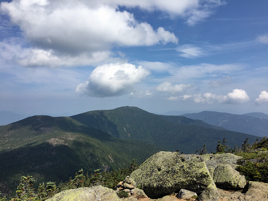
- Stony Brook Trail is not exciting, it has no views, and takes its sweet time to gain the ridge where it comes to the junction with the Carter Moriah Trail. Once on the Carter Moriah Trail, it is 1.2 miles to the summit of Mount Moriah. Along the way, the trail ascends over a couple of open ledges with great views of the Carter Range to the south and the Northern Presidential Range to the west.

Mount Adams and Madison to the left and Pine Mountain, where I will be later in the day, on the right, looking like a small lump!

A.T. blaze cairn with the Presidential Range off in the distance

Mount Moriah summit. Carter Range and Presidential Range in view. Beautiful, crystal-clear day for views!

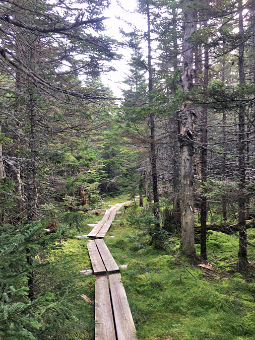
- From the summit of Mount Moriah, I descended Kenduskeag and Rattle River trails, both part of the Appalachian Trail. Kenduskeag has several bog bridges, which made for easy travel over the usual muddy sections that are bone dry because of the summer drought. Rattle River Trail drops steeply for 1.5 miles before a gradual, excellent footed descent over the final 2.5 miles. Along the way, it passes by the Rattle River shelter, which appeared to be empty. 

Well placed bog bridges on the Rattle River Trail

Nice and cushy descent of the lower half of the Rattle River Trail

Rattle River shelter

- Rattle River Trail ends on U.S. Route 2. From the trailhead I had a 0.75 mile road walk on Route 2, North Road, and Hogan Road. It's an easy road walk with a nice view from the hydro dam bridge over the Androscoggin River.

Mount Madison's Osgood Ridge (right), and Mount Washington (left) from the dam

- Part II of the day was to continue along the A.T. up to Mount Hayes before dropping down to Main Street in Gorham. The hike up to the junction with the Mahoosuc Trail is over gradual grades and decent footing. I passed a few Thru-Hikers along the way and wished them luck as they headed into Maine.
- At the junction, I parted ways with the A.T., headed over Mount Hayes, past the ledges, and quickly made my way down the mountain and into town.
- Originally, my plan was to head to Irving to stock up on water and some tasty treats, but they had just started renovations on the building, and the only items available to buy were beer, energy drinks, and scratch tickets. To make sure I had water, I stashed a gallon at the trailhead Friday evening. 
- Before I walked through town, I took a short break, refilled my water bladder, ate some snacks, and organized my pack.

Appalachian Trail marker on the Centennial Trail

Mahoosuc Trail junction at the north peak of Mount Hayes

Soft cushy trails along the summit of Mount Hayes

Town of Gorham as seen from Hayes ledges. Most of my route can be seen in this picture, Moriah to the left, Pine is the little lump on the right, with Madison rising high above it.

Hydro dam on the Androscoggin River located on Hogan Road

ATV/Bike/Pedestrian bridge over Route 16 in Gorham

- Part III; Up and over Pine Mountain. I made my way across the Gorham airfield, hooked onto the Coos Trail network, and intersected the Pine Mountain Trail. Pine Mountain Trail has good footing with easy grades, and I was able to quickly make my way to Chapel Rock, Horton Center, the summit, the ledges, and down to Pine Mountain Road on my way to Pinkham B Road and the Pine Link Trailhead.
- I started to feel a little wonky during the road walk, so when I reached the Pine Link trailhead, I took a short break to stuff my face with a cinnamon bun and chug some Gatorade, instantly feeling better.

Gorham Airfield

Coos Trail Network

Chapel Rock

Horton Center

Pine Mountain Ledges (Madison on the right, Carter/Cats on the left)

- Part IV: The crux of the loop, ascending the steep and rough Pine Link and Watson Path to Mount Madison's summit. I throttled down to conserve my energy as Pine Link Trail until the Howker Ridge Trail junction is a real slog. The two trails coincide for about a half mile and then Pine Link shoots straight for the west side of the summit cone, reaching treeline in short order and the junction with the Watson Path. 
- Once I hit treeline, I had a rush of energy as the breeze and cool temps made the hike much more enjoyable than it had been just moments before when I was in the trees.
- I carefully made my way up the final 0.3 miles to the summit on the Watson Path and reached the summit at 2PM. 
- At the top, I sat down and enjoyed the views of the Great Gulf, Mount Adams, Washington, etc, before a half-mile descent along the Osgood Trail followed by a steep drop down to Dolly Copp Campground via Daniel Webster Scout Trail.
- The DWS trail is rough and rugged for the first 1.5 miles, traversing well below Osgood Ridge at an odd angle on jumbled boulders before dropping below treeline, where mercifully the trail becomes much easier to navigate.
- When I got within 0.3 miles of the end of the trail and the campground, I banged a left onto the Hayes-Copp ski trail to Pinkham B Road for the last part of my Homeward Bound Loop along a snowmobile corridor

Heading up the Pine Link Trail to Mount Madison

Adams and Washington as seen from Mount Madison's summit

Osgood Ridge

Along the Daniel Webster Scout Trail looking back at where I came from. The Pine Link Trail travels up the ridge in the forefront, Pine Mountain below that in the middle right, and Mount Hayes at the top right

- Part V: Snowmobile & Bushwhack solitude. The final four miles were a relatively easy trek along the snowmobile trail that parallels the Peabody River about a quarter to half mile to the west of the river. 
- The snowmo trail has some small rolling hills to deal with, but the path is clear and only gets a little brushy right before I jumped off and started my bushwhack.
- The whack is relatively short-lived, 0.25 mile before steeply dropping down to the river, followed by 0.25 mile of easy river walking back to my home, arriving at 4PM, just under ten hours after I started.
- Starting and ending at my home made for a fun experience, and I'm looking forward to creating another home-to-home loop involving the Wild River Wilderness and the Carter Range next summer.

The snowmobile trail travels through a wide-open field with a unique view of Mount Madison

Junked truck from the 1950's along the snowmobile trail. Soon after this, I jumped off the trail and made my way to the river

Peabody River, a few minutes upstream from my home :) 

Summer Runnin' . . . Presi Traverse & Wild River Loop

Date of Runs: 8/19/18 & 8/25/18

Crawford Path & Webster-Cliff Trail: 4.3 miles  /  Mount Eisenhower Loop: 0.8 miles  /  Crawford Path: 1.2 miles  /  Mount Monroe Loop: 0.7 miles  /  Crawford Path: 1.6 miles  /  Gulfside Trail: 1.1 miles  /  Mount Clay Loop: 1.2 miles   /  Gulfside Trail: 0.8 miles  /  Jefferson Loop Trail: 0.7 miles  /  Gulfside Trail: 1.4 miles  /  Lowe's Path: 0.3 miles  /  Airline: 0.6 miles  /  Gulfside Trail: 0.3 miles  /  Osgood Trail: 1.0 miles  /  Valley Way: 3.8 miles
Total Miles: 20.0 (8,306 feet elevation gained) A.M.C. White Mountain Guide Online

Wild River Road: 0.6 miles  /  Shelburne Trail: 3.1 Miles  /  Kenduskeag Trail: 4.1 miles  /  Carter-Moriah Trail: 8.3 miles  /  Rainbow Trail: 2.5 miles  Wild River Trail: 3 miles  /  Eagle Link: 2.7 miles  /  Meader Ridge Trail: 2.0  /  Basin Rim Trail: 1.4 miles  /  Basin Trail: 2.2 miles
Total Miles: 29.9 (9,144 feet elevation gained) A.M.C. White Mountain Guide Online

Trip Report:
- The past few weeks I have been on a time crunch while Whitney was off hiking the John Muir Trail, I'll have a tab located on the top menu with her write up and pictures in a week or two.  With just Sarge and I at home, I have been taking him for his usual short hikes during the week while mixing in a quick hike up and down of the rock pile (Washington) after work from time to time.  On the weekends I set aside a day for me to push myself and get in miles all within nine hours (door to door).
- On Sunday the 19th I ran a northbound Presidential Range Traverse, starting from Crawford Notch.  I set off at 7AM and quicked hiked to Mount Pierce reaching the summit in 51 minutes.
- I had incredible weather during the morning, cool temps with some good wind gusts.  I was able to run and quick hike as I made my way up in elevation past Eisenhower and Monroe before grinding out the last big climb of the morning up to Washington.  Eisenhower in 1 hour 16 minutes, Monroe in 1 hour 51 minutes, and Washington in 2 hours and 29 minutes.
- For the first half of the run I stopped twice, once to layer up and put my hat and gloves on before Mount Monroe, for those of you not familiar with the jagged summit cone of Monroe it can be very windy and cold.  My only extended break was at Lakes of the Clouds, here I reloaded my water bladder, had a baked good, and some iced tea.  This was probably a seven minute break before heading up to Washington, other than taking pictures and delayering later on, this would be my last stop of the day.
- As I zoomed past Washington it was time to take on the rugged footing of the northern presi's.  The good news is that going northbound through the range is faster (for me) than heading southbound.  The climb up Clay, Jefferson, and Adams are all much easier in this direction, while Madison is the same if using Valley Way followed by and out and back of Osgood Trail.
- As I headed past Clay, 2 hours 50 minutes and then to Jefferson 3 hours 17 minutes, it became clear that not only was I going to break the sub 6 hour goal I set for myself but I could actually challenge my personal best of 5 hours 24 minutes that I had for last year's north to south traverse, something I did not think was achievable since I thought that going north to south was faster.
- I kept on making really good time and beat feat up to Adams making it there in 3 hours 54 minutes.
- Next, I zoomed down to the hut and aggressively hiked to Mount Madison, standing on the summit 4 hours and 20 minutes after I started.
- After taking a few pics it was time to rock hop run off the summit cone of Madison and into the woods for the quick descent to Appalachia.  Descending is still my specialty so I was able to run aggressively, yet carefully, to the bottom in 46 minutes, finishing in 5 hours and 6 minutes after I started.
- I was very happy to have run the Presi's this quickly and even happier for the short drive home to see Sarge and spend the afternoon relaxing in the river with him.
- Unfortunately I deleted my pics, but I did upload them to Strava before they were deleted and they have captions, not great quality and they are out of order, but there are some nice ones in there.  (Click here for Strava details).

Saturday, the 25th I drove to the Wild River Campground and parked my car at the Basin trailhead to circumvent the Wild River Wilderness.  First was a short and easy road run to the Shelburne trailhead, from here I walked to the river bank which has been mostly destroyed.  I dropped down to a few rocks where I removed my shoes and socks and waded about fifty feet from shin to quad deep to the rocky and sandy shore on the other side where I put my socks and shoes back on.  I then quickly lost the trail from all the damage and ended up on the Highwater Trail, thankfully I knew where I was and then took what is left of the Highwater Trail to the junction of the Shelburne Trail, quite the excitement early on!
- Once past the washouts I motored up the secluded and beautiful Shelburne Trail.  The were a few blowdowns but overall the trail is in excellent shape.  The trail makes an easy to moderate climb up to the Howe / Shelburn Moriah col.
- Now came for one of the many highlights of the day, summiting Shelburn Moriah, it has tremendous views of the Wild River Valley, Moriah-Cater Range, and the Mahoosucs.  The views were very muted on this morning as it was getting humid and very hazy but still a great place to take in a quick view.
- From Shelburne I dropped in elevation to the Moriah Col before the steep burst up to the summit.  Moriah and its southern ledges along the A.T. have very nice views as well, from here I can see the small neighborhood I live in and almost my house!
- As I made my way through to the Carter Range the heat and humidity was getting worse.  I was still making good time but I had to throttle down to conserve my water since there was nothing good to filter from until dropping down to the wild River.
- The climb up to North Carter is a steep and nasty one so that slowed me down.  Once I summited North Carter I made decent time through Middle and South before slowing down again on the steep burst up to Mount Hight.  I was very happy to be on top of Hight as from here on out the run is pretty easy.
- Even with all the difficult sections behind me I still paced myself up to carter Dome and then the descent down the Rainbow Trail to wild River Valley.  From Carter Dome until finishing I would see only five more hikers, how cool is that on a Saturday!
- The Rainbow Trail, Wild River Trail, and Eagle Link all have summer overgrowth encroaching the trail but everything was still easy to follow.  It was great to have all the trails to myself and the Birch glades along Rainbow and Eagle Link are always a pleasure to pass through.
- I finally was able to filter water and electrolyte drink when reaching a good flowing source along the Wild River.  This rejuvenated me and I made great time up to Meader Ridge, along the ridge, and down to the Rim Junction.  From the Rim junction I turned up the speed and finished in just under 7 hours and 30 minutes.
- Some takeaways of the Wild River Loop; It would be an easier run in the fall when the overgrowth dies out, cooler temps, and when it's drier.  I'm pretty sure I could run a sub seven hour loop in better conditions and with more water for the Carter-Moriah section but I'm still happy with my time.
- After finishing, I quickly drove home to see Sarge and we immediately headed down to the river where I cooled of and relaxed while Sarge fetched sticks while swimming. :)

Elevation over distance profile

 Map of the route!

Sloppy section of the Kenduskeag Trail north of Shelburne Moriah's summit

The sun shinning through the clouds and hazy sky

Mahoosuc Range as seen from Shelburne Moriah

Some very well place bog bridges along the Kenduskeag Trail

The final steep burst up the Kenduskeag Trail towards Mount Moriah

Descending the open ledges of the carter-Moriah Trail just south of Mount Moriah

Just below North Carter's summit and just above the difficult steep rock section

Beautiful view from Mount Hight, looking back at the Carters and Moriah way off in the distnace

from a knob just east of Carter Dome's summit looking back at Carter Dome

The Birch glades of the Rainbow Trail

Traveling through the glades, it's even more beautiful in the fall!

 The Wild River Trail is a little overgrown in spots!

Perkins Notch tentsite, old spot of the lean-to

Some recently added bog bridges (within the past two years) along the Wild River Trail

Eagle Link Trail, just a little overgrown in spots, but still easy to follow

Gaining the Meader Ridge

 Eagle Crag

Basin Pond from just south of the Rim Junction

Signs spotted along the way!

Sarge on Goose Eye during one of our hiking days

Sarge loves the swimming holes :)