Showing posts with label Mount Lincoln. Show all posts

MMD 2024 Franconia Notch

8/11/24

Old Bridle Path & Greenleaf Trail: 4.0 miles / Franconia Ridge Trail: 3.5 miles / Liberty Spring Trail: 2.3 miles / Flume Slide Trail: 3.3 miles / Franconia Ridge Trail: 3.3 miles / Falling Waters Trail: 3.2 miles / Lonesome Lake Trail: 1.4 miles / Fishin’ Jimmy Trail: 2.0 miles / Kinsman Ridge Trail: 4.6 miles / Hi Cannon Trail & Lonesome Lake Trail: 2.4 miles
Total: 30.0 miles (12,500' elevation gained)

MMD Recap:
- 2024 MMD headed to Franconia Notch. This year's route originally was 34 miles a midnight start on Friday/Saturday, but the remnants of Hurricane Debby came through Friday evening until dawn on Saturday turning the trails into a mess and raising river crossings considerably. MMD stands for more and more difficult not more and more dangerous, so I decided to postpone the start until Sunday at 5:30AM and everyone was rewarded with a beautiful day in the notch.
- The day started off with a steady climb past Greenleaf Hut and above treeline to Mount Lafayette's summit. From Lafayette, everyone boogied at differing paces across Franconia Ridge past Mount Lincoln and Little Haystack before dropping back below treeline. Meanwhile, Sarge and I headed up Falling Waters Trail and across Franconia Ridge in the opposite direction to get a few pictures as the runners passed us by.
- Once back below treeline everyone made their way to the Liberty Spring Trail junction and descended a few thousand feet to the Flume Slide Trail. On Thursday I ran the course solo and just below the Liberty Spring tent site I crossed paths with a guy who asked if there was a store to buy food up ahead, I told him he was way off and the closest place to get food was in town, that was a first!
- I had not been on the Flume Slide Trail since the last MMD in Franconia Notch in 2020 and I had forgotten how forgiving the first two miles was until reaching the foot of the slide. However, the slide is still as gnarly and steep as ever, ascending 1,400' in 0.7 miles to the junction of Franconia Ridge Trail. The slide itself is completed in the woods so unlike most slides in the Whites there are no views and it's a real slog and usually wet. There is now a prevalent eroded herd path for almost the entire length of the slide for those who get in over their heads. My first time hiking the slide in 2009 there was maybe one or two ten-to-twenty-foot go-arounds at the two tough spots when the slide was too wet to safely ascend. Everyone, except for Jason made it through the slide unscathed, he unfortunately had a small fall gashing up his forearm but luckily just ended up with just minor bumps and bruises and was able to continue on.
- After gaining the ridge the runners headed over the summit of Flume and Liberty before making their way back along Franconia Ridge to Little Haystack before descending Falling Waters Trail all the way down to an aid station I had setup at Lafayette Place Campground. When I ran down this trail on Thursday, I passed well over 100 hikers heading up so I warned the runners to be patient when they were descending what is commonly referred to as Falling Peoples Trail.
- The aid station was a big success for the runners. It was at mile twenty and had water, soda, Gatorade, and several types of munchies for everyone to pick at. Fruit, especially watermelon was the top aid station snack. I was shocked that out of everything, Pop-Tarts were not taken as a food restock for the remainder of the route, big upset there. 
- The last ten miles consisted of a short burst up to Lonesome Lake where runners could top off water at the hut before heading up the Fishin' Jimmy Trail up to Kinsman Ridge. Once on the ridge, runners did a quick out and back to North Kinsman's summit then continued across the Cannonballs to Coppermine Col before one last steep blast up to Cannon Mountain's summit. From the Cannon Mountain tower it was all downhill back to the campground via the Hi-Cannon and Lonesome Lake trails.
- At the campground runners were welcomed with hamburgers, hotdogs, chips, cookies, and plenty of other food to stuff their faces with after a grinding day in Franconia Notch.  MMD 2024 was a rough and rugged routes seeing participants finish anywhere from 8 hours 30 minutes to 12 hours 30 minutes.
- the day turned out great with an enthusiastic easy-going group who made organizing this fun gathering incredible easy to pull off!


Group shot, 5:30AM start. All quiet at Lafayette Place with Franconia Ridge rising high above us

After 2.9 miles Old Bridle Path reaches Greenleaf Hut and Greenleaf Trail

It's 1.1 miles from the hut to the summit of Mount Lafayette. Looking back at Greenleaf Hut and Cannon Mountain

Sarge takes in the views from Mount Lafayette

Runners have now formed their own groups of two or four and are spread out over a mile + at this point

Sarge paces Ryan across the ridge

Will, Andy, Chad, and Joe run the ridge with Kinsmans and Cannon across the notch

Sarge taking in the views from Mount Lincoln

Ascending the steep Flume Slide

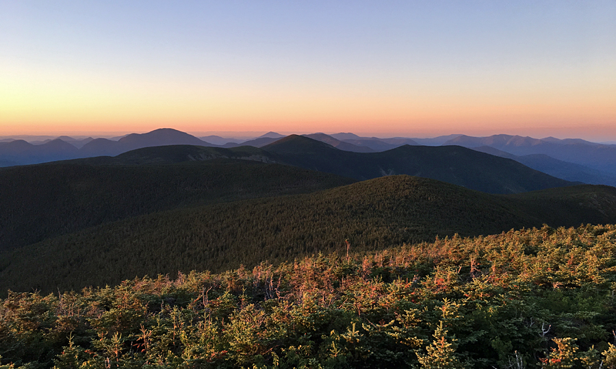
Summit of Flume looking north to Liberty, Lincoln, and Lafayette

Mount Liberty Summit with Cannon Mountain in the background

A well-placed ladder heading back to Little Haystack along Franconia Ridge Trail

Sarge at the alpine zone sign on Falling Waters Trail

Cloudland Falls on Falling Waters Trail

Lonesome Lake

Cara gets a great picture of Joffrey on North Kinsman summit looking across at Franconia Ridge were they spent the morning going up, across, down, up, across, and down!

Franconia Notch from Cannon Mountain summit tower

Lonesome Lake from Hi-Cannon Trail

Post run cookout!

Elevation over distance profile

Hope Springs Eternal . . . Mount Lafayette & Lincoln

Date of Hike: 3/24/21

Old Bridle Path: 2.9 miles  /  Greenleaf Trail: 1.1 miles  /  Franconia Ridge Trail: 1.7 miles  /  Falling Waters Trail: 3.0 miles 
Total Miles: 8.9 (3,900 elevation gain)

Trip Report: 
- With unseasonably warm temps overtaking the White Mountains recently I got an early start on Wednesday to get in a quick hike along Franconia Ridge before work and more importantly to get off the trails before the snow softened up too much to where post holing became an issue.
- Unlike Pinkham Notch which has been absurdly busy this week, Lafayette Place was extremely quiet with only one other car in the lot at 6:30AM
- The trails below treeline still have several feet of snow but were solid enough to make for easy passage with light traction.  Above treeline was a different story, 50/50 bare ground and old rotting snow drifts.
- There was a stiff breeze above 4000 feet but with temps rising to 40 degrees it made the trek across the ridge with a light hat and old ratty gloves easy and straightforward.
- Views were muted from the cloud cover high above blocking out the sun but they were still grand as they always are up here when it's in the clear. I've been lucky enough to have been up here well over fifty times and I never take the views for granted, especially this time since I have been mourning the unexpected passing of my brother recently as he lost his battle with depression.  Wherever he is in the afterlife, I'm sure he is able to watch over me and see the beautiful views I take in while above treeline and hopefully that it eases his pain.  I love and miss you, Joe-Ben :)  

Sarge strikes a pose along Agony Ridge

Sarge heads up Greenleaf Trail with Cannon and the Kinsmans behind him

Summit of Mount Lafayette

Sniffin' and lickin' the wind!

Classic Franconia Ridge Shot

Sarge on the summit of Mount Lincoln

Mount Lafayette behind Sarge

Presidential Range off in the distance

Sarge on Little Haystack with Mount Lincoln in view

Cloudland Falls

Midnight Express . . . Flume to Willey

Date of Hike: 7/21/18

Lincoln Woods Trail: 1.4 miles  /  Osseo Trail: 4.4 miles  /  Franocnia Ridge Trail: 5.0 miles  /  Garfield Ridge Trail: 6.6 miles  /  Frost Trail: 0.8 miles  /  Twinway 0.8 miles  /  North Twin Spur: 2.6 miles  /  Twinway: 2.0 miles  /  Bondcliff Trail: 0.8 miles  /  West Bond Spur: 1.0 miles  / Bondcliff Trail: 3.0 miles  /  Twinway: 4.3 miles  /  Lend-A-Hand Trail: 5.4 miles  /  Twinway: 0.4 miles  /  Zealand Trail: 0.3 miles  /  A-Z Trail: 2.7 miles  /  Mount Tom Spur: 1.2 miles  /  Willey Range Trail: 3.5 miles  /  Ethan Pond Trail: 1.5 miles
Total Miles: 48.85 (17,210 feet elevation gained)  AMC White Mountain Guide Online

Trip Report:
- Friday night at 9:30PM I moseyed my way up to Mount Flume from Lincoln Woods.  I wanted to reach the summit just before midnight before taking off at midnight for a 100K route through the heart of the White Mountains.
- The hike up Flume went well and I was not alone as I would pass by a half dozen other hikers along the way, these would be the last people I would see until dawn!
- I reached Flume's summit around 11:50 and took a break while looking up at the stars shining brightly high above me.  After ten minutes of relaxing and organizing my gear I started my adventure.
- It was rough going during the night heading over Franconia Ridge, I wasn't moving as fast as I had planned and then the Garfield Ridge, my old nemesis, destroyed me during the wee hours of the night, needless to say it became apparent really quickly that I might have to revamp my route and mileage.
- Even with the slower than expected pace I was still having an enjoyable nighttime hike, especially above treeline where the stars and Milky Way looked spectacular.  During one of my breaks on North Lafayette, I saw a shooting star fly across the sky to the northwest.  I also spied a few planes high in the sky, flying east/northeast, maybe they where flying to Europe??!!
-  Some of the other highlights as I made my way across Garfield Ridge were the sounds of dozens of frogs as I made my way past Garfield Pond, stargazing for a few minutes from the summit of Mount Garfield, and carefully making my way down the waterfall section of the trail just below the Garfield Campsite, which luckily was easy since it's been an incredibly dry summer, still it was quite the adrenaline rush dropping down that section of trail.
- The rest of the night hiking went ok, after a few hours I started looking forward to not having to go by headlamp as the final few miles leading up to Galehead Hut and the summit weren't too exciting.  After a short stop at Galehead Hut I was able to ditch my headlamp at 5AM as I started my way up South Twin.
- I reached the summit of South Twin just as the sun was rising up behind the Presidential Range, another really cool sight to see.  South Twin usually has a pretty constant stream of hikers on it's open summit so it was nice to have the top to myself and enjoy the peace and quiet.
- From South Twin I made and out and back of North Twin before heading over to the Bonds.  From here on out I would be seeing more and more hikers, starting along the Twinway near Guyot and every five to ten minutes as I made my way to West Bond, Bond, and Bondcliff before turning around and heading back to the Twinway.
- It was still early in the morning when I dropped below treeline towards Mount Zealand around 9AM.  I had until 5PM to reach Ethan Pond trailhead off 302, earlier I texted Whitney for a car pickup, deviating from my intended route, so I had the whole day to make it there.
- I made good time to Zealand and then down to the hut, where I bought a piece of chocolate cake and relaxed before heading up to Mount Hale via Lend-A-Hand Trail.  This would be one of my last big climbs of the day, luckily the Lend-A-Hand Trail has mostly easy to moderate grades with good footing, there are two short steep rugged bursts over the last mile but that's it for the tough stuff.
- It was an easy out and back from the hut to Hale.  Once again, I took a break and had some food and refueled while preparing my gear for the climb out of Zealand Valley to the Willey Range along the A-Z Trail.  This would be my last big climb of the day, and just like hiking up to Hale most of it was along easy to moderate grades with great footing  before getting steeper and more rugged for the last three quarters of a mile.  The A-Z Trail between Zealand Trail and Willey Range Trail is lightly used so I had this 2.7 miles all to myself.  However, once I gained the ridge it was a totally different story, hikers everywhere!
- I was a bit perplexed as to why so many hikers were out on this viewless range on a perfect above treeline day.  I must have see 50 hikers between Tom-Field-Willey, no wonder why the trail is severely eroded in a few spots, none worse than just below Mount Willey, it's a disaster!  I carefully picked my way down this eroded mess, I was over forty miles in so it was a minor miracle I didn't slip and fall back on my butt at least once, victory!
- Once past the steep eroded part, the trail finally moderates and the footing quickly gets much better as the Willey Range Trail terminates at the junction with the Ethan Pond Trail (A.T.).  From here I slow jogged down to the trailhead where trail magic was going on for thru-hikers.  The smell of food on the grille was too overbearing and made me very hungry, so instead of waiting for Whitney there I headed to down the road to the 302 junction.  Since I finished at 3:15PM, I had a long wait before my ride would come, I spent the time stretching for a good twenty minutes, telling SoBo hikers there's trail magic right up the road, and almost dozing off while I sat on the side of the road.
- Whitney and Sarge came by around 4:45PM and we then retrieved my Jeep at Lincoln Woods before heading back to Gorham where I stuffed my face with food!
- It was a great 17 hour and 45 minute adventure in the heart of the White Mountains, and with some minor tweeking (start at dawn from Flume), I'll come back in the future and complete my intended 100K route 24 hour route. :)

 Map of my route for the night/morning/day

 Elevation over distance profile

View from Frost Trail Outlook, the hut, and heading up the Twinway

Sunrise from South Twin :) 

South Twin Summit at daybreak

Looking towards Guyout and the Bonds

Pemi Wilderness as seen from North Twin.  Shadows quickly retreating as the sun rises

Mount Bond and West Bond as seen from Mount Guyot

Redrock Ravine as seen from West Bond

Bondcliff

West Bond, Owl's Head, and the Franconia Ridge as seen from Mount Bond

Bondcliff Ridge

Bondcliff and Hellgate Ravine

Slides of Hellgate Ravine, close up of the new slide!

Mount Guyot

Hiking along the Twinway

Lend-A-Hand Trail, summer vs. winter!

Hiking near Zealand Pond

Mount Tom Spur

Hiking along the Willey Range Trail

Webster Cliff as seen from Mount Willey

The eroded Willey Range Trail