Date of Hike: 3/1/15
Bike Path & Basin Bushwhack: 0.5 miles / Liberty Springs Trail: 2.4 miles / Franconia Ridge Trail: 2.4 miles / Liberty Springs Trail: 2.4 miles / Bike Path & Basin Bushwhack: 0.5 miles
Total Miles: 8.1 (3,890 feet elevation gained)
Trip Report:
- My original plan was to hike the Kinsmans with Whitney but she didn't get home from work until after eleven on Saturday night so she stayed in. She had hiked Liberty and Flume on Saturday so I decided to head there.
- I started the hike just after 8 a.m. from the Basin parking lot wearing microspikes which I would keep on for the whole hike. Not having to wear snowshoes was a much needed relief on my feet after hiking twenty-five plus miles in them the day before.
- I felt ok along the bike path and heading up the basin bushwhack which ends at the hairpin turn on the Liberty Springs Trail. I even felt pretty good up until the Liberty Brook crossing. However, after the snowbridged water crossing the trail becomes steep and I slammed into a wall of slowness. It wasn't pretty, at one point I managed to pull of a forty-two minute mile, my slowest since a bonking during the Hut to Hut Traverse last July. Eventually I made my way up past the tentsite and up to the Franconia Ridge and I started to feel much better once I hit the summit and took in the views, it's amazing how views can energize a hiker...and knowing a majority of the elevation gain is over.
- From the summit of Liberty I bombed down to the col and made my way to the summit of Flume. There was a small storm coming in but the cloud cover was high so the views were pretty sweet. For a moment I contemplated heading down the Flume Slide Trail but I was a little sore from yesterday and figured just heading back up Liberty and down would be faster even if it's longer mileage wise with some added elevation gain.
- I jogged down to the col and had a strong hike back up to Liberty. From here I basically sprinted back to the Jeep, covering three miles in just over thirty minutes.
- It was my nineteenth ascent of Liberty and Flume since 2009 when I first climbed them. There are very good views from both summits, on Flume you can see the whole spine of the Franconia Ridge stretching north over Liberty, Little Haystack, Lincoln, Truman, and Lafayette.
- When I got back to my car it was almost twenty degrees, which felt like a heat wave, it was nice not freezing my fingers off while packing up my car after a hike. Spring is just around the corner, and the snow should be gone soon, and by soon I mean late May!
Pemi bike path becomes a snowmobile and cross country ski trail in the winter
This is where you leave the bike path and hook onto the Basin bushwhack. Notice the two parallel trees on the left of the road, head in between the two trees, picture right.
The bushwhack is usually broken out in the winter and ends at the hairpin turn
Hiking along Liberty Spring Trail past the Flume Slide Trail junction
Passing the tentsite and continuing through a thick wall of small pines
Reaching the junction with Franconia Ridge, the trail becomes much easier from here
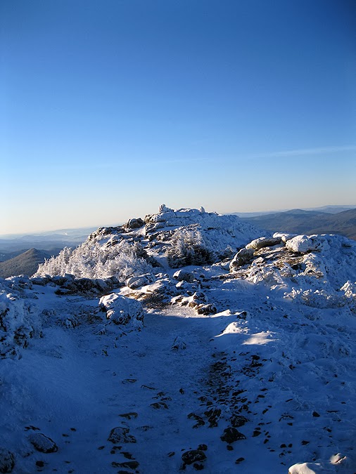
There's only a small Alpine Zone section, around Mount Liberty's summit
The Pemigewasset Wilderness: Owl's Head, the Twins, Guyot, and the Bonds
The slides of the Pemi Wilderness
Mount Lafayette and Garfield above Lincoln Brook Valley
Heading from Liberty to Flume
Flume's jagged summit and a view from Flume's summit north of the Franconia Ridge
Top pic: Mount Moosilauke / Bottom pic: Hellgate Ravine and the Bonds
Mount Liberty with the Kinsmans behind it on top. Lonesome Lake and the Cannon Balls on the bottom
Loon Mount on top. North Hancock and Carrigain on the bottom
Franconia and Garfield Ridge
Heading back down on the Liberty Spring Trail
Back on the bike path back to the Basin parking lot
Route for the day (click here for details)
Splits