Showing posts with label Observation Point. Show all posts

Southwest is Best . . . Hiking Adventures in the Canyons of Arizona and Utah

It's taken me two months but I finally am able to post the report and pics from our hikes in the southwest, Enjoy  :)

In May I made my annual cross country drive to some of the most breathtaking places for hiking in Arizona and Utah.  After hiking solo in the Grand Canyon for two days my girlfriend Whitney flew into Phoenix to join in on the fun.  Below are trip reports with pictures from the hiking adventures we had over the following week.  The weather was unseasonably cool and rainy at times but we got lucky and were able to get in some phenomenal hikes between the storms and wild weather.  Some highlights were hiking to the bottom of the Grand Canyon and back up in a day followed by exploring an old cave and getting pelted with tiny hail the following day.  The wild weather followed us into Utah but we managed to gauge the forecast and hit up a cool little local slot canyon called Peek-A-Boo in Oderville.  Finally, the weather broke and we had three amazing days, first exploring the out of this world hoodoo formations in Bryce Canyon, followed by two days in Zion where on day one we scrambled across the knife edge of Angels Landing and climbed high above the canyon to Observation Point.  This all lead to our final and best hike of our trip, hiking the Narrows, sixteen miles, most of which was walking through a river as canyon walls rose steeply from each side of the river!

Click on the links below to read reports and view pictures

Thursday, May 21st:  Grand Canyon - Rim to River and Back

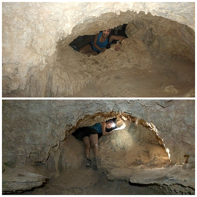
Friday, May 22nd:  Grand Canyon - Cave of Domes

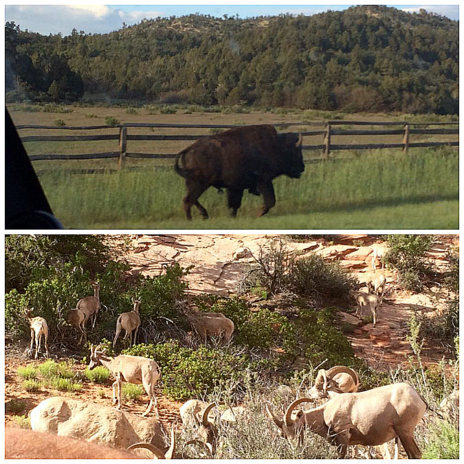
Saturday & Sunday, May 23rd & 24th:  Horseshoe Bend, Rimrock Hoodoos, Peek-A-Boo Slot Canyon, Pink Coral Sand Dunes

Monday, May 25th:  Bryce Canyon

Tuesday, May 26th:  Zion Canyon - Angels Landing & Observation Point

Wednesday, May 27th:  Zion Canyon - Narrows (Top-Down)

Thursday, May 28th:  Lower Antelope Canyon

The Colorado River from the South Kaibab Trail 

 Whitney in the Cave of Domes . . . on her birthday!

 Horseshoe Bend (Whitney's picture)

 Rimrock 'Toadstool' Hoodoos

 Rad Slot Canyon AKA Peek-A-Book Slot Canyon

 The Pink Coral Sand Dunes was kind of lame...so I had some fun! #SMACKERS

 The hoodoos of Bryce Canyon

 Whitney along the knife edge of Angels Landing

 Zion Canyon from Observation Point

The Narrows!

Lower Antelope Canyon

Zion . . . Angels Landing & Observation Point

Date of Hike: 5/26/15

Angels Landing Trail: 4.6 miles (1,620 feet elevation gained)
Observation Point & Hidden Canyon Trail: 8.3 miles (2,590 feet elevation gained)
Total Miles: 12.9 miles (4,210 feet elevation gained)

Trip Report: 
- On Tuesday we again lucked out as the weather finally broke over Zion National Park.  The ride into the park is really wild, you pass through a long tunnel then drive down into the canyon on a steep road with several hairpin switchbacks before bottoming out along the floor of the Canyon.  Once again we got into the park before the rangers had set up at the entrance and got in for free!
- Zion is a little different than the other parks we had visited, between March and October you have to take the free canyon shuttle bus to access the Scenic Drive area inside the canyon walls where the trails to the major hot spots are.  The two most popular spots are Angels Landing and the bottom of the Narrows.  Our agenda for the morning was to beat feet and beat the crowds to Angels Landing.
- As luck would have it we parked the Jeep at the visitor center and hopped right on the shuttle which took us to the Grotto where we jumped off and started the short but steep hike up several switchbacks to Scout Lookout and over to Angels Landing, which is described as follows; The route to Angels Landing involves travel along a steep, narrow ridge with support chains anchored intermittently along the route.  Footing can be slippery even when the rock is dry.  Unevenly surfaced steps are cut into the rock with major cliff dropoffs adjacent.
- It's a pretty exhilarating hike and yes a fall would have gravely consequences, but having been on the Knife Edge on Mount Katahdin (no chains in Maine, man!) this was kind of minor league since every tricky section had chains to help for safe passage.  Within the first fifty feet my anxiety went from heightened to near zero levels as I felt comfortable navigating the narrow passage along the side of the red rock with the huge dropoffs.  The only tricky part was navigating by slower hikers or hikers heading back from Angels Landing.  Once again as luck would have it (timing and luck were the theme of the day) we out hiked most of the tourists up from the Grotto (including one guy who tried his hardest to keep pace with us as he was coughing up a lung) to the 'scramble' along Angels Landing.  The hike across the landing was a relatively quiet one and we even got to enjoy Angels Landing Point with only a few other hikers and a couple of opportunistic chipmunks.
- After taking in the views, eating, and relaxing we turned around and hiked back across the landing as the crowds were starting to come through, but luckily we didn't hit a bottleneck until the last fifty feet!
- From here we headed down the hairpin switchbacks to the Grotto, jumped on the shuttle to the visitor center to pick up our Narrows Permit for the following day, walked to Springdale (it's literally a stone throw away!) to reserve water shoes and a hiking staff for the river walk of the Narrows, and then plan out our afternoon hike.
- Our second hike of the day, Observation Point, would take us across the canyon and high above Angles Landing.  We took the shuttle back into the canyon to the Weeping Rock trailhead located near Big Bend.  Most hikers were milling around heading to Weeping Rock so we were able to avoid a majority of the crowds as we were heading to a quieter and more strenuous destination.
- The footing over the first mile was kind of strange as it seemed like we were hiking on an old concrete road, it could have been rock but I'm almost positive it was patchy concrete!  Anyway, the grades are easy to moderate and we made great time over to Observation Point where we had phenomenal views down into and out of the canyon.  Observation Point is six hundred feet above Angels Landing which was across the way just south of Big Bend.  There were also great views out of the Canyon to the south as the steep walls rise up to the east and the west.  In my opinion it was a better view than what we had from Angels Landing because you could take more in from this higher elevation.
- We relaxed for a little bit on top of Observation Point, getting our picture taken, eating, staring out into the Canyon before quickly descending back down.  On the descent we took a short detour into Hidden Canyon.  The walk to the start of the slot canyon was pretty nice, there was a narrow section of trail with a big dropoff, there was even a couple of chain sections, (remember, no chains in Maine, man!) but the canyon itself was kind of lame, although it did have a really cool natural arch in it.  After traveling for about ten minutes along the bottom of the canyon it became apparent that there was no destination to be seen so we high tailed it back to the trail and eventually out to the trailhead.
- From Big Bend we caught the next shuttle back to the visitor center, crossed the footbridge into Springdale, and picked up our gear for the following day, the grand finally, a hike of the Narrows - top to bottom!

 Angels Landing warning sign: Since 2004 six people have died falling from the cliffs on this route.  The 1.1 round-trip route from Scout Lookout to Angels Landing is a strenuous climb on a narrow ridge over 1,400 feet above the canyon floor.  This route is not recommended during high winds, storms, or is snow or ice is present.

 The narrow path between Scout Lookout and Angels Landing

 Looking straight down to the Big Bend!

 Whitney easily makes her way along the narrow trail

 The final push to the Angels Landing

 Looking back across the narrow strip to Scout Lookout

 Whitney on Angels Landing!

 Very narrow, very steep, very fun!

 Zion Canyon

 Whitney heads back down, if she looks to her right there is a straight drop of 1,400 feet down to Big Bend

 Using the chains to down climb

 This was the only bottleneck we ran into, right before making it back to Scout Lookout

 Heading back to the Grotto over the switchbacks

 Looking down at the switchbacks

 Hike two of the day takes us up to Observation Point.  The higher we hiked the bigger the views 

 Heading out to Observation Point

 Zion Canyon from Observation Point

 Looking down at Angels Landing (bottom), and the narrow ridge between Scout Lookout and Angels Landing (top)

 From Observation Pint we saw a green plateau across the way with a stone formation.  From our vantage point it resembled the Stonehenge.  No idea if there is a way to get out there!

 On the descent we could see the last section of the trail, the long switchbacks along the first mile as the trail rises up from the Big Bend

 Hiking back down the Observation Point Trail

 On the descent we make a quick side trip to Hidden Canyon

 It was a slot canyon that wasn't too exciting, we turned around after hiking ten minutes into it

 The highlight of the Hidden Canyon was this natural arch formation

 Whitney and I on Angels Landing and at Observation Point

On the drive in we saw a Buffalo running along the side of the road.  On the way out we saw big horned sheep holding up traffic as the mosied across the road

Signs spotted along the way