Showing posts with label Mount Whiteface. Show all posts

Fluff Butt Friday . . . BoopFace & WiggleDoodleWay

 Date of Hike: 1/15/21

Blueberry Ledge Trail: 3.9 miles  /  Rollins Trail: 2.5 miles  /  Dicey's Mill Trail: 5.5
Total Miles: 11.9 / 4,094' elevation gained

Trip Report:
- On Friday morning Sarge and I drove over to Ferncroft for another easy winter hike over Mount Whiteface and Passaconaway.  With temps predicted to be above freezing at 4,000 feet we got an early start, 7:45AM, while it was still cold to avoid the trails becoming a little slippery.
- All trails were well packed down and perfect for light traction.  The ledges were pretty straight forward, Sarge needed only one boost up on the first scramble, and motored up all the others with ease.
- Views from the ledges were pretty good with clouds floating below and above us, however once we hit the Rollins Trail we were in the clouds for the cruise across the ridge between peaks.
- Sarge set a decent pace throughout the hike/run and the trails were very quiet as we saw three hikers and a dog on the Blueberry Ledge Trail and five hikers and a dog while descending the Dicey's Mill Trail.
- We finished at 10:45AM arriving back to an almost full trailhead. With temps warming up and feeling like April it was nice to get changed in the warm sun and relax at the Jeep before heading back home for lunch. :)

Sarge patiently waits at the Blueberry Cutoff junction

Sarge takes in the view from the top of the first ledge

Sarge with Mount Passaconaway behind him

Sun shining through the clouds to the south

Perfect morning with the puppers!

Happy dog!

Death By Sandwich . . . Range : Tripyramids, Sleepers, Whiteface & Passaconaway

Date of Hike: 4/16/16

Livermore Trail: 3.8 miles  /  Scaur Ridge Trail: 1.1 miles  /  Pine Bend Brook Trail: 0.8 miles  /  Mount Tripyramid Trail: 1.3 miles  /  Kate Sleeper Trail: 3.0 miles  /  Rollins Trail: 2.2 miles  /  Dicey's Mill Trail: 1.6 miles  /  Rollins Trail: 2.2 miles  /  Kate Sleeper Trail: 3.2 miles  /  Mount Tripyramid Trail: 2.3 miles  /  Livermore & Big Pines Trails: 2.7 miles
Total Miles: 25.8 (7,945 feet elevation gained) Garmin Forerunner 910XT

Trip Report:
-  An amazing weather pattern came strolling through the northeast over the weekend so I took advantage of the abundant sunshine and warm temperatures to get in a pretty brutal hike in and out of the Sandwich Range Wilderness.  The hike began and ended at the Livermore trailhead, and from mile four through twenty the hike was filled with up and downs over bare ground, breakable ice, snow, ice flows, and ice bulges ranging from an easy to very difficult.
-  Knowing it was going to be a long day I got an early start at 6:45AM and easily made my way up the old Livermore Road to the Scaur Ridge Trail.  The Scaur Ridge Trail is probably the easiest way up to North Tripyramid, the footing is good and the grades are easy to moderate.  The ice started around 3,000 feet but was easy to walk up with my microspikes.
-  Once gaining the ridge I hooked a right onto the Pine Bend Brook Trail where things got really interesting, especially over the last quarter mile below the summit.  The trail became steeper and filled with 'bullet proof' ice, it was impossible to get any bite in the ice with my spikes so I headed into the woods and monkey climb paralleling the trail.  Since it was very early in the morning and still cold out the ice had yet to soften up, so I spent most of the last 0.2 miles in the woods off trail hugging trees and carefully making my way up to the summit.
-  From North Tripyramid I headed over Middle and South.  There was another small section just below Middle where I had to veer off trail but compared to North it was easy, and heading up and down South was a cakewalk.
-  Below South Tripyramid I hooked onto the Kate Sleeper Trail from the top of the south slide.  The Kate Sleeper Trail has a very secluded feel to it even though two trails where it begins and ends at, Mount Tripyramid and the Rollins Trail are heavily used, this trail sees very little use and is often overlooked.  It's too bad it is because it is one of the most beautiful stretches of trail in the White Mountains.  While there are no views, the pathway is very scenic and beautiful with abundant moose activity, lots of poo on the trails!  I got lucky on this day as I almost walked right into a mommy moose and her calf.  I came around a corner and startled them and then they startled me, they both went scurrying off into the open woods.
-  The trail was easy for travel through the Sleeper Ridge, it was a mix of soft ice and corn snow,  these great conditions changed as soon as I stepped onto the Rollins Trail.  There was more ice to deal with again, and three or four times I had to venture off trail a couple of feet and use trees to descend, however it was getting warmer by the minute so my spikes were biting in better and better.
-  After a few miles I reached the junction with the Dicey's Mill Trail and made the relentless climb up to the summit cone of Mount Passaconaway.  I really lucked out here as conditions have improved drastically over the past week and I was able to easily make my way through the steeps without having to leave trail while ascending and descending as there were enough rocks above the ice and tree branches on the side of the trail to help me out.
-  All the summits for this hike are wooded, but Passaconaway, North and Middle Tripyramid have nice outlooks near the true summit.  At the outlook for Passaconaway I ran into a hiker and his little dog Otis who looked to be having a ball.  During this icy April the little dogs have had a definite advantage over the bigger ones, they can maneuver up and down the ice or off in the woods easier than the big dogs where it can become dangerous for them.
-  Now it was time to backtrack over the Rollins and Kate Sleeper Trail.  I felt really strong heading back over Whiteface and down the Kate Sleeper Trail to the Whiteface /  East Sleeper Col, and then all of a sudden I started to get that bonking feeling.  Stupid me, I forgot to bring an electrolyte drink, and delayer so I started to overheat and become sluggish.  I haven't felt this bad on trail since my 2014 H2H run.  I made sure to slow down and carefully make my way through the Sleepers until I popped back out on the South Tripyramid Slide where the rest of the hike was all down hill.  Once reaching the slide I immediately felt better again.
-  The slide was in summer conditions, no snow or ice, making this probably the best way to do the Tripyramids right now as an out and back to avoid the ice on the northside of North Tripyramid.
-  Once below the slide I enjoyed the last few cushiony miles over the lower end of the Mount Tripyrmid Trail before leaving the Sandwich Wilderness and back onto the Livermore Trail.
-  On my way out I made a side trip on the Big Pines Trail which lead me to three huge White Pines.  These pine trees dwarf all other pines and and are quite the site to see.  There are not many left as they where harvested in the mid 1700's by King George who used the trees to build his ships for his navy fleet.  The White Pines where marked with the King's Broad Arrow (click here for more info).  I wonder if there are any White Pines with the mark still around in the White Mountains, it's been 250 years so if one still stands the bark from the tree would probably have overtaken the King's Broad Arrow marking.

First car in at the Livermore Trailhead.  Mount Tecumseh in the background

Hiking up the old Livermore Road (trail).  Great footing with numerous trails leaving this road throughout its length

The Scaur Ridge Trail.  Dry in the sun, icy in the shade!

Pine Bend Brook Trail was rotting snow transitioning to all ice

Hiking along the icy trail.  This was one of the easier spots!

Looking north from North Tripyramid downlook

Waterville Valley with Mount Tecumseh and an obstructed view of the Osceola's from Middle Tripyramid's outlook

 Looking over to where I'm heading, Mount Passaconaway

Heading down the top of the South Slide and the Sleeper Slide

West Sleeper Summit, with a tiny cairn...of moose poop!

Hiking along the Kate Sleeper Trail, spotted a tree with an old yellow blaze.  There are a few spots along here with faded old yellow blazes.  I wonder when and why it changed over to blue?

The Kate Sleeper / Downs Brook Trail junction.  I always enjoy this spot, there are a couple of old yellow blazes near it and a little open marsh area near here just off trail.

Mount Passaconaway as seen from an outlook along the Rollins Trail

Ice monster on the Dicey's Mill Trail

His name is Otis!

Looking back at where I was earlier in the day, the Tripyramids

Heading back over to Whiteface

Icefest 2016!

This little blowdown patch is one of one a few spots along the trail with views.  Mount Passaconaway in view

One last ice bulge on the Rollins Trail to get back over!

Nice little camping area on the Kate Sleeper Trail

Kate Sleeper blowdown patch

Which way should I got??

South Slide

Mount Tecumseh as seen from the South Slide

Beautiful open woods on the lower end of the Mount Tripyramid Trail

Nice and easy, now this is the way to end a hike!

Heading back out on Livermore Trail

The trunks of the White Pines at the end of the Big Pines trail

Looking up at the White Pines

Those are some big pines!

A couple enjoying the great weather

Signs Spotted along Livermore and the Tripyramids

Songs spotted through the Sleeper Ridge

Signs spotted between Whiteface and Passaconway

Elevation over distance profile (click here for more details)

Slides of the Sandwich Range : Passaconaway, Whiteface, Sleepers, North Tripyramid Loop

Date of Hike: 8/1/15

Downes Brook Trail: 2.1 miles  /  Abandoned Downes Brook Slide Trail: 2.0 miles  /  Dicey's Mill Trail: 0.8 miles  /  Rollins Trail: 2.1 miles  /  Kate Sleeper Trail: 3.3 miles  /  Mount Tripyramid Trail: 2.0 miles  /  Livermore Trail: 1.0 miles  /  Mount Tripyramid Trail: 1.5 miles  /  Sabbaday Brook Trail: 4.8 miles  /  Kancamagus Highway: 1.1 miles
Total Miles: 20.7 miles (6,777 feet elevation gained)

Trip Report:
- Saturday I headed to the Sandwich Range to get in a big hike and knock off some grid peaks for August (Passaconaway and Whiteface).  The weather forecast called for partly sunny skies in the morning followed by afternoon thunderstorms.  I decided to get an early start and plan my route according to the weather I ran into.
- I started my hike along the relatively flat Downes Brook Trail, which travels over five miles up to the Sleeper Ridge.  There are several wide water crossings over the first couple of miles and then several more smaller crossings as it gradually rises up to the ridge.  I only traveled two miles on the trail until I came to a rock washout where I jumped off trail to head up to Mount Passaconaway via the abandoned Downes Brook Slide Trail.  This would be my third time on the abandoned trail but first since July of 2011
- The trail has been abandoned since 1957, according to the A.M.C. White Mountain Guide supplement report that was issued in June of 1957.  However, in the late 1990's a 'trail bandit' went in and cleared and re-blazed the route with white spray paint on trees and the slide itself, along with installing trail signs creating a bootleg trail.  The USFS went in and tried to clear the blazes as best as they could, however there are still faded blazes on the slab of the slide, and although the trees are now blaze free, they look even worse because whatever the USFS used to remove these blazes, or if this was from the tree trying to heal itself, it ended up leaving a disgusting looking bubble 'acid' burn on the trees.  (click here for more info).
-  The slide itself doesn't get extremely steep until the top where the bootleg trail parallels the slide and steeply climbs up to the Walden Trail downlook.  The majority of the slide is layered slab with 'shelves,' it's mostly out in the open but does travel through a few short rocky spots in the woods where there are interesting pools of water.  The dry slab has excellent grip but anywhere there is water is very slippery with a slimy substance.
- Once I reached the Walden Trail downlook I headed up to the summit of Mount Passaconaway and started my hike over to Mount Whiteface via the Dicey's Mill and Rollins Trail.  The first few tenths of a mile descending Passaconaway is steep and rocky but it soon eases up and the footing becomes much easier and basically stays that way along the up and downs of the Rollins Trail to the summit of Mount Whiteface.  A few tenths of a mile past the summit I reached the Kate Sleeper Trail junction and turned right onto it and started along the Sleeper Ridge.
- The weather was still looking great as I reached the upper junction of the Downes Brook Trail so I decided to keep on hiking along the Kate Sleeper Trail towards the Tripyramids.  The Kate Sleeper Trail is a very nice path that is covered in pine needles as it heads by East and West Sleeper.  There is always a lot of moose activity throughout the ridge, and by activity I mean tons of moose poop, however I have yet to see a moose, maybe next time!
- Just before reaching the summit of West Sleeper I ran into Bob Watkins and his two dogs.  I ran into Bob last month as he and his dogs where doing a Pemi Loop, today they were basically doing the same hike as me except in the opposite direction while avoiding the slides.
- When I reached the south slide of Mount Tripyramid I had two options, I could head up to South Tripyramid, over Middle Tripyramid and head back to the car, OR, I could head down the south slide, hike the Livermore Trail for a mile and head up the north slide to North Tripramid, and then head down.  I looked up into the sky and judged that the clouds in the general area where not threatening enough and decided to hit up the slides.
- Both slides are steep and rough.  The south slide is mostly gravel and boulders where the north slide starts off as slab then breaks open and becomes a mix of mostly boulders and loose rock.  I enjoy the north slide more because of the wide open upper section and the view over to Waterville Valley ski area on Mount Tecumseh, and the Osceola's.
- Usually on a summer weekend around 1 p.m. the slide would be crowded with hikers, but I had it all to myself, must have been because of the forecast that was predicted.  I took a short break at the summit where there were a few other hikers before heading back down via the Sabbaday Brook Trail.  The upper section of this trail was steep and rough for about three quarters of a mile before the grades and footing became much much better.  The Sabbaday Brook Trail reminded me a lot of the Pine Bend Brook Trail as the last few miles out to the road is generally flat and never ends.  The nice thing about the Sabbaday Brook Trail is it heads past Sabbaday Falls gorge which is a cool site to see.  Once I reached the trailhead I road walked the Kanc for just over a mile back to the Downes Brook trailhead.
- It was a rugged hike and I got really lucky with the weather, just a few miles away in Franconia Notch the mountains where getting pounded with Thunderstorms that produced hail!


Elevation over distance profile

 The first two miles of my hike was along the easy grades and good footing on the Downes Brook Trail

 There are several big water crossings that I easily hopped over the first two miles.

 These crossing would be difficult and possibly dangerous after heavy rain or spring snow melt.

 After two miles I come to a washout, this is where the abandoned trail starts.

 Nailed to a tree used to be a sign with information on it.  There is no longer a sign, just a wooden marker.  The sign pictured above was laying on the ground at the top of the abandoned trail where there was another sign nailed to a tree.

 1955 A.M.C. Whit Mountain Guide entry. Two years later a supplemental report came out and the trail had maintenance suspended!

1955 map

The bottom of the slide is in the woods.  It's layered slab

Once past the slab that is below a canopy of trees it pops out into the open on semi steep but grippy slab

Approaching another small layered shelf and more out in the open slab hiking

Looking up the slide and looking down it, Mount Potash in view

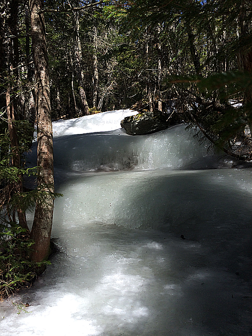
There is running trickling water on parts of the slide.  This should not be stepped on as there is a slimy algae substance that is super slick!
  
 The slide heads back into the woods for a few hundred feet where it reaches a gem pool below another layer of shelf to get up.  This one was too wet to climb so I went up a herd path off to the left.

 Downes Brook Slide gem pool

 Breaking out into the open where there is an obstructed view up to Mount Passaconway.  There is also a ring bolted into the slide.  I wonder what it was used for back in the early to mid twentieth century??!!

 Along the slab there are faded blazes from when the trail was illegally blazed.

 One last canopy section of layered shelf to climb up.  I stayed to the right and found dry slab to navigate up and over it.  There is a herd path to the left that bypasses the slab here.

 Back out into the open.  I hike up until I reach this slick shelf that runs into a pool.  At this spot I head into the woods on the right.

 The trees have 'acid' bubble blazes on them from the tree trying to heal itself or from the forest service attempting to remove the white blazes on the trees.  Not quite sure which one it is

 The slide is overgrown and steep.  It eventually ends at the Walden Trail downlook a few tenths of a mile below the summit

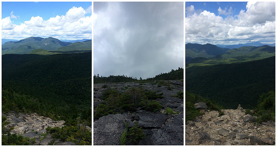
 Great view from the downlook!

 Mount Passaconaway summit and the outlook just below the summit

 Heading along the Dicey's Mill and Rollins Trail towards Mount Whiteface

 Mount Whitface's summit is just a cairn on the side of the trail with a marker nailed to a tree.  Not too exciting.

 The Kate Sleeper / Downes Brook Trail junction

 Heading into the blowdown corridor on the Kate Sleeper Trail.

 Impressive blowdown patch!

 The Kate Sleeper trail has great footing and easy grades as it makes it's way along the ridge past East and West Sleeper.

 The Sleeper Slide.

 Looking down the South Tripyramid Slide.

 Looking down and up the South Tri Slide.

 Below the slide the Mount Tripyramid Trail levels out and the footing becomes much easier.

 Hiking along the Livermore Trail past an old logging camp.

 The foot of the North Tripyramid Slide.

 The slide is very steep and starts of narrow.

 Towards the middle of the slide the views start to open up.

 Mount Tecumseh and the Osceola's.

 The upper part of the slide is wide open and fun!

 The big cairn at the top of the slide, it looks like a rock waterfall that just drops away!

 View from a downlook next to the summit of Mount Tripyramid

 Hiking down the Sabbaday Brook Trail.  It''s steep and rough for the first 0.75 miles then the grades ease up and the footing improves dramatically.

Sabbaday Falls.

Hiking the Kanc back to the Downes Brook trailhead.

Signs spotted along the way.

Route for the day.

elevation, time, and mileage data, click here for more details